Bus station nearby Seeduwa Junction Bus Station
Sri Lanka
Bus station nearby Seeduwa Junction Bus Station
Seeduwa Junction Bus Station
Negombo-Colombo Main Road, Seeduwa, Gampaha, LK Sri Lanka
contacts phone
:
+94
Latitude:
7.1322779
, Longitude:
79.8758772
larger map & directions
read more
nearest Bus station
434 m
Seeduwa Bus Station
Negombo-Colombo Main Road, Seeduwa
Bus station
read more
632 m
Seeduwa Brandix Bus Station
Negombo Road, Seeduwa
Bus station
read more
2.551 km
18th Mile Post Bus Stop
Negombo Road, Katunayake
Bus station
read more
2.624 km
Katunayake Bus Station
Homagama
Bus station
read more
2.786 km
Raddolugama Bus Staion
Katunayake
Bus station
read more
2.834 km
Thotupola Bus Stop
Negombo Road, Dehiyagatha
Bus station
read more
2.875 km
IET Bus Stop
Katunayake
Bus station
read more
3.891 km
Bus Station
Averiyawatte,, කටුනායක
Bus station
read more
4.033 km
Katunayaka Bus Stop
Negombo-Colombo Main Road, Negombo
Bus station
read more
4.08 km
Millenium City Bus Stop
Nivasie Pura Road
Bus station
read more
4.346 km
Lion Junction Bus Stop
B111
Bus station
read more
4.352 km
Air Force Camp Bus Stop
Isuru Uyana
Bus station
read more
4.468 km
Volanka Bus Stop
B111
Bus station
read more
4.938 km
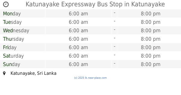
Katunayake Expressway Bus Stop
Katunayake
Bus station
read more
5.363 km
CTB Handiya Bus Stop
Ja Ela-Ekala-Gampaha-Yakkala Highway, Ja-Ela
Bus station
read more
5.392 km
CTB Handiya
Ja-Ela
Bus station
read more
6.218 km
Ja-ela Bus Station
Ja-Ela
Bus station
read more
7.551 km
Rukgahamula Bus Stop
Ja-Ela
Bus station
read more
7.607 km
Mabima Bus Stop
Ja Ela-Ekala-Gampaha-Yakkala Highway
Bus station
read more
8.976 km
Negombo Bus Terminal
Archbishop Nicholas Marcus Fernando Mawatha, Negombo
Bus station
read more
9.016 km
Boragodawatte
Minuwangoda Roundabout, Yatiyana
Bus station
read more
11.888 km
Eksath Mawatha Bus Stop
B288, Udugampola
Bus station
read more
14.017 km
Ragama Factory Delpe Junction Bus Stop
B13, Ragama
Bus station
read more
14.207 km
Mola Handiya Bus Stop
Udugampola - Divulapitiya Road, Korase
Bus station
read more
16.734 km
Kadawata Bus Station
Kandy Road, Kadawatha
Bus station
read more
📑
all categories
Accounting
Administrative area level 1
Administrative area level 2
Airport
Amusement park
Aquarium
Art gallery
Atm
Bakery
Bank
Bar
Beauty salon
Bicycle store
Book store
Bowling alley
Bus station
Cafe
Campground
Car dealer
Car rental
Car repair
Car wash
Casino
Cemetery
Church
City hall
Clothing store
Colloquial area
Convenience store
Country
Courthouse
Dentist
Department store
Doctor
Electrician
Electronics store
Embassy
Finance
Fire station
Florist
Food
Funeral home
Furniture store
Gas station
General contractor
Grocery or supermarket
Gym
Hair care
Hardware store
Health
Hindu Temple
Home goods store
Hospital
Insurance agency
Intersection
Jewelry store
Laundry
Lawyer
Library
Light rail station
Liquor store
Local government office
Locality
Locksmith
Lodging
Meal delivery
Meal takeaway
Mosque
Movie rental
Movie theater
Moving company
Museum
Natural feature
Neighborhood
Night club
Painter
Park
Parking
Pet store
Pharmacy
Physiotherapist
Place of worship
Plumber
Point of interest
Police
Political
Post office
Premise
Real estate agency
Restaurant
Roofing contractor
Route
Rv park, camping
School
Shoe store
Shopping mall
Spa
Stadium
Storage
Store
Subpremise
Supermarket
Synagogue
Taxi stand
Train station
Transit station
Travel agency
University
Veterinary care
Zoo
administrative area level 3
sublocality level 1
sublocality level 2
↑