Cafe nearby Don's Deli
Sri Lanka
Cafe nearby Don's Deli
Don's Deli
53, Haig Road, Colombo, Colombo, LK Sri Lanka
contacts phone
:
+94 112 055 606
website:
www.dstanleys.com
Latitude:
6.8909715
, Longitude:
79.8540113
larger map & directions
read more
nearest Cafe
275 m
Mythi Cafe
Milagiriya, Colombo
Cafe
read more
301 m
Barista
7/2 Station Road, Colombo
Cafe
read more
331 m
The Fab
Colombo
Cafe
read more
374 m
Island Coffee
Shrubbery Garden Road, Colombo
Cafe
read more
387 m
Caffe Vita
Colombo
Cafe
read more
489 m
Raj Bojun
Milagiriya, Colombo
Cafe
read more
589 m
Ankara Turkish Restaurant
25 Milagiriya Avenue, Colombo
Cafe
read more
595 m
Kopikade Botel
40 Edward Lane, Colombo
Cafe
read more
596 m
BOO Cafe
Marine Drive, Colombo
Cafe
read more
603 m
SugarCube
No.15 R.A., 05 R. A. De Mel Mawatha, Colombo
Cafe
read more
727 m
Bakes by Bella
8, Alfred House Avenue, Colombo
Cafe
read more
740 m
Brewbar
Milagiriya, Colombo
Cafe
read more
786 m
Cafe Sociale
252A, Galle Road, Colombo - 04, Colombo
Cafe
read more
792 m
Cafè Socialè
Milagiriya, Colombo
Cafe
read more
798 m
Monique's Cakes and Desserts
Milagiriya, Colombo
Cafe
read more
854 m
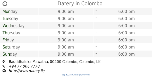
Datery
203C, Bauddhaloka Mawatha, Colombo
Cafe
read more
876 m
Highland Milk Bar
Galle Road, Colombo
Cafe
read more
883 m
Bubblelement Colombo
33 Queen's Road, Colombo
Cafe
read more
904 m
E-Cafe
120/A, Sri Sambuddhathva Jayanthi Mawatha, Colombo
Cafe
read more
911 m
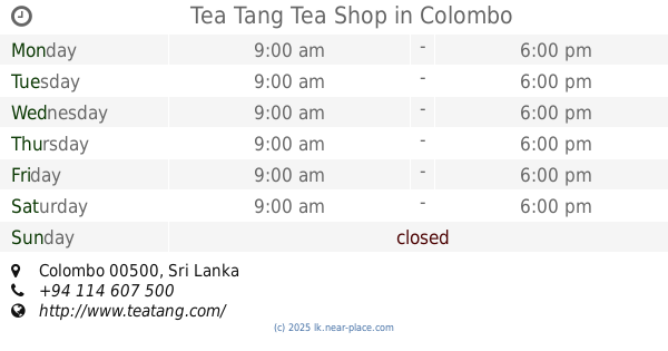
Tea Tang Tea Shop
Colombo
Cafe
read more
956 m
Shakthi Food
333 Galle Road, Colombo
Cafe
read more
981 m
Klassy Pastry Shop
2C De Fonseka Road, Colombo
Cafe
read more
1.082 km
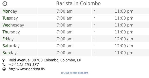
Barista
No. 7, Reid Avenue, Colombo
Cafe
read more
1.126 km
Java Lounge - Bambalapitiya
302 Galle Road, Colombo
Cafe
read more
1.171 km
Burger Hut
R. A. De Mel Mawatha, Colombo
Cafe
read more
📑
all categories
Accounting
Administrative area level 1
Administrative area level 2
Airport
Amusement park
Aquarium
Art gallery
Atm
Bakery
Bank
Bar
Beauty salon
Bicycle store
Book store
Bowling alley
Bus station
Cafe
Campground
Car dealer
Car rental
Car repair
Car wash
Casino
Cemetery
Church
City hall
Clothing store
Colloquial area
Convenience store
Country
Courthouse
Dentist
Department store
Doctor
Electrician
Electronics store
Embassy
Finance
Fire station
Florist
Food
Funeral home
Furniture store
Gas station
General contractor
Grocery or supermarket
Gym
Hair care
Hardware store
Health
Hindu Temple
Home goods store
Hospital
Insurance agency
Intersection
Jewelry store
Laundry
Lawyer
Library
Light rail station
Liquor store
Local government office
Locality
Locksmith
Lodging
Meal delivery
Meal takeaway
Mosque
Movie rental
Movie theater
Moving company
Museum
Natural feature
Neighborhood
Night club
Painter
Park
Parking
Pet store
Pharmacy
Physiotherapist
Place of worship
Plumber
Point of interest
Police
Political
Post office
Premise
Real estate agency
Restaurant
Roofing contractor
Route
Rv park, camping
School
Shoe store
Shopping mall
Spa
Stadium
Storage
Store
Subpremise
Supermarket
Synagogue
Taxi stand
Train station
Transit station
Travel agency
University
Veterinary care
Zoo
administrative area level 3
sublocality level 1
sublocality level 2
↑