Cafe nearby Nimals Snack Bar
Sri Lanka
Cafe nearby Nimals Snack Bar
Nimals Snack Bar
Sir Cyryl de Zoysa Mawatha, Kalutara Sri Lanka
contacts phone
:
+94
Latitude:
6.5803576
, Longitude:
79.9636726
read more
nearest Cafe
238 m
Soy Foods
Kalutara
Cafe
read more
2.571 km
Bread Box
Kalutara
Cafe
read more
3.359 km
Ranil Studio
Katukurunda
Cafe
read more
3.742 km
Binodya Food Centet
Kaluthara-Horana Road, Wadduwa
Cafe
read more
4.459 km
New Disna Hotel & Cool Spot
Colombo - Galle - Hambantota - Wellawaya Highway, Katukurunda
Cafe
read more
4.531 km
Sweet Cake Corner
Nagoda - Kalawellawa - Bellapitiya Road, Katukurunda
Cafe
read more
4.62 km
Weniwelketiya
Dodangoda, Katukurunda
Cafe
read more
4.721 km
S&D Foods
Bombuwala
Cafe
read more
5.515 km
Pups n Sips
427 Samanthara Road, Wadduwa
Cafe
read more
5.713 km
Chinese Little Hut
Nagoda - Kalawellawa - Bellapitiya Road, Gan-Ima
Cafe
read more
6.619 km
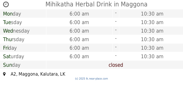
Mihikatha Herbal Drink
A2, Maggona
Cafe
read more
8.467 km
Vision Com
Wadduwa
Cafe
read more
8.881 km
Anagi Stores
Maharekma, Wadduwa
Cafe
read more
8.922 km
Sk Studio
80, No 3
Cafe
read more
9.741 km
Snow Suger
Wadduwa East, Wadduwa
Cafe
read more
11.822 km
H.S Hotel
Beruwala
Cafe
read more
12.935 km
Fz Creators
43 Bakir Makar Avenue, Beruwala
Cafe
read more
13.238 km
Java Cafe
elagahawatta,yatadola,mathugama, 23 Kalutara-Matugama Road, Matugama
Cafe
read more
14.232 km
Danasiri Cafe
Horana - Anguruwatota - Mathugama - Aluthgama Road
Cafe
read more
14.778 km
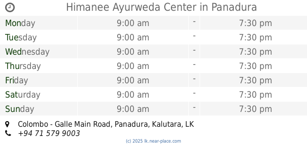
Himanee Ayurweda Center
Colombo - Galle Main Road, Panadura
Cafe
read more
15.144 km
Bread Line
Panadura
Cafe
read more
16.058 km
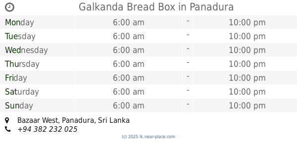
Galkanda Bread Box
Bazaar West, Panadura
Cafe
read more
17.813 km
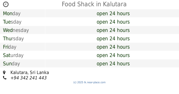
Food Shack
Kalutara
Cafe
read more
18.189 km
Milk Bar
Horana
Cafe
read more
18.286 km
Main Canteen
Horana - Anguruwatota - Mathugama - Aluthgama Road, Horana
Cafe
read more
📑
all categories
Accounting
Administrative area level 1
Administrative area level 2
Airport
Amusement park
Aquarium
Art gallery
Atm
Bakery
Bank
Bar
Beauty salon
Bicycle store
Book store
Bowling alley
Bus station
Cafe
Campground
Car dealer
Car rental
Car repair
Car wash
Casino
Cemetery
Church
City hall
Clothing store
Colloquial area
Convenience store
Country
Courthouse
Dentist
Department store
Doctor
Electrician
Electronics store
Embassy
Finance
Fire station
Florist
Food
Funeral home
Furniture store
Gas station
General contractor
Grocery or supermarket
Gym
Hair care
Hardware store
Health
Hindu Temple
Home goods store
Hospital
Insurance agency
Intersection
Jewelry store
Laundry
Lawyer
Library
Light rail station
Liquor store
Local government office
Locality
Locksmith
Lodging
Meal delivery
Meal takeaway
Mosque
Movie rental
Movie theater
Moving company
Museum
Natural feature
Neighborhood
Night club
Painter
Park
Parking
Pet store
Pharmacy
Physiotherapist
Place of worship
Plumber
Point of interest
Police
Political
Post office
Premise
Real estate agency
Restaurant
Roofing contractor
Route
Rv park, camping
School
Shoe store
Shopping mall
Spa
Stadium
Storage
Store
Subpremise
Supermarket
Synagogue
Taxi stand
Train station
Transit station
Travel agency
University
Veterinary care
Zoo
administrative area level 3
sublocality level 1
sublocality level 2
↑