Cafe nearby Rajah Ice Cream
Sri Lanka
Cafe nearby Rajah Ice Cream
Rajah Ice Cream
Jaffna, Sri Lanka
contacts phone
:
+94
Latitude:
9.686973
, Longitude:
80.0153322
larger map & directions
read more
nearest Cafe
644 m
SDC Canteen
Kokuvil East
Cafe
read more
648 m
New Kuhananthabavan
AB16, Jaffna
Cafe
read more
796 m
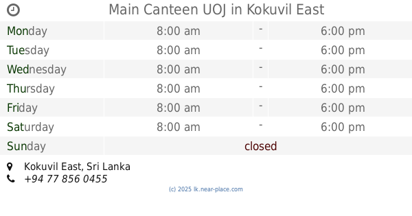
Main Canteen UOJ
Kokuvil East
Cafe
read more
812 m
Main Canteen 1 UOJ
Kokuvil East
Cafe
read more
914 m
CafeEV Cabs
126, Arasady Road, Kantharmadam, Jaffna
Cafe
read more
947 m
Yummy Cafe
Jaffna
Cafe
read more
1.036 km
Arul Bakery Café
Jaffna
Cafe
read more
1.094 km
Maarutham
Neeraviyadi, College Lane, Jaffna
Cafe
read more
1.268 km
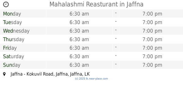
Mahalashmi Reasturant
Jaffna - Kokuvil Road, Jaffna
Cafe
read more
1.311 km
ABY Bake & Cream House
Jaffna
Cafe
read more
1.397 km
HamsuBakes
251 Arasadi Road, Jaffna
Cafe
read more
1.404 km
Shalini Foods
Jaffna
Cafe
read more
1.409 km
Hit City Hotel
Jaffna
Cafe
read more
1.512 km
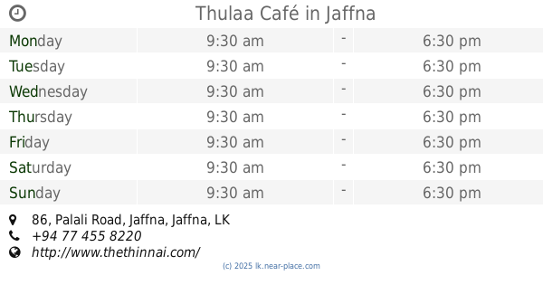
Thulaa Café
86 Palali Road, Jaffna
Cafe
read more
1.519 km
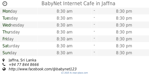
BabyNet Internet Cafe
Jaffna
Cafe
read more
1.529 km
sam cafe
Kannathiddy, Jaffna
Cafe
read more
1.718 km
Royal Bombay Sweets and Snacks
No.212, Kasthuriyar Road,, Jaffna
Cafe
read more
1.792 km
New Thurkka Bakery
Kokuvil East
Cafe
read more
1.915 km
Albha Mixtures
Kannathiddy, Jaffna
Cafe
read more
1.934 km
praba store
Jaffna
Cafe
read more
1.934 km
Lucky Cafe
Jaffna
Cafe
read more
1.962 km
Thambi Tea Room
No.18, Stanly Road, Jaffna, Jaffna
Cafe
read more
2.114 km
TKS Transport
Navalar Road, Jaffna
Cafe
read more
2.205 km
Star Ice Cream
Manipay Road, Jaffna
Cafe
read more
2.214 km
SIvanthantha Food store
Jaffna
Cafe
read more
📑
all categories
Accounting
Administrative area level 1
Administrative area level 2
Airport
Amusement park
Aquarium
Art gallery
Atm
Bakery
Bank
Bar
Beauty salon
Bicycle store
Book store
Bowling alley
Bus station
Cafe
Campground
Car dealer
Car rental
Car repair
Car wash
Casino
Cemetery
Church
City hall
Clothing store
Colloquial area
Convenience store
Country
Courthouse
Dentist
Department store
Doctor
Electrician
Electronics store
Embassy
Finance
Fire station
Florist
Food
Funeral home
Furniture store
Gas station
General contractor
Grocery or supermarket
Gym
Hair care
Hardware store
Health
Hindu Temple
Home goods store
Hospital
Insurance agency
Intersection
Jewelry store
Laundry
Lawyer
Library
Light rail station
Liquor store
Local government office
Locality
Locksmith
Lodging
Meal delivery
Meal takeaway
Mosque
Movie rental
Movie theater
Moving company
Museum
Natural feature
Neighborhood
Night club
Painter
Park
Parking
Pet store
Pharmacy
Physiotherapist
Place of worship
Plumber
Point of interest
Police
Political
Post office
Premise
Real estate agency
Restaurant
Roofing contractor
Route
Rv park, camping
School
Shoe store
Shopping mall
Spa
Stadium
Storage
Store
Subpremise
Supermarket
Synagogue
Taxi stand
Train station
Transit station
Travel agency
University
Veterinary care
Zoo
administrative area level 3
sublocality level 1
sublocality level 2
↑