Cafe nearby Starbeans Cafe
Sri Lanka
Cafe nearby Starbeans Cafe
Starbeans Cafe
Asian Highway 43, Weligama, Matara, LK Sri Lanka
contacts phone
:
+94 412 254 464
Latitude:
5.9478165
, Longitude:
80.457271
larger map & directions
read more
nearest Cafe
50 m
Wood Space
Mirissa
Cafe
read more
72 m
Barista
Galle Road, Mirissa
Cafe
read more
107 m
Shady Lane Mirissa
Diyagalana Road Yatipila Mirissa, Mirissa
Cafe
read more
107 m
Shady Lane Mirissa
Mirissa
Cafe
read more
189 m
Jagros Mirissa
Mirissa
Cafe
read more
319 m
Aloha coffee gallery
Sunanda Road, Mirissa
Cafe
read more
359 m
Thinuli Tea Center
No. 02 Udupila Rd, Mirissa
Cafe
read more
365 m
Cafe Relish
A2, Mirissa
Cafe
read more
374 m
Amarasinghe Residences and Restaurant, Udupila, Mirissa
Mirissa
Cafe
read more
390 m
Pachamama Caffe
Udupila Road, Mirissa
Cafe
read more
413 m
Cafe Olga
Kusum, Udupila, Mirissa,
Cafe
read more
671 m
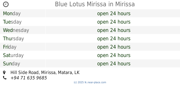
Blue Lotus Mirissa
Hill Side , Mirissa, Hill Side Road, Mirissa
Cafe
read more
865 m
Dewmi rotti shop
Mirissa
Cafe
read more
1.429 km
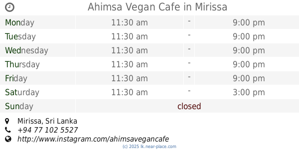
Ahimsa Vegan Cafe
Mirissa
Cafe
read more
2.549 km
Sunimala Restaurant
Sunimala, Thalaramba , Mirissa, Matara Road
Cafe
read more
2.58 km
Ranga Cafe
Matara Road
Cafe
read more
3.408 km
MBC (Mirissa Baking Company)
Marriott Weligama Bay Resort & Spa, Matara Road, Weligama
Cafe
read more
3.425 km
MBC (Mirissa Baking Company)
700, Matara Road, Pelana, Weligama
Cafe
read more
3.639 km
Cosey Mud House
Matara
Cafe
read more
3.645 km
Palms Cafe & Friendly House
642 A2, Weligama
Cafe
read more
3.736 km
Hangtime Hostel
5.972958, 80.434851, Weligama By Pass Road
Cafe
read more
3.786 km
Cafe Weligama
Weligama
Cafe
read more
3.928 km
Sathira Cafe
Weligama
Cafe
read more
4.001 km
Kaori Cafe and Villa
Weligama By Pass Road, Weligama
Cafe
read more
4.071 km
Game Station Gaming Cafe Weligama
39/1 samaraweera pedesa, Weligama
Cafe
read more
📑
all categories
Accounting
Administrative area level 1
Administrative area level 2
Airport
Amusement park
Aquarium
Art gallery
Atm
Bakery
Bank
Bar
Beauty salon
Bicycle store
Book store
Bowling alley
Bus station
Cafe
Campground
Car dealer
Car rental
Car repair
Car wash
Casino
Cemetery
Church
City hall
Clothing store
Colloquial area
Convenience store
Country
Courthouse
Dentist
Department store
Doctor
Electrician
Electronics store
Embassy
Finance
Fire station
Florist
Food
Funeral home
Furniture store
Gas station
General contractor
Grocery or supermarket
Gym
Hair care
Hardware store
Health
Hindu Temple
Home goods store
Hospital
Insurance agency
Intersection
Jewelry store
Laundry
Lawyer
Library
Light rail station
Liquor store
Local government office
Locality
Locksmith
Lodging
Meal delivery
Meal takeaway
Mosque
Movie rental
Movie theater
Moving company
Museum
Natural feature
Neighborhood
Night club
Painter
Park
Parking
Pet store
Pharmacy
Physiotherapist
Place of worship
Plumber
Point of interest
Police
Political
Post office
Premise
Real estate agency
Restaurant
Roofing contractor
Route
Rv park, camping
School
Shoe store
Shopping mall
Spa
Stadium
Storage
Store
Subpremise
Supermarket
Synagogue
Taxi stand
Train station
Transit station
Travel agency
University
Veterinary care
Zoo
administrative area level 3
sublocality level 1
sublocality level 2
↑