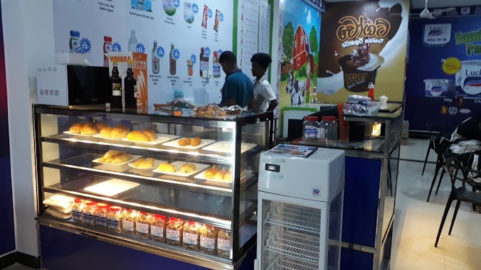
Cafe nearby Tasty Food Cabins
Sri Lanka
Cafe nearby Tasty Food Cabins
Tasty Food Cabins
Puwakwatha Road Sri Lanka
contacts phone
:
+94
Latitude:
6.8369472
, Longitude:
80.0365239
read more
nearest Cafe
1.144 km
DHM Bakery & Cafe
Kurunduwatta, Colombo
Cafe
read more
1.68 km
W W Motors
Gehenuwala
Cafe
read more
1.684 km
Sandeepa Hotel
Godagama South, Godagama
Cafe
read more
2.275 km
On Flavour - Ice cream rolls
Godagama
Cafe
read more
2.409 km
Silver Buglers
Homagama
Cafe
read more
2.581 km
Cafe 10th Head Office
Keremulla Road, Homagama
Cafe
read more
2.915 km
R P Hotel & Bakers
Avissawella Road
Cafe
read more
3.65 km
Super PC Gaming Zone
Colombo - Batticaloa Highway, Homagama
Cafe
read more
3.757 km
NLDB Milk Shop
Station Road, Homagama
Cafe
read more
4.063 km
Dragon Heart Foods
Habarakada
Cafe
read more
5.005 km
Asiri Hotel
No. 603, Galawila Road, Homagama
Cafe
read more
6.104 km
Reliance
Padukka
Cafe
read more
6.415 km
eKOM LANKA
32/1E Kaduwela - Athurugiriya Road, Godagama
Cafe
read more
6.641 km
Tea Villa
A4 Colombo - Batticaloa Highway, Padukka
Cafe
read more
7.004 km
Hot Hot Hotel
Thaldiyawala
Cafe
read more
11.596 km
Rapid Fresh Cafe
Thalawathugoda, East
Cafe
read more
12.052 km
Janatha Bake House
110 High Level Road, Maharagama
Cafe
read more
12.415 km
Sweet Surrender
Pelawatte, Kumarage watta
Cafe
read more
12.877 km
Public Canteen
NEW OPD Building, 3rd Floor, Room 335 New OPD Building To Linac Building Path, Maharagama
Cafe
read more
13.311 km
Lucky Kiri Katha - Bokundara
Bokundara, Piliyandala
Cafe
read more
13.615 km
Abeyrathna Groceries
Moratuwa
Cafe
read more
15.233 km
The Fab
Kotte - Bope Road, Battaramulla
Cafe
read more
15.632 km
Milk Bar කිරිහල
Moratuwa
Cafe
read more
19.969 km
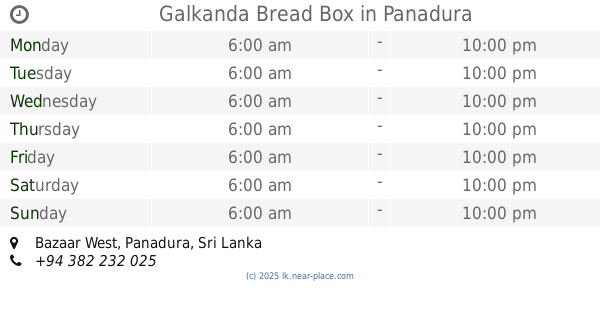
Galkanda Bread Box
Bazaar West, Panadura
Cafe
read more
20.412 km
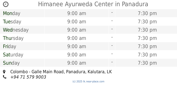
Himanee Ayurweda Center
Colombo - Galle Main Road, Panadura
Cafe
read more
📑
all categories
Accounting
Administrative area level 1
Administrative area level 2
Airport
Amusement park
Aquarium
Art gallery
Atm
Bakery
Bank
Bar
Beauty salon
Bicycle store
Book store
Bowling alley
Bus station
Cafe
Campground
Car dealer
Car rental
Car repair
Car wash
Casino
Cemetery
Church
City hall
Clothing store
Colloquial area
Convenience store
Country
Courthouse
Dentist
Department store
Doctor
Electrician
Electronics store
Embassy
Finance
Fire station
Florist
Food
Funeral home
Furniture store
Gas station
General contractor
Grocery or supermarket
Gym
Hair care
Hardware store
Health
Hindu Temple
Home goods store
Hospital
Insurance agency
Intersection
Jewelry store
Laundry
Lawyer
Library
Light rail station
Liquor store
Local government office
Locality
Locksmith
Lodging
Meal delivery
Meal takeaway
Mosque
Movie rental
Movie theater
Moving company
Museum
Natural feature
Neighborhood
Night club
Painter
Park
Parking
Pet store
Pharmacy
Physiotherapist
Place of worship
Plumber
Point of interest
Police
Political
Post office
Premise
Real estate agency
Restaurant
Roofing contractor
Route
Rv park, camping
School
Shoe store
Shopping mall
Spa
Stadium
Storage
Store
Subpremise
Supermarket
Synagogue
Taxi stand
Train station
Transit station
Travel agency
University
Veterinary care
Zoo
administrative area level 3
sublocality level 1
sublocality level 2
↑