Cafe nearby The Gourmet Station
Sri Lanka
Cafe nearby The Gourmet Station
The Gourmet Station
441, A2, Colombo, Colombo, LK Sri Lanka
contacts phone
:
+94 76 971 8239
Latitude:
6.900806
, Longitude:
79.8532921
larger map & directions
read more
nearest Cafe
302 m
Raxawa Tea Lounge
532/3J Marine Drive, Colombo
Cafe
read more
347 m
Bubblelement Colombo
33 Queen's Road, Colombo
Cafe
read more
425 m
Bakes by Bella
8, Alfred House Avenue, Colombo
Cafe
read more
452 m
Sun Rise Cafe
Colombo
Cafe
read more
485 m
Mitsis
Bagatalle Road, Colombo
Cafe
read more
564 m
Kopikade Botel
40 Edward Lane, Colombo
Cafe
read more
633 m
Coffee & Company
37/3, පෙඩ්රිස් පාර, කොළඹ
Cafe
read more
674 m
Cafe Cabin
Deal Place, Colombo
Cafe
read more
740 m
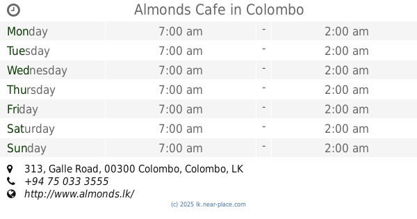
Almonds Cafe
313 Galle Road, Colombo
Cafe
read more
750 m
Brewbar
Milagiriya, Colombo
Cafe
read more
751 m
Caffe Vita
Colombo
Cafe
read more
764 m
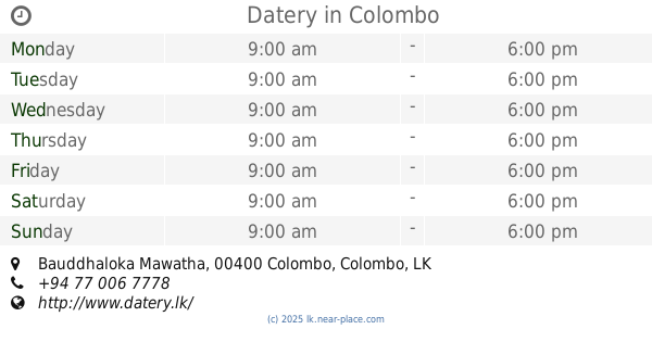
Datery
203C, Bauddhaloka Mawatha, Colombo
Cafe
read more
783 m
The Fab
Colombo
Cafe
read more
803 m
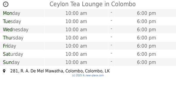
Ceylon Tea Lounge
281 R. A. De Mel Mawatha, Colombo
Cafe
read more
827 m
Mythi Cafe
Milagiriya, Colombo
Cafe
read more
828 m
Royal College Milk Bar
Colombo
Cafe
read more
848 m
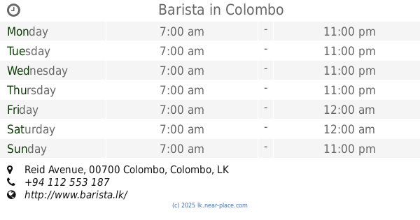
Barista
No. 7, Reid Avenue, Colombo
Cafe
read more
936 m
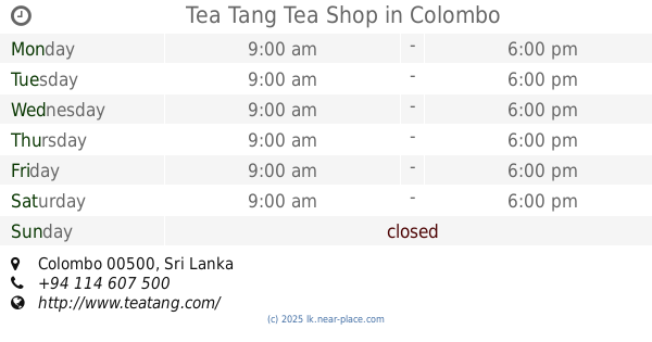
Tea Tang Tea Shop
Colombo
Cafe
read more
951 m
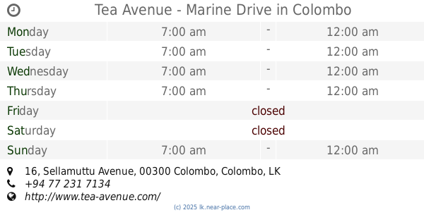
Tea Avenue - Marine Drive
16 Sellamuttu Avenue, Colombo
Cafe
read more
968 m
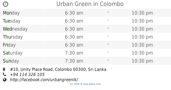
Urban Green
#10, Unity Place Road, Colombo
Cafe
read more
982 m
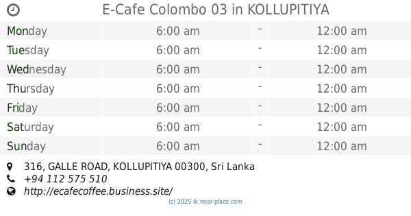
E-Cafe Colombo 03
316, GALLE ROAD, KOLLUPITIYA
Cafe
read more
993 m
The Commons Coffee House
39 A, Flower Road, Colombo
Cafe
read more
1.036 km
Raj Bojun
Milagiriya, Colombo
Cafe
read more
1.064 km
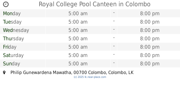
Royal College Pool Canteen
Philip Gunewardena Mawatha, Colombo
Cafe
read more
1.068 km
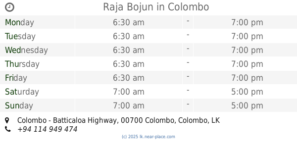
Raja Bojun
Colombo - Batticaloa Highway, Colombo
Cafe
read more
📑
all categories
Accounting
Administrative area level 1
Administrative area level 2
Airport
Amusement park
Aquarium
Art gallery
Atm
Bakery
Bank
Bar
Beauty salon
Bicycle store
Book store
Bowling alley
Bus station
Cafe
Campground
Car dealer
Car rental
Car repair
Car wash
Casino
Cemetery
Church
City hall
Clothing store
Colloquial area
Convenience store
Country
Courthouse
Dentist
Department store
Doctor
Electrician
Electronics store
Embassy
Finance
Fire station
Florist
Food
Funeral home
Furniture store
Gas station
General contractor
Grocery or supermarket
Gym
Hair care
Hardware store
Health
Hindu Temple
Home goods store
Hospital
Insurance agency
Intersection
Jewelry store
Laundry
Lawyer
Library
Light rail station
Liquor store
Local government office
Locality
Locksmith
Lodging
Meal delivery
Meal takeaway
Mosque
Movie rental
Movie theater
Moving company
Museum
Natural feature
Neighborhood
Night club
Painter
Park
Parking
Pet store
Pharmacy
Physiotherapist
Place of worship
Plumber
Point of interest
Police
Political
Post office
Premise
Real estate agency
Restaurant
Roofing contractor
Route
Rv park, camping
School
Shoe store
Shopping mall
Spa
Stadium
Storage
Store
Subpremise
Supermarket
Synagogue
Taxi stand
Train station
Transit station
Travel agency
University
Veterinary care
Zoo
administrative area level 3
sublocality level 1
sublocality level 2
↑