Church nearby Mary Matha Church
Sri Lanka
Church nearby Mary Matha Church
Mary Matha Church
Adampan Sri Lanka
contacts phone
:
+94
Latitude:
8.9570031
, Longitude:
79.993161
read more
nearest Church
2.069 km
Our Lady of Sorrow Church
Adampan
Church
read more
2.956 km
Our Lady of Lourdes Church - Manthai, Mannar
Navathkuli - Karativu - Mannar Hwy
Church
read more
3.033 km
Our Lady of Lourdes Statue
Sri Lanka
Church
read more
3.235 km
Church of St.Philip Neris
Adampan
Church
read more
3.371 km
secret heart Jesus christ Ielanthaiwan
Uyilankulam Adampan Road, Ielanthaiwan
Church
read more
4.274 km
Our Lady of Refuge Church
Adampan
Church
read more
5.402 km
Church of St.Francis Xavier
Sri Lanka
Church
read more
7.019 km
Infant Jesus Church Alankulam
Church
read more
8.443 km
Annai Velankanni Church
Mannar
Church
read more
8.537 km
Zion Gospel Church
Unnamed Road, Mannar
Church
read more
9.177 km
Annai Velankanni Church, myth.
Church
read more
9.712 km
Our Lady of Presentation Church
Sri Lanka
Church
read more
9.728 km
St Mary's Church
A14, Mannar
Church
read more
9.771 km
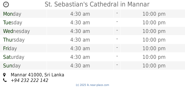
St. Sebastian's Cathedral
Mannar
Church
read more
9.792 km
St.Joseph church
Sri Lanka
Church
read more
9.819 km
Joseph Catechetical Centre
Saint Sebastian's Street, Mannar
Church
read more
10.169 km
St. Anthony's Church
Mannar
Church
read more
10.278 km
புனித வேளாங்கண்ணி மாதா சிற்றாலயம்
Vankalai
Church
read more
10.458 km
Ceylon Penthacostal Misson
Medawachchiya-Talaimannar Highway, Mannar
Church
read more
10.613 km
Infant Jesus Church
Mannar
Church
read more
12.766 km
Church of St Philip Neris Athikuly
Mannar
Church
read more
13.688 km
Wellness Holy Mother Church Nanattan
Murunkan - Nanattan Road
Church
read more
13.924 km
Pidarikulam St.Antonys church
Mannar
Church
read more
14.382 km
St.Antony's church
Pallankoddai
Church
read more
17.208 km
Natkarunai Nathar Aalayam Joshepvaz Nagar
Puthukkudiyiruppu - Karisal Rd, Mathottam
Church
read more
📑
all categories
Accounting
Administrative area level 1
Administrative area level 2
Airport
Amusement park
Aquarium
Art gallery
Atm
Bakery
Bank
Bar
Beauty salon
Bicycle store
Book store
Bowling alley
Bus station
Cafe
Campground
Car dealer
Car rental
Car repair
Car wash
Casino
Cemetery
Church
City hall
Clothing store
Colloquial area
Convenience store
Country
Courthouse
Dentist
Department store
Doctor
Electrician
Electronics store
Embassy
Finance
Fire station
Florist
Food
Funeral home
Furniture store
Gas station
General contractor
Grocery or supermarket
Gym
Hair care
Hardware store
Health
Hindu Temple
Home goods store
Hospital
Insurance agency
Intersection
Jewelry store
Laundry
Lawyer
Library
Light rail station
Liquor store
Local government office
Locality
Locksmith
Lodging
Meal delivery
Meal takeaway
Mosque
Movie rental
Movie theater
Moving company
Museum
Natural feature
Neighborhood
Night club
Painter
Park
Parking
Pet store
Pharmacy
Physiotherapist
Place of worship
Plumber
Point of interest
Police
Political
Post office
Premise
Real estate agency
Restaurant
Roofing contractor
Route
Rv park, camping
School
Shoe store
Shopping mall
Spa
Stadium
Storage
Store
Subpremise
Supermarket
Synagogue
Taxi stand
Train station
Transit station
Travel agency
University
Veterinary care
Zoo
administrative area level 3
sublocality level 1
sublocality level 2
↑