Church nearby St. Joseph Church
Sri Lanka
Church nearby St. Joseph Church
St. Joseph Church
Batticaloa, Sri Lanka
contacts phone
:
+94
Latitude:
7.7261677
, Longitude:
81.704899
larger map & directions
read more
nearest Church
557 m
St. Ignatius' Church
Kallady Mugathuvaram
Church
read more
652 m
Mayer Hall
St Sebastian Church, B542, Batticaloa
Church
read more
652 m
Mayer Hall
St Sebastian Church, Lady Manning Drive, Batticaloa
Church
read more
652 m
St Sebastian Church
Koddimunai
Church
read more
701 m
Grace Redemption Fellowship
Batticaloa
Church
read more
802 m
Word of Power Ministries
118, Bar Road, Batticaloa., Srilanka, Batticaloa
Church
read more
821 m
Our Lady Of Lourdes Church
B46, Batticaloa
Church
read more
855 m
Assembly of God Church Batticaloa
22a, B27, Batticaloa
Church
read more
913 m
St. Antony's Church
Navalady Road, Dutch Bar
Church
read more
931 m
Prayer House of Infant Jesus
Boundary Road, Batticaloa
Church
read more
967 m
Our Lady Of Lourdes Church
Batticaloa
Church
read more
1.023 km
Jesus Christ Is Lord
Tisseverasingam Square 1st Cross Street, Batticaloa
Church
read more
1.079 km
Methodist Church
Trinco Road, Batticaloa
Church
read more
1.158 km
Salvation Army
Trincomalee Highway, Batticaloa
Church
read more
1.163 km
chirstion chirch
Batticaloa
Church
read more
1.211 km
Ceylon Pentacostal Mission
Batticaloa
Church
read more
1.249 km
East Lanka Evangelical Mission
258/2 Ciril Land, Batticaloa
Church
read more
1.631 km
St. Andrew's Church
Batticaloa
Church
read more
1.72 km
Our Lady of Perpetual Help Church
Unnamed Rd, Batticaloa, Sri Lanka
Church
read more
1.862 km
Wesleyan Church Methodist Church Puliyantheevu, Batticaloa
Chapel Street, Batticaloa
Church
read more
1.886 km
St Joseph's Convent
Puliyanthivu
Church
read more
2.001 km
Elroy Worship Mission
Kallady
Church
read more
2.081 km
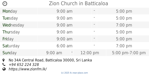
Zion Church Batticaloa Sri Lanka
No 34A Central Road, Batticaloa
Church
read more
2.081 km
Zion Church
No 34A Central Road, Batticaloa
Church
read more
2.103 km
Canaan Fellowship International Church
Covington's Road, Batticaloa
Church
read more
📑
all categories
Accounting
Administrative area level 1
Administrative area level 2
Airport
Amusement park
Aquarium
Art gallery
Atm
Bakery
Bank
Bar
Beauty salon
Bicycle store
Book store
Bowling alley
Bus station
Cafe
Campground
Car dealer
Car rental
Car repair
Car wash
Casino
Cemetery
Church
City hall
Clothing store
Colloquial area
Convenience store
Country
Courthouse
Dentist
Department store
Doctor
Electrician
Electronics store
Embassy
Finance
Fire station
Florist
Food
Funeral home
Furniture store
Gas station
General contractor
Grocery or supermarket
Gym
Hair care
Hardware store
Health
Hindu Temple
Home goods store
Hospital
Insurance agency
Intersection
Jewelry store
Laundry
Lawyer
Library
Light rail station
Liquor store
Local government office
Locality
Locksmith
Lodging
Meal delivery
Meal takeaway
Mosque
Movie rental
Movie theater
Moving company
Museum
Natural feature
Neighborhood
Night club
Painter
Park
Parking
Pet store
Pharmacy
Physiotherapist
Place of worship
Plumber
Point of interest
Police
Political
Post office
Premise
Real estate agency
Restaurant
Roofing contractor
Route
Rv park, camping
School
Shoe store
Shopping mall
Spa
Stadium
Storage
Store
Subpremise
Supermarket
Synagogue
Taxi stand
Train station
Transit station
Travel agency
University
Veterinary care
Zoo
administrative area level 3
sublocality level 1
sublocality level 2
↑