Food nearby Boon Chat Juice Corner
Sri Lanka
Food nearby Boon Chat Juice Corner
Boon Chat Juice Corner
Wattegedara Road, Maharagama, Colombo, LK Sri Lanka
contacts phone
:
+94 77 996 4935
Latitude:
6.8514105
, Longitude:
79.9208962
larger map & directions
read more
nearest Food
253 m
W.K.S. Sons & Enterprises
William Alwis Mawatha, Maharagama
Food
read more
280 m
Anuradha PVT Ltd
157/D, High Level Road, Maharagama
Food
read more
672 m
Thalagala Stores
Maharagama
Food
read more
675 m
Thilaka Jayanthi Cool Spot
Maharagama
Food
read more
709 m
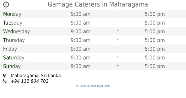
Gamage Caterers
Maharagama
Food
read more
922 m
Vigitha Caterings
Sri Devananda Road, Colombo
Food
read more
947 m
food Outlet
Railway Road, Maharagama
Food
read more
1.114 km
Binupa Juice Bar
Nugagaha Place, Maharagama
Food
read more
1.477 km
Weranjana Food Center
Avissawella Road, Maharagama
Food
read more
1.536 km
Ari Fruit Shop
Wijerama Junction, Nugegoda
Food
read more
1.556 km
Vihari Fresh Juice
Sri Soratha Mawatha, Nugegoda
Food
read more
1.616 km
Cherish Snacks & Beverages
217/a Egodawatta Road, Boralesgamuwa
Food
read more
1.673 km
Saman Catering Service
57/A, B94, Boralesgamuwa
Food
read more
1.763 km
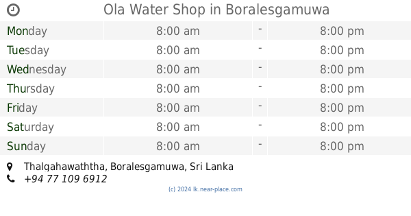
Ola Water Shop
Thalgahawaththa, Boralesgamuwa
Food
read more
1.806 km
Pussella Meat Shop
Piliyandala Road, Maharagama
Food
read more
1.807 km
Abisheka Mandapaya
Avissawella Road, Maharagama
Food
read more
1.807 km
Ruwan Widanage Stores
Avissawella Road, Maharagama
Food
read more
1.963 km
leela stores
117 Polwatta Road, Maharagama
Food
read more
2.018 km
Sisaga Grocery
52 Thalapathpitiya Road, Nugegoda
Food
read more
2.154 km
Asiri Gram Center
Embuldeniya, Nugegoda
Food
read more
2.197 km
Anton Meat Shop
Embuldeniya, Nugegoda
Food
read more
2.332 km
Newsiri Caters
Ruhunupura
Food
read more
2.471 km
Pussella Meat Shop
Old Kottawa Road, Nugegoda
Food
read more
2.472 km
Hot Pack Catering Service
454/3 Temple Road, Sri Jayawardenepura Kotte
Food
read more
2.657 km
Consolidated Business Systems Ltd
Metisuddhagara Road, Boralesgamuwa
Food
read more
📑
all categories
Accounting
Administrative area level 1
Administrative area level 2
Airport
Amusement park
Aquarium
Art gallery
Atm
Bakery
Bank
Bar
Beauty salon
Bicycle store
Book store
Bowling alley
Bus station
Cafe
Campground
Car dealer
Car rental
Car repair
Car wash
Casino
Cemetery
Church
City hall
Clothing store
Colloquial area
Convenience store
Country
Courthouse
Dentist
Department store
Doctor
Electrician
Electronics store
Embassy
Finance
Fire station
Florist
Food
Funeral home
Furniture store
Gas station
General contractor
Grocery or supermarket
Gym
Hair care
Hardware store
Health
Hindu Temple
Home goods store
Hospital
Insurance agency
Intersection
Jewelry store
Laundry
Lawyer
Library
Light rail station
Liquor store
Local government office
Locality
Locksmith
Lodging
Meal delivery
Meal takeaway
Mosque
Movie rental
Movie theater
Moving company
Museum
Natural feature
Neighborhood
Night club
Painter
Park
Parking
Pet store
Pharmacy
Physiotherapist
Place of worship
Plumber
Point of interest
Police
Political
Post office
Premise
Real estate agency
Restaurant
Roofing contractor
Route
Rv park, camping
School
Shoe store
Shopping mall
Spa
Stadium
Storage
Store
Subpremise
Supermarket
Synagogue
Taxi stand
Train station
Transit station
Travel agency
University
Veterinary care
Zoo
administrative area level 3
sublocality level 1
sublocality level 2
↑