Food nearby Cresent
Sri Lanka
Food nearby Cresent
Cresent
Hospital Road, Dehiwala-Mount Lavinia, Colombo, LK Sri Lanka
contacts phone
:
+94
Latitude:
6.8653474
, Longitude:
79.8720083
larger map & directions
read more
nearest Food
211 m
Chamila's Shop
Asiri Road, Colombo
Food
read more
638 m
EM Holdings
70 Quarry Road, Colombo
Food
read more
664 m
Fresh Fruits Juice Bar
B229, Dehiwala-Mount Lavinia
Food
read more
673 m
Savinro Fresh Fruit Juice
Kotagama Sri Vachissara Mawatha,
Food
read more
692 m
YUm-e
43/1 Hospital Rd, Dehiwala-Mount Lavinia
Food
read more
780 m
Temptstation
151, රාජගුරු ශ්රී සුබුති පාර, කොළඹ
Food
read more
1.088 km
Nekter Juice
18 Pereira Lane, Colombo
Food
read more
1.173 km
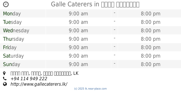
Galle Caterers
122, කඩවත පාර
Food
read more
1.178 km
Bombay Sweet Mart
Colombo
Food
read more
1.313 km
Speed Water
No: 52, Robert Gunawardena Mawatha, Colombo
Food
read more
1.316 km
Schákàsz Dessert Bar
56, Stratford Avenue, Colombo
Food
read more
1.337 km
Nimrasa -නිම් රස හෙළයෙහි රස නිවස
250/3 High Level Road,, Colombo
Food
read more
1.36 km
Boon Chat Juice Corner
Dutugemunu Street, Kohuwala
Food
read more
1.5 km
Bombay Sweet Court
189, A2, Dehiwala-Mount Lavinia
Food
read more
1.55 km
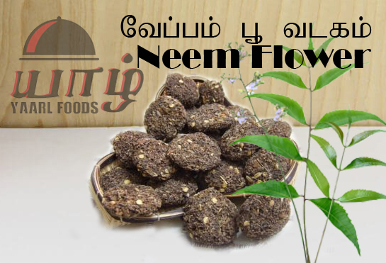
Yaarl Foods
No 11A, Manning Place, Colombo
Food
read more
1.687 km
Aldis Foods
153 Galle Road, Colombo 06
Food
read more
1.697 km
Eat Gram Store
Jayathilaka, Dehiwala-Mount Lavinia
Food
read more
1.721 km
The Zuls Water Systems
494A Havelock Road, Colombo
Food
read more
1.829 km
Beverage Corner
99 South De S. Jayasinghe Mawatha, Nugegoda
Food
read more
1.831 km
Sadana Trade Center
Nedimala
Food
read more
1.846 km
Meaty Meat PVT LTD
Kawdana, East
Food
read more
1.886 km
Worthwild Aquarium
Gangodawila, Nugegoda
Food
read more
1.919 km
Geotech (Pvt) Limited
13/1, Papiliyana Mawatha, Nugegoda
Food
read more
2.096 km
Bombay Sweet Mart
40 b Etul Kotte-Mirihana-Kohuwela Road, Nugegoda
Food
read more
2.311 km
The Happy Baker
60A 1/1, B94, Dehiwala-Mount Lavinia
Food
read more
📑
all categories
Accounting
Administrative area level 1
Administrative area level 2
Airport
Amusement park
Aquarium
Art gallery
Atm
Bakery
Bank
Bar
Beauty salon
Bicycle store
Book store
Bowling alley
Bus station
Cafe
Campground
Car dealer
Car rental
Car repair
Car wash
Casino
Cemetery
Church
City hall
Clothing store
Colloquial area
Convenience store
Country
Courthouse
Dentist
Department store
Doctor
Electrician
Electronics store
Embassy
Finance
Fire station
Florist
Food
Funeral home
Furniture store
Gas station
General contractor
Grocery or supermarket
Gym
Hair care
Hardware store
Health
Hindu Temple
Home goods store
Hospital
Insurance agency
Intersection
Jewelry store
Laundry
Lawyer
Library
Light rail station
Liquor store
Local government office
Locality
Locksmith
Lodging
Meal delivery
Meal takeaway
Mosque
Movie rental
Movie theater
Moving company
Museum
Natural feature
Neighborhood
Night club
Painter
Park
Parking
Pet store
Pharmacy
Physiotherapist
Place of worship
Plumber
Point of interest
Police
Political
Post office
Premise
Real estate agency
Restaurant
Roofing contractor
Route
Rv park, camping
School
Shoe store
Shopping mall
Spa
Stadium
Storage
Store
Subpremise
Supermarket
Synagogue
Taxi stand
Train station
Transit station
Travel agency
University
Veterinary care
Zoo
administrative area level 3
sublocality level 1
sublocality level 2
↑