Food nearby Deshan Stores
Sri Lanka
Food nearby Deshan Stores
Deshan Stores
Bataliya, Sri Lanka
contacts phone
:
+94 332 284 129
Latitude:
7.18516
, Longitude:
80.128083
larger map & directions
read more
nearest Food
421 m
Bolankanda Farm
A1, Kajugama
Food
read more
1.242 km
Ranji Vegetables
Veyangoda
Food
read more
1.668 km
Marhaba Farm Shop
Weerasurikanda Road, Nabuluwa
Food
read more
1.798 km
Sevena Industries (Pvt.) Ltd.
Weerasurikanda Road, Nabuluwa
Food
read more
1.802 km
jayathilaka grocery
Nabuluwa
Food
read more
2.533 km
Usama Traders
Abdul Carder Mawatha
Food
read more
4.947 km
Highland Outlet
Pasyala - Giriulla Road, Loluwagoda
Food
read more
4.973 km
Supipi Industries
Horagasmankada,Danowita, A1, Horagasmankada
Food
read more
5.03 km
Ranaweera Hotel
Pasyala - Giriulla Road, Mirigama
Food
read more
5.042 km
Janatha sweets
no 57,Madabavita,Danovita
Food
read more
5.064 km
My Juice Bar
Gampaha
Food
read more
5.889 km
Juizz Bar
Nittambuwa
Food
read more
5.986 km
Siyane stores
Nittambuwa
Food
read more
6.491 km
ILONKA ILONKA
Negombo - Mirigama Road, Mirigama
Food
read more
6.493 km
Rasoja Food Products (Pvt) Ltd.
Wathupitiwala - Maimbula - Ellakkala Road, Wathupitiwala
Food
read more
7.772 km
JanRich Foods Ltd
Wathupitiwela Kiththammahara Road, Wathupitiwala
Food
read more
8.144 km
Feed Caterers
Gampaha
Food
read more
9.734 km
Acqua Pet Lanka
282 B19, Urapola
Food
read more
11.4 km
Aussee Oats Milling Pvt Ltd
Sri Lanka
Food
read more
11.79 km
Sandathilina Stores
Kalagedihena
Food
read more
11.883 km
Lal poultry Farm
Ruwanpura Kanattha Road
Food
read more
13.285 km
Dikkanda Plantation (Pvt) Ltd.
Sri Lanka
Food
read more
17.201 km
Wije Stores
No-31,Narammala Road,, Alawwa
Food
read more
18.055 km
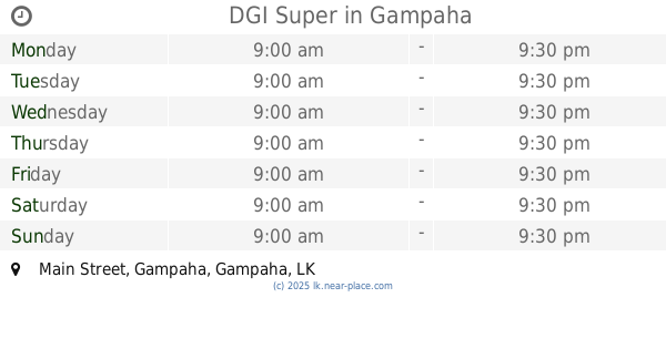
DGI Super
Main Street, Gampaha
Food
read more
18.444 km
Lady Of Lourdes Poultry Breeding Farm
Badalgama
Food
read more
📑
all categories
Accounting
Administrative area level 1
Administrative area level 2
Airport
Amusement park
Aquarium
Art gallery
Atm
Bakery
Bank
Bar
Beauty salon
Bicycle store
Book store
Bowling alley
Bus station
Cafe
Campground
Car dealer
Car rental
Car repair
Car wash
Casino
Cemetery
Church
City hall
Clothing store
Colloquial area
Convenience store
Country
Courthouse
Dentist
Department store
Doctor
Electrician
Electronics store
Embassy
Finance
Fire station
Florist
Food
Funeral home
Furniture store
Gas station
General contractor
Grocery or supermarket
Gym
Hair care
Hardware store
Health
Hindu Temple
Home goods store
Hospital
Insurance agency
Intersection
Jewelry store
Laundry
Lawyer
Library
Light rail station
Liquor store
Local government office
Locality
Locksmith
Lodging
Meal delivery
Meal takeaway
Mosque
Movie rental
Movie theater
Moving company
Museum
Natural feature
Neighborhood
Night club
Painter
Park
Parking
Pet store
Pharmacy
Physiotherapist
Place of worship
Plumber
Point of interest
Police
Political
Post office
Premise
Real estate agency
Restaurant
Roofing contractor
Route
Rv park, camping
School
Shoe store
Shopping mall
Spa
Stadium
Storage
Store
Subpremise
Supermarket
Synagogue
Taxi stand
Train station
Transit station
Travel agency
University
Veterinary care
Zoo
administrative area level 3
sublocality level 1
sublocality level 2
↑