Food nearby Kaipoogalla Tea factory
Sri Lanka
Food nearby Kaipoogalla Tea factory
Kaipoogalla Tea factory
Pundaluoya, Sri Lanka
contacts phone
:
+94
Latitude:
7.0080784
, Longitude:
80.6535728
larger map & directions
read more
nearest Food
17 m
Fernlands Estate
Pundaluoya
Food
read more
1.276 km
Hevanwewa Tea Factory
Pundaluoya
Food
read more
1.654 km
SGM Food Products
Tawalantenne - Talawakele Road, Pundaluoya
Food
read more
1.654 km
SGM Food Products
B412, Pundaluoya
Food
read more
2.227 km
Kubaloluwa Tea Factory
Pundaluoya - Paluwatte Road
Food
read more
2.314 km
North Punduloya Tea Factory
Pundaluoya
Food
read more
2.408 km
Sheen Estate
Nuwara Eliya
Food
read more
3.135 km
Meddecombra Estate
Nuwara Eliya
Food
read more
3.955 km
Belton Estate Pvt.Ltd
Nuwara Eliya
Food
read more
4.693 km
Dunsinane Estate
Distrito de Nuwara Eliya
Food
read more
4.693 km
Dunsinane Estate
Nuwara Eliya
Food
read more
6.242 km
Blue Field Tea Factory
Ramboda, Nuwara Eliya
Food
read more
6.49 km
Milk Collection Centre
Nuwara Eliya
Food
read more
7.42 km
Glenloch Tea Factory
Ramboda New Tunnel Road, Ramboda
Food
read more
7.904 km
Thalawakele Tea Factory
Talawakelle
Food
read more
8.412 km
SHA Catering
kudaoya labukelle, A5
Food
read more
10.201 km
Helbodde Tea Factory
Sri Lanka
Food
read more
12.693 km
Iona Trader
Nuwara Eliya
Food
read more
12.708 km
Mariyas
Nuwara Eliya
Food
read more
13.127 km
Ceylon Fishing Club Circuit Bungalow
Rahula Road, Nuwara Eliya
Food
read more
13.216 km
Donside Tea Factory
Nawalapitiya - Harangala Road
Food
read more
13.767 km
Galboda tea factory
Galboda
Food
read more
14.169 km
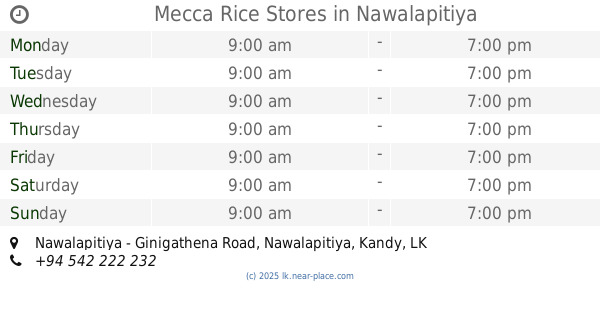
Mecca Rice Stores
Nawalapitiya - Ginigathena Road, Nawalapitiya
Food
read more
15.587 km
Dickoya Tea Factory
Dick oya
Food
read more
17.906 km
Osborne Estate
Hatton
Food
read more
📑
all categories
Accounting
Administrative area level 1
Administrative area level 2
Airport
Amusement park
Aquarium
Art gallery
Atm
Bakery
Bank
Bar
Beauty salon
Bicycle store
Book store
Bowling alley
Bus station
Cafe
Campground
Car dealer
Car rental
Car repair
Car wash
Casino
Cemetery
Church
City hall
Clothing store
Colloquial area
Convenience store
Country
Courthouse
Dentist
Department store
Doctor
Electrician
Electronics store
Embassy
Finance
Fire station
Florist
Food
Funeral home
Furniture store
Gas station
General contractor
Grocery or supermarket
Gym
Hair care
Hardware store
Health
Hindu Temple
Home goods store
Hospital
Insurance agency
Intersection
Jewelry store
Laundry
Lawyer
Library
Light rail station
Liquor store
Local government office
Locality
Locksmith
Lodging
Meal delivery
Meal takeaway
Mosque
Movie rental
Movie theater
Moving company
Museum
Natural feature
Neighborhood
Night club
Painter
Park
Parking
Pet store
Pharmacy
Physiotherapist
Place of worship
Plumber
Point of interest
Police
Political
Post office
Premise
Real estate agency
Restaurant
Roofing contractor
Route
Rv park, camping
School
Shoe store
Shopping mall
Spa
Stadium
Storage
Store
Subpremise
Supermarket
Synagogue
Taxi stand
Train station
Transit station
Travel agency
University
Veterinary care
Zoo
administrative area level 3
sublocality level 1
sublocality level 2
↑