Food nearby Kurumba
Sri Lanka
Food nearby Kurumba
Kurumba
427, Elvitigala Mawatha, 00500, Colombo, Colombo, LK Sri Lanka
contacts phone
:
+94 71 848 9979
Latitude:
6.8956079
, Longitude:
79.8772416
larger map & directions
read more
nearest Food
81 m
Femstar Entertainers
No 420, Elvitigala Mawatha, Colombo 05, Sri Lanka, Colombo 05
Food
read more
328 m
Lucky Kiri Katha - Narahenpita
Kirula, Colombo
Food
read more
387 m
David Gram Stores
Colombo
Food
read more
416 m
NLDB Milk Bar
Kirula, Colombo
Food
read more
816 m
Vilasa Cottage Food Court
Majestic City, Food Court, Colombo
Food
read more
842 m
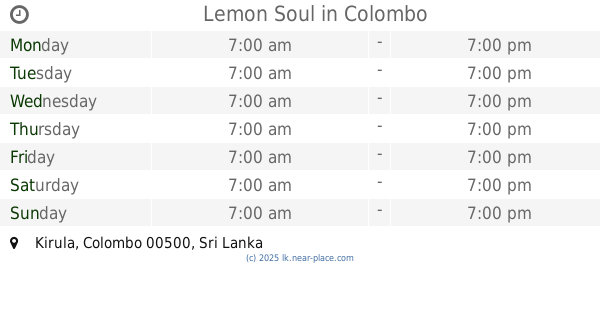
Lemon Soul
Kirula, Colombo
Food
read more
849 m
Rockland Distilleries (Pvt) Ltd
Kirimandala Mawatha, Colombo
Food
read more
988 m
Maxies Chicken
123a Narahenpita Road, Colombo
Food
read more
1.011 km
Open University
Colombo
Food
read more
1.04 km
A Hint of Spice
46/2 Fife Road, Colombo
Food
read more
1.084 km
RentIT
No.26,, Fife Road,, Colombo
Food
read more
1.084 km
The Sausage Shop
125, Fife Road,, Colombo 5.
Food
read more
1.433 km
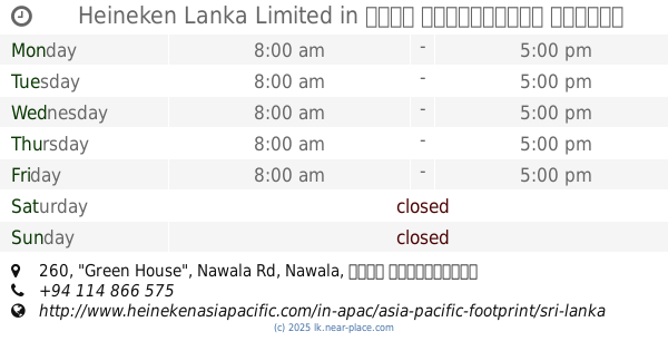
Heineken Lanka Limited
260, "Green House", Nawala Rd, Nawala
Food
read more
1.484 km
Soul Coffee
D. S, 35 De Fonseka Road, Colombo
Food
read more
1.5 km
Na Tree Caterers Pvt Ltd
No 93/2 A Old Road, Nawala
Food
read more
1.598 km
Ravi Investment
Dharmarama Road, Colombo
Food
read more
1.877 km
The Zuls Water Systems
494A Havelock Road, Colombo
Food
read more
1.878 km
Fresheez
Colombo
Food
read more
1.891 km
Salo's
104/5 Senanayake Ave, Nawala, Rajagiriya.
Food
read more
1.91 km
Oceanpick Pvt Ltd
00800, No. 20, Shady Grove Avenue, Colombo
Food
read more
1.91 km
Oceanpick (Pvt) Ltd
No. 20 Shady Grove Ave, 00800,, Colombo
Food
read more
1.974 km
De Lite
Elibank Road, Colombo
Food
read more
1.988 km
Reviva Teas Pvt Ltd
Pamankada West, Colombo
Food
read more
2.091 km
Organic baby food Sri Lanka
122 Cotta Road, Borella , Colombo 8
Food
read more
2.218 km
Cargills Food City
Kurunduwatta, Colombo
Food
read more
📑
all categories
Accounting
Administrative area level 1
Administrative area level 2
Airport
Amusement park
Aquarium
Art gallery
Atm
Bakery
Bank
Bar
Beauty salon
Bicycle store
Book store
Bowling alley
Bus station
Cafe
Campground
Car dealer
Car rental
Car repair
Car wash
Casino
Cemetery
Church
City hall
Clothing store
Colloquial area
Convenience store
Country
Courthouse
Dentist
Department store
Doctor
Electrician
Electronics store
Embassy
Finance
Fire station
Florist
Food
Funeral home
Furniture store
Gas station
General contractor
Grocery or supermarket
Gym
Hair care
Hardware store
Health
Hindu Temple
Home goods store
Hospital
Insurance agency
Intersection
Jewelry store
Laundry
Lawyer
Library
Light rail station
Liquor store
Local government office
Locality
Locksmith
Lodging
Meal delivery
Meal takeaway
Mosque
Movie rental
Movie theater
Moving company
Museum
Natural feature
Neighborhood
Night club
Painter
Park
Parking
Pet store
Pharmacy
Physiotherapist
Place of worship
Plumber
Point of interest
Police
Political
Post office
Premise
Real estate agency
Restaurant
Roofing contractor
Route
Rv park, camping
School
Shoe store
Shopping mall
Spa
Stadium
Storage
Store
Subpremise
Supermarket
Synagogue
Taxi stand
Train station
Transit station
Travel agency
University
Veterinary care
Zoo
administrative area level 3
sublocality level 1
sublocality level 2
↑