Food nearby Mini Co-Op City
Sri Lanka
Food nearby Mini Co-Op City
Mini Co-Op City
Kahelbaddara, Sri Lanka
contacts phone
:
+94
Latitude:
7.122542
, Longitude:
79.966421
larger map & directions
read more
nearest Food
47 m
Ravidu Cashew (රවිදු කජු සල)
Kahelbaddara
Food
read more
1.082 km
Vithana Cashew
Batapotha
Food
read more
2.04 km
asiri food factory
Nedagamuwa
Food
read more
2.429 km
RKR Vegetable
Makewita Road
Food
read more
3.251 km
Sri Lanka Cashew Corporation
Kaluwelgoda, Makewita, Batapotha-Makewita Road
Food
read more
3.4 km
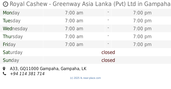
Royal Cashew - Greenway Asia Lanka (Pvt) Ltd
60, A33, Gampaha
Food
read more
3.56 km
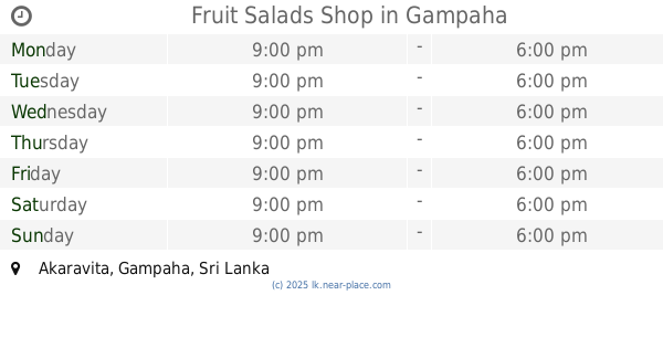
Fruit Salads Shop
Akaravita, Gampaha
Food
read more
3.661 km
Royal Cashew Factory
Sri Lanka
Food
read more
3.679 km
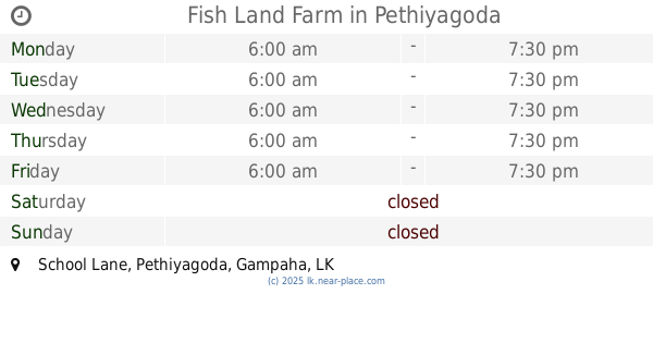
Fish Land Farm
School Lane, Pethiyagoda
Food
read more
3.912 km
kanchana Storse
31 A, 31 A B225
Food
read more
4.251 km
Milk Collection Centre
Fonterra Brands Lanka - GMCC, Doranagoda Rd
Food
read more
4.372 km
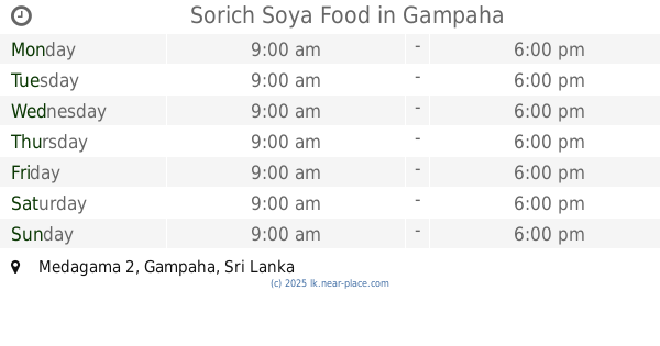
Sorich Soya Food
Medagama 2, Gampaha
Food
read more
4.514 km
Cake classes By Sandya
Medagama 2, Gampaha
Food
read more
4.532 km
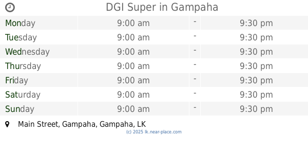
DGI Super
Main Street, Gampaha
Food
read more
4.604 km
Global enterprises (Pvt) Ltd
Minuwangoda
Food
read more
4.701 km
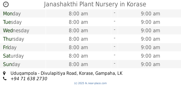
Janashakthi Plant Nursery
Udugampola - Divulapitiya Road, Korase
Food
read more
4.708 km
Juice Bar
Medagama 4, Gampaha
Food
read more
4.816 km
Seeds Bread King
Medagama 1, Gampaha
Food
read more
4.85 km
Mellona Chocolate Cafe
Shop 10, Ward City Shopping Complex, Marybiso Road, Gampaha
Food
read more
5.045 km
Nethmi Foods Centre
No : 149/3, Aluthgama
Food
read more
5.446 km
Janitha Bakers
364 Minuwangoda-Gampaha-Miriswatta Road, Gampaha
Food
read more
5.627 km
King Food Caterers
808F, Yakkaduwa, Ja-Ela
Food
read more
5.988 km
Bottled Drinking Water BINAL DISTRIBUTORS
Minuwangoda-Gampaha-Miriswatta Road, Gampaha
Food
read more
6.077 km
Produce of Paradise (pvt.) Ltd
Sri Lanka
Food
read more
6.086 km
Produce of Paradise (pvt.) Ltd
139 Polwaththa Road, Kalahugoda, Minuangoda
Food
read more
📑
all categories
Accounting
Administrative area level 1
Administrative area level 2
Airport
Amusement park
Aquarium
Art gallery
Atm
Bakery
Bank
Bar
Beauty salon
Bicycle store
Book store
Bowling alley
Bus station
Cafe
Campground
Car dealer
Car rental
Car repair
Car wash
Casino
Cemetery
Church
City hall
Clothing store
Colloquial area
Convenience store
Country
Courthouse
Dentist
Department store
Doctor
Electrician
Electronics store
Embassy
Finance
Fire station
Florist
Food
Funeral home
Furniture store
Gas station
General contractor
Grocery or supermarket
Gym
Hair care
Hardware store
Health
Hindu Temple
Home goods store
Hospital
Insurance agency
Intersection
Jewelry store
Laundry
Lawyer
Library
Light rail station
Liquor store
Local government office
Locality
Locksmith
Lodging
Meal delivery
Meal takeaway
Mosque
Movie rental
Movie theater
Moving company
Museum
Natural feature
Neighborhood
Night club
Painter
Park
Parking
Pet store
Pharmacy
Physiotherapist
Place of worship
Plumber
Point of interest
Police
Political
Post office
Premise
Real estate agency
Restaurant
Roofing contractor
Route
Rv park, camping
School
Shoe store
Shopping mall
Spa
Stadium
Storage
Store
Subpremise
Supermarket
Synagogue
Taxi stand
Train station
Transit station
Travel agency
University
Veterinary care
Zoo
administrative area level 3
sublocality level 1
sublocality level 2
↑