Food nearby Ovins Food Cafe
Sri Lanka
Food nearby Ovins Food Cafe
Ovins Food Cafe
pannipitiya road, palam, thuna junction, Pannipitiya, Sri Lanka
contacts phone
:
+94
Latitude:
6.8946509
, Longitude:
79.9249366
larger map & directions
read more
nearest Food
7 m
Pelawatta Chicken Shop
Pelawatte
Food
read more
243 m
Orange&Lime
Pelawatte, Battaramulla
Food
read more
382 m
Pelawatta Juice Bar
Pannipitiya Road, Sri Jayawardenepura Kotte
Food
read more
492 m
Landa Juice Bar
110 Parliament Road, Sri Jayawardenepura Kotte
Food
read more
523 m
Co-op Milk Bar
B47, Battaramulla
Food
read more
547 m
Rachitha Stores
110 Parliament Road, Sri Jayawardenepura Kotte
Food
read more
802 m
Rajarata Nawum Palathuru
763 B47, Sri Jayawardenepura Kotte
Food
read more
814 m
Jungle Juice
B47, Sri Jayawardenepura Kotte
Food
read more
832 m
Diyawanna Food Court
Inner Ring Road, Sri Jayawardenepura Kotte
Food
read more
933 m
Pussalla Meat Shop
950/3 B47, Battaramulla
Food
read more
961 m
Green Go
B47, Sri Jayawardenepura Kotte
Food
read more
983 m
Battaramulla Meat Shops
Battaramulla
Food
read more
1.097 km
Seleena Food Court
Batapotha
Food
read more
1.125 km
Cargols Food City
Rajamalwatta
Food
read more
1.128 km
Surasa Caters
Battaramulla
Food
read more
1.209 km
Access Natural Water (Pvt) Ltd
78 Rajamalwate Road, Sri Jayawardenepura Kotte
Food
read more
1.233 km
Fresh Juice Shop
Battaramulla
Food
read more
1.275 km
Sirilak Sea Food Store
AB15 AB15, Sri Jayawardenepura Kotte
Food
read more
1.324 km
Juice bar
Subuthipura, Battaramulla
Food
read more
1.855 km
Dilanka Food Center
Forest Drive, Sri Jayawardenepura Kotte
Food
read more
2.012 km
Despro Products
71, Vijithapura, Thalawatugoda Road
Food
read more
2.194 km
Ahinsa Tea
148/1 Thalawathugoda Road, Pita Kotte, Colombo Pita Kotte
Food
read more
2.205 km
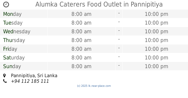
Alumka Caterers Food Outlet
Pannipitiya
Food
read more
2.269 km
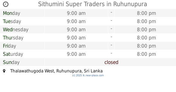
Sithumini Super Traders
Thalawathugoda West, Ruhunupura
Food
read more
2.276 km
Kumarage Traders
Battaramulla - Pannipitiya Road, Ruhunupura
Food
read more
📑
all categories
Accounting
Administrative area level 1
Administrative area level 2
Airport
Amusement park
Aquarium
Art gallery
Atm
Bakery
Bank
Bar
Beauty salon
Bicycle store
Book store
Bowling alley
Bus station
Cafe
Campground
Car dealer
Car rental
Car repair
Car wash
Casino
Cemetery
Church
City hall
Clothing store
Colloquial area
Convenience store
Country
Courthouse
Dentist
Department store
Doctor
Electrician
Electronics store
Embassy
Finance
Fire station
Florist
Food
Funeral home
Furniture store
Gas station
General contractor
Grocery or supermarket
Gym
Hair care
Hardware store
Health
Hindu Temple
Home goods store
Hospital
Insurance agency
Intersection
Jewelry store
Laundry
Lawyer
Library
Light rail station
Liquor store
Local government office
Locality
Locksmith
Lodging
Meal delivery
Meal takeaway
Mosque
Movie rental
Movie theater
Moving company
Museum
Natural feature
Neighborhood
Night club
Painter
Park
Parking
Pet store
Pharmacy
Physiotherapist
Place of worship
Plumber
Point of interest
Police
Political
Post office
Premise
Real estate agency
Restaurant
Roofing contractor
Route
Rv park, camping
School
Shoe store
Shopping mall
Spa
Stadium
Storage
Store
Subpremise
Supermarket
Synagogue
Taxi stand
Train station
Transit station
Travel agency
University
Veterinary care
Zoo
administrative area level 3
sublocality level 1
sublocality level 2
↑