Food nearby Perumal-Yarlco
Sri Lanka
Food nearby Perumal-Yarlco
Perumal-Yarlco
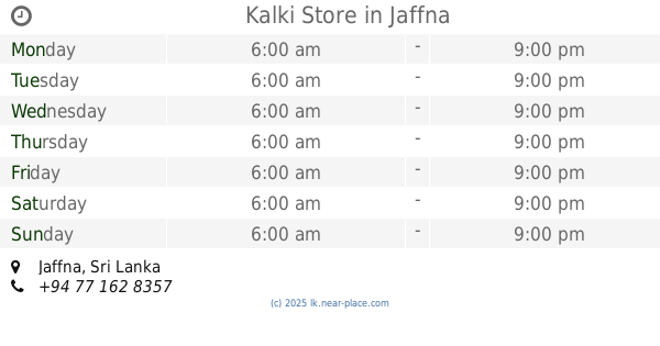
Jaffna, Sri Lanka
contacts phone
:
+94
Latitude:
9.6718797
, Longitude:
80.016299
larger map & directions
read more
nearest Food
275 m
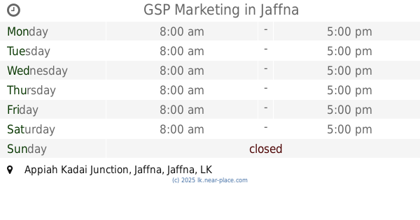
GSP Marketing
Appiah Kadai Junction, Jaffna
Food
read more
651 m
American water
Jaffna
Food
read more
719 m
Jayam Cool Bar
No.133, Jaffna
Food
read more
775 m
New Theensuvai Mixture
No 238, Jaffna-Kankesanturai Road, Kokkuvil
Food
read more
834 m
Anna Kopi
Jaffna
Food
read more
871 m
R.Sivslingam Fruits Centre
C Ponnampalam Road, Jaffna
Food
read more
977 m
Sri Sivaram Traders
No.248, Hospital Road, 021-2228629, Jaffna
Food
read more
1.024 km
Pillaijar Mill
Jaffna
Food
read more
1.13 km
Omkara Stores
No. 06, Rakka Road, Jaffna
Food
read more
1.295 km
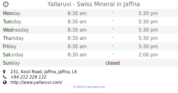
Yallaruvi - Swiss Mineral
யாழருவி - சுவிஸ்மினரல், 231 Kovil Road, Jaffna
Food
read more
1.627 km
Yalco milk product
AB20, Jaffna
Food
read more
1.838 km
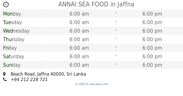
ANNAI SEA FOOD
Beach Road, Jaffna
Food
read more
1.949 km
Reclamation Ice Factory
Jaffna
Food
read more
2.055 km
Senthurry Juice Corner
788C Point Pedro Road, Jaffna
Food
read more
2.283 km
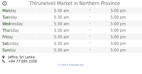
Thirunelveli Market
Food
read more
2.621 km
Seer Biophonics Farms
51/3, Potpathy Road, Kokuvil East, Jaffna
Food
read more
2.621 km
Seer Bio-Phonics Farms
51/3, Potpathy Road, Kokuvil East, Jaffna
Food
read more
2.749 km
Kalki Store
Jaffna
Food
read more
2.799 km
Seafood Exporters
Jaffna
Food
read more
3.126 km
Sharon sea food exporters
62,Vithanes lane, Jaffna
Food
read more
3.204 km
Yargo milk city
Jaffna
Food
read more
4.496 km
Thurkkas Mixture Industries
School lane,, Kondavil West, Kondavil, Jaffna
Food
read more
5.504 km
Selvan Stores & Veg Market
Jaffna
Food
read more
6.399 km
Kannan Hen Farm
Dżafna
Food
read more
6.399 km
Kannan Hen Farm
Jaffna
Food
read more
📑
all categories
Accounting
Administrative area level 1
Administrative area level 2
Airport
Amusement park
Aquarium
Art gallery
Atm
Bakery
Bank
Bar
Beauty salon
Bicycle store
Book store
Bowling alley
Bus station
Cafe
Campground
Car dealer
Car rental
Car repair
Car wash
Casino
Cemetery
Church
City hall
Clothing store
Colloquial area
Convenience store
Country
Courthouse
Dentist
Department store
Doctor
Electrician
Electronics store
Embassy
Finance
Fire station
Florist
Food
Funeral home
Furniture store
Gas station
General contractor
Grocery or supermarket
Gym
Hair care
Hardware store
Health
Hindu Temple
Home goods store
Hospital
Insurance agency
Intersection
Jewelry store
Laundry
Lawyer
Library
Light rail station
Liquor store
Local government office
Locality
Locksmith
Lodging
Meal delivery
Meal takeaway
Mosque
Movie rental
Movie theater
Moving company
Museum
Natural feature
Neighborhood
Night club
Painter
Park
Parking
Pet store
Pharmacy
Physiotherapist
Place of worship
Plumber
Point of interest
Police
Political
Post office
Premise
Real estate agency
Restaurant
Roofing contractor
Route
Rv park, camping
School
Shoe store
Shopping mall
Spa
Stadium
Storage
Store
Subpremise
Supermarket
Synagogue
Taxi stand
Train station
Transit station
Travel agency
University
Veterinary care
Zoo
administrative area level 3
sublocality level 1
sublocality level 2
↑