Food nearby Saliya Stores
Sri Lanka
Food nearby Saliya Stores
Saliya Stores
Bakamuna Sri Lanka
contacts phone
:
+94
Latitude:
7.8414451
, Longitude:
80.8625508
read more
nearest Food
17.414 km
Nuwaragala Seed Processing Center
Nawagahaela
Food
read more
17.924 km
Bhagya Farm Shop
Sigiriya
Food
read more
18.66 km
LG Farm (Pvt) Ltd
C.P. Pura, Minneriya. Sri Lanka., Minneriya
Food
read more
18.789 km
Samya Product
Jayanthipura, Polonnaruwa
Food
read more
19.365 km
Cool park
Maradankadawala-Habarana-Thirukkondaiadimadu Highway
Food
read more
19.447 km
C.P.K. Bakers
Polonnaruwa
Food
read more
20.259 km
Seed Farm, Polonnaruwe
2nd Canal Road, Polonnaruwa
Food
read more
21.065 km
Wickramarathna Group
467-626 Maradankadawala-Habarana-Thirukkondaiadimadu Highway, Polonnaruwa
Food
read more
21.334 km
Seeds And Planting Matirials Sales Center
Polonnaruwa
Food
read more
22.405 km
Fresheez By CIC
habaran road
Food
read more
22.895 km
Rathnayaka Stores
Kandy - Jaffna Highway, Dambulla
Food
read more
22.895 km
Rathnayaka Stores
A9, Dambulla
Food
read more
23.298 km
New Mahaweli Curd Shop
Gallella
Food
read more
23.398 km
S L Traders
Dambulla
Food
read more
23.415 km
Jayalanka Treaders
A-2-1Dedicated Economic Center, Dambulla
Food
read more
23.434 km
Wanewatta Trade Centre
Dambulla
Food
read more
23.452 km
Juice Bar
Dambulla
Food
read more
23.688 km
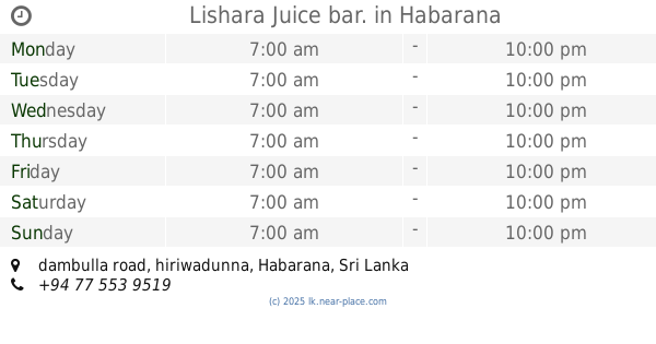
Lisara Juice bar.
dambulla road, hiriwadunna, Habarana
Food
read more
23.688 km
Lishara Juice bar.
dambulla road, hiriwadunna, Habarana
Food
read more
23.896 km
Helabojun
Dambulla
Food
read more
25.281 km
Eco planet
Kandy - Jaffna Highway
Food
read more
27.332 km
Ambana Agro Chemicals
Kandy - Jaffna Highway, Naula
Food
read more
27.336 km
Sarubima Agri Services
Kandy - Jaffna Highway, Naula
Food
read more
28.122 km
Praja Sanda Diyawara water project
bihirisorowwa, Bandanagala
Food
read more
34.739 km
HILLLAND ENTERPRISES
Nalanda indrustial park Ulpotha,, Madawala Ulpotha
Food
read more
📑
all categories
Accounting
Administrative area level 1
Administrative area level 2
Airport
Amusement park
Aquarium
Art gallery
Atm
Bakery
Bank
Bar
Beauty salon
Bicycle store
Book store
Bowling alley
Bus station
Cafe
Campground
Car dealer
Car rental
Car repair
Car wash
Casino
Cemetery
Church
City hall
Clothing store
Colloquial area
Convenience store
Country
Courthouse
Dentist
Department store
Doctor
Electrician
Electronics store
Embassy
Finance
Fire station
Florist
Food
Funeral home
Furniture store
Gas station
General contractor
Grocery or supermarket
Gym
Hair care
Hardware store
Health
Hindu Temple
Home goods store
Hospital
Insurance agency
Intersection
Jewelry store
Laundry
Lawyer
Library
Light rail station
Liquor store
Local government office
Locality
Locksmith
Lodging
Meal delivery
Meal takeaway
Mosque
Movie rental
Movie theater
Moving company
Museum
Natural feature
Neighborhood
Night club
Painter
Park
Parking
Pet store
Pharmacy
Physiotherapist
Place of worship
Plumber
Point of interest
Police
Political
Post office
Premise
Real estate agency
Restaurant
Roofing contractor
Route
Rv park, camping
School
Shoe store
Shopping mall
Spa
Stadium
Storage
Store
Subpremise
Supermarket
Synagogue
Taxi stand
Train station
Transit station
Travel agency
University
Veterinary care
Zoo
administrative area level 3
sublocality level 1
sublocality level 2
↑