Food nearby Tembalstor Tea Fectory.
Sri Lanka
Food nearby Tembalstor Tea Fectory.
Tembalstor Tea Fectory.
Rozella Station Road, Kandy, Central Province, LK Sri Lanka
contacts phone
:
+94 72 886 1578
Latitude:
6.9501154
, Longitude:
80.5527988
larger map & directions
read more
nearest Food
3.558 km
Mount Jean Estate , Watawala
Galboda
Food
read more
4.729 km
Galboda tea factory
Galboda
Food
read more
4.735 km
Strathdon Tea Factory
Nuwara Eliya
Food
read more
4.751 km
Gallebodde Estate , Galbodde
Galboda
Food
read more
5.744 km
Shanon Tea Factory
Hatton
Food
read more
7.838 km
Osborne Estate
Hatton
Food
read more
7.93 km
Mihiranga Stores
Unnamed Road, Ginigathhena
Food
read more
9.419 km
harangala tea factory
Kotmale
Food
read more
9.596 km
Dickoya Tea Factory
Dick oya
Food
read more
10.566 km
Wanarajah Tea Factory
Wanaraja Tea Factory, Hatton - Maskeliya - Dalhousie Road, Hatton
Food
read more
10.567 km
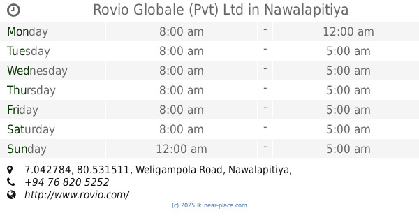
Rovio Globale (Pvt) Ltd
7.042784, 80.531511, Weligampola Road, Nawalapitiya
Food
read more
11.705 km
Thalawakele Tea Factory
Talawakelle
Food
read more
11.713 km
Amma's Sujanith Food Products
Baily Road, Nawalapitiya
Food
read more
11.837 km
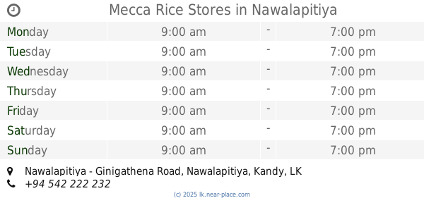
Mecca Rice Stores
Nawalapitiya - Ginigathena Road, Nawalapitiya
Food
read more
11.863 km
Battalgalla Estate
Dick oya
Food
read more
12.87 km
Fernlands Estate
Pundaluoya
Food
read more
12.908 km
B & S Juice bar
Kandy
Food
read more
12.924 km
Donside Tea Factory
Nawalapitiya - Harangala Road
Food
read more
13.539 km
Laxapana Estate
Nuwara Eliya
Food
read more
13.722 km
Gorokoya Tea Factory
Gorokoya Maha Vidyalaya, Nawalapitiya - Harangala Road, Nuwara Eliya
Food
read more
14.64 km
Tilton tea factory
Pallegama
Food
read more
14.659 km
Kubaloluwa Tea Factory
Pundaluoya - Paluwatte Road
Food
read more
15.016 km
Kamalam Chemicals
Nuwara Eliya Road, Lindula, Avissawella-Hatton-Nuwara Eliya Highway
Food
read more
16.583 km
Thushara Kithul Foods Products
Nuwara Eliya
Food
read more
17.328 km
Torrington Estate
Nuwara Eliya
Food
read more
📑
all categories
Accounting
Administrative area level 1
Administrative area level 2
Airport
Amusement park
Aquarium
Art gallery
Atm
Bakery
Bank
Bar
Beauty salon
Bicycle store
Book store
Bowling alley
Bus station
Cafe
Campground
Car dealer
Car rental
Car repair
Car wash
Casino
Cemetery
Church
City hall
Clothing store
Colloquial area
Convenience store
Country
Courthouse
Dentist
Department store
Doctor
Electrician
Electronics store
Embassy
Finance
Fire station
Florist
Food
Funeral home
Furniture store
Gas station
General contractor
Grocery or supermarket
Gym
Hair care
Hardware store
Health
Hindu Temple
Home goods store
Hospital
Insurance agency
Intersection
Jewelry store
Laundry
Lawyer
Library
Light rail station
Liquor store
Local government office
Locality
Locksmith
Lodging
Meal delivery
Meal takeaway
Mosque
Movie rental
Movie theater
Moving company
Museum
Natural feature
Neighborhood
Night club
Painter
Park
Parking
Pet store
Pharmacy
Physiotherapist
Place of worship
Plumber
Point of interest
Police
Political
Post office
Premise
Real estate agency
Restaurant
Roofing contractor
Route
Rv park, camping
School
Shoe store
Shopping mall
Spa
Stadium
Storage
Store
Subpremise
Supermarket
Synagogue
Taxi stand
Train station
Transit station
Travel agency
University
Veterinary care
Zoo
administrative area level 3
sublocality level 1
sublocality level 2
↑