Food nearby Woodside Old Tea Factory
Sri Lanka
Food nearby Woodside Old Tea Factory
Woodside Old Tea Factory
Rajagala Sri Lanka
contacts phone
:
+94
Latitude:
7.2802348
, Longitude:
80.8273881
read more
nearest Food
2.406 km
Hotel Jayalath
A26, Moragahamula
Food
read more
2.976 km
Udaya Stores
Hunnasgiriya
Food
read more
5.398 km
Thissa Stores - තිස්ස වෙළදසැල
Kiripattiya Road
Food
read more
7.041 km
Dumbara Seven Super
Ududumbara - Madugalla Road, Mediwaka
Food
read more
7.05 km
Abeykoon Stores
Udadumbara
Food
read more
8.196 km
Birty Stores
Karalliyadda
Food
read more
8.289 km
New Kandurata Stores
Karalliyadda
Food
read more
8.344 km
Rangalla Tea Factory
Rangala Road
Food
read more
9.08 km
Adhikarigama Agro
Adhikarigama, Mahaweli Raja Mawatha
Food
read more
9.713 km
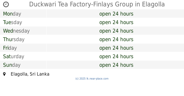
Duckwari Tea Factory-Finlays Group
Elagolla
Food
read more
9.733 km
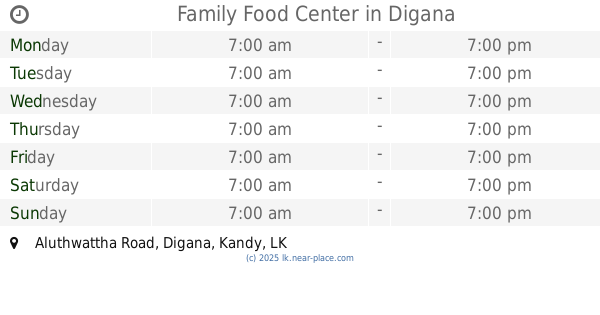
Family Food Center
Aluthwattha Road, Digana
Food
read more
11.966 km
medawatta product
Food
read more
12.645 km
Saman Hotel
Hanguranketa
Food
read more
12.732 km
Kusum Agro
Post Office - Hanguranketha, Tennekumbura-Rikillagaskada-Ragala Highway, Hanguranketa
Food
read more
12.849 km
Upali Agro Center
Hanguranketa
Food
read more
13.517 km
Devi Stores And Grocery
Unnamed Road, Pallekele
Food
read more
13.603 km
Gomara Tea Factory
Gomara,Thawalantenna,
Food
read more
13.938 km
Cargills Kist Knuckles Water Plant
Knuckles Peak Road, Gomara
Food
read more
14.442 km
Canteen
Pallekele
Food
read more
14.584 km
Sunil Food Products
Madawala - Rajawella Road, Menikhinna
Food
read more
15.294 km
Kalyani Papadam Maker & Shop
47 Polambakotuwa Hurikaduwa Menikhinna, Madawala - Rajawella Road, Jambugahapitiya
Food
read more
15.416 km
Lakpohora Regional Store - Rikillagadkada
Kandy Road, Tennekumbura-Rikillagaskada-Ragala Highway, Rikillagaskada
Food
read more
16.925 km
Sampath Rice Mill
Hasalaka
Food
read more
17.807 km
Great Valley Estate
Deltota
Food
read more
18.81 km
Pattiyagama Tea Factory
Deltota
Food
read more
📑
all categories
Accounting
Administrative area level 1
Administrative area level 2
Airport
Amusement park
Aquarium
Art gallery
Atm
Bakery
Bank
Bar
Beauty salon
Bicycle store
Book store
Bowling alley
Bus station
Cafe
Campground
Car dealer
Car rental
Car repair
Car wash
Casino
Cemetery
Church
City hall
Clothing store
Colloquial area
Convenience store
Country
Courthouse
Dentist
Department store
Doctor
Electrician
Electronics store
Embassy
Finance
Fire station
Florist
Food
Funeral home
Furniture store
Gas station
General contractor
Grocery or supermarket
Gym
Hair care
Hardware store
Health
Hindu Temple
Home goods store
Hospital
Insurance agency
Intersection
Jewelry store
Laundry
Lawyer
Library
Light rail station
Liquor store
Local government office
Locality
Locksmith
Lodging
Meal delivery
Meal takeaway
Mosque
Movie rental
Movie theater
Moving company
Museum
Natural feature
Neighborhood
Night club
Painter
Park
Parking
Pet store
Pharmacy
Physiotherapist
Place of worship
Plumber
Point of interest
Police
Political
Post office
Premise
Real estate agency
Restaurant
Roofing contractor
Route
Rv park, camping
School
Shoe store
Shopping mall
Spa
Stadium
Storage
Store
Subpremise
Supermarket
Synagogue
Taxi stand
Train station
Transit station
Travel agency
University
Veterinary care
Zoo
administrative area level 3
sublocality level 1
sublocality level 2
↑