Gas station nearby Chathuranga Wijesuriya
Sri Lanka
Gas station nearby Chathuranga Wijesuriya
Chathuranga Wijesuriya
Katana, Sri Lanka
contacts phone
:
+94 77 727 9814
Latitude:
7.2467957
, Longitude:
79.8940806
larger map & directions
read more
nearest Gas station
548 m
Lanka IOC
Negombo - Giriulla Road
Gas station
read more
2.34 km
St.Anthony's Filling Station
Miriswatte
Gas station
read more
3.55 km
IOC Filling Station
Sri Lanka
Gas station
read more
4.221 km
Sinon Litro Gas
3rd Lane, Negombo
Gas station
read more
4.292 km
Regal Filling Station (PVT) LTD
Toppuwa-Nattandiya-Madampe Road, Dankotuwa
Gas station
read more
4.292 km
Regal Filling Station (PVT) LTD
B419, Dankotuwa
Gas station
read more
4.334 km
Kochchikade Gas Station - IOC
Negombo
Gas station
read more
4.336 km
Joe & Sons
Negombo
Gas station
read more
4.345 km
Filling Station
1, 316/1/1 හලාවත - කොළඹ ප්රධාන පාර
Gas station
read more
4.353 km
Thopputhota Filling Station
Chilaw - Colombo Main Road
Gas station
read more
4.407 km
Lanka Filling Station
Negombo
Gas station
read more
4.429 km
Elight Gas Station - IOC
Negombo
Gas station
read more
4.429 km
Elight Gas Station - IOC
நீர்கொழும்பு
Gas station
read more
4.509 km
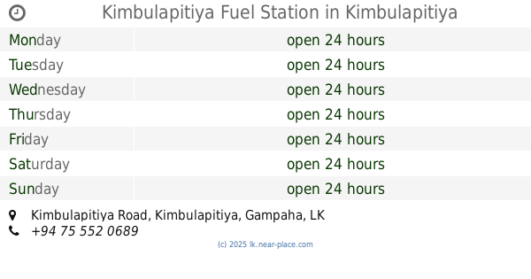
Kimbulapitiya Fuel Station
Kimbulapitiya Road, Kimbulapitiya
Gas station
read more
4.598 km
D.A.W.Tillekeratne Filling Station
Gampaha
Gas station
read more
5.096 km
Lanka Filling Station
Sri Lanka
Gas station
read more
5.315 km
Dalupotha Filling Station
Chilaw - Colombo Main Road, Negombo
Gas station
read more
5.571 km
Litro Gas
Jayarathna Road, Negombo
Gas station
read more
6.017 km
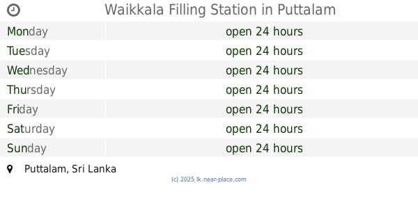
Waikkala Filling Station
Puttalam
Gas station
read more
6.333 km
Ceypetco
Negombo
Gas station
read more
6.598 km
Lanka Fuel
Negombo
Gas station
read more
6.598 km
Lanka Fuel
நீர்கொழும்பு
Gas station
read more
6.603 km
Laugfs Filling Station
Negombo
Gas station
read more
6.946 km
Ceypetco Fuel Station
Negombo
Gas station
read more
13.627 km
Nawa Lanka Sewa Filing Station
Janadhipathi Mawatha, Colombo
Gas station
read more
📑
all categories
Accounting
Administrative area level 1
Administrative area level 2
Airport
Amusement park
Aquarium
Art gallery
Atm
Bakery
Bank
Bar
Beauty salon
Bicycle store
Book store
Bowling alley
Bus station
Cafe
Campground
Car dealer
Car rental
Car repair
Car wash
Casino
Cemetery
Church
City hall
Clothing store
Colloquial area
Convenience store
Country
Courthouse
Dentist
Department store
Doctor
Electrician
Electronics store
Embassy
Finance
Fire station
Florist
Food
Funeral home
Furniture store
Gas station
General contractor
Grocery or supermarket
Gym
Hair care
Hardware store
Health
Hindu Temple
Home goods store
Hospital
Insurance agency
Intersection
Jewelry store
Laundry
Lawyer
Library
Light rail station
Liquor store
Local government office
Locality
Locksmith
Lodging
Meal delivery
Meal takeaway
Mosque
Movie rental
Movie theater
Moving company
Museum
Natural feature
Neighborhood
Night club
Painter
Park
Parking
Pet store
Pharmacy
Physiotherapist
Place of worship
Plumber
Point of interest
Police
Political
Post office
Premise
Real estate agency
Restaurant
Roofing contractor
Route
Rv park, camping
School
Shoe store
Shopping mall
Spa
Stadium
Storage
Store
Subpremise
Supermarket
Synagogue
Taxi stand
Train station
Transit station
Travel agency
University
Veterinary care
Zoo
administrative area level 3
sublocality level 1
sublocality level 2
↑