Gas station nearby CPC Stores
Sri Lanka
Gas station nearby CPC Stores
CPC Stores
Matara, Sri Lanka
contacts phone
:
+94
Latitude:
5.9520931
, Longitude:
80.5447451
larger map & directions
read more
nearest Gas station
445 m
Ceypetco Filling Station
Nilwala By pass, Matara
Gas station
read more
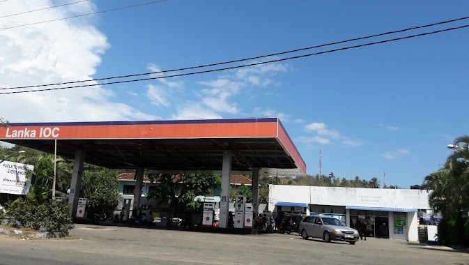
484 m
Lanka IOC Filling Station
No:173,Anagarika Dharmapala Mawatha
Gas station
read more
488 m
Lanka Filling Station Matara
Main Street, Matara
Gas station
read more
610 m
Pinidiya Filling Station
B275, Matara
Gas station
read more
709 m
IOC Filling Station
Matara
Gas station
read more
741 m
Laugfs Gas
Matara
Gas station
read more
1.417 km
SLTB Disel Shed
Matara
Gas station
read more
1.448 km
Pallimulla Fuel Station
Matara
Gas station
read more
1.657 km
Pamburana Filling Station
Main Street, Matara
Gas station
read more
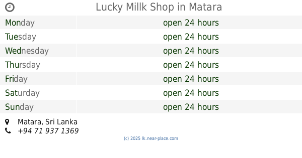
1.896 km
Lucky Millk Shop
Matara
Gas station
read more
10.047 km
Yatiyana Fuel Station
Sri Lanka
Gas station
read more
10.77 km
Denipitiya Fuel Station
Denipitiya, Weligama
Gas station
read more
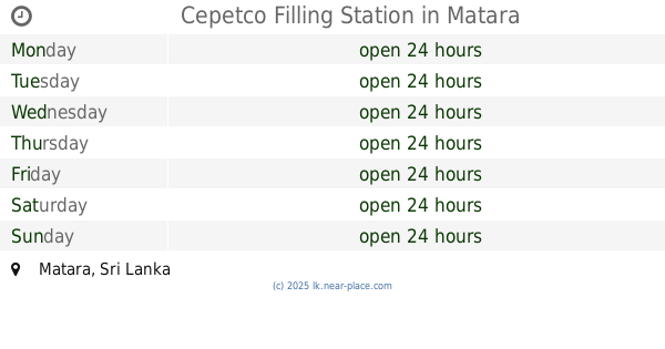
10.787 km
Cepetco Filling Station
Matara
Gas station
read more
10.787 km
Ceypetco Filling Station
Matara
Gas station
read more
12.183 km
Hunnadeniya Filling Station
Tangalle Road, Maaliyadda
Gas station
read more
12.844 km
Weligama Filling Station
Weligama
Gas station
read more
13.11 km
Filling Station
Weligama By Pass Road
Gas station
read more
13.517 km
Darshana Food City
A24, Algiriya
Gas station
read more
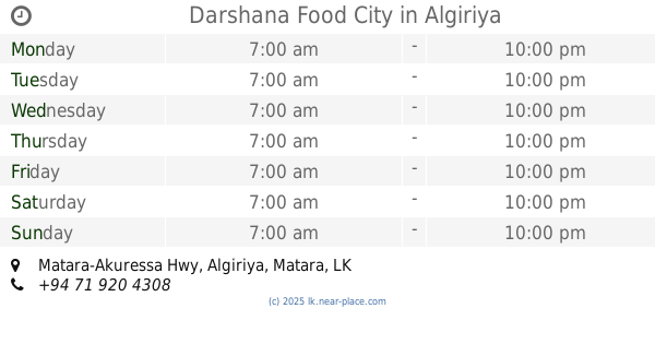
13.523 km
Darshana Food City
Matara-Akuressa Hwy, Algiriya
Gas station
read more
13.536 km
Darshana Gas Station
A24, Algiriya
Gas station
read more
13.536 km
Darshana Gas Station
Matara-Akuressa Hwy, Algiriya
Gas station
read more
14.295 km
Samupakara Filling Station
Matara - Hakmana Road, Kamburupitiya
Gas station
read more
14.508 km
Kandambi Fuel Station
Kamburupitiya
Gas station
read more
17.794 km
අළුත්ගංගොඩ හාර්ඩ්වෙයාර්
Diwalagoda - Kananke Road
Gas station
read more
18.393 km
Lanka Filling Station
B55, Hakmana
Gas station
read more
📑
all categories
Accounting
Administrative area level 1
Administrative area level 2
Airport
Amusement park
Aquarium
Art gallery
Atm
Bakery
Bank
Bar
Beauty salon
Bicycle store
Book store
Bowling alley
Bus station
Cafe
Campground
Car dealer
Car rental
Car repair
Car wash
Casino
Cemetery
Church
City hall
Clothing store
Colloquial area
Convenience store
Country
Courthouse
Dentist
Department store
Doctor
Electrician
Electronics store
Embassy
Finance
Fire station
Florist
Food
Funeral home
Furniture store
Gas station
General contractor
Grocery or supermarket
Gym
Hair care
Hardware store
Health
Hindu Temple
Home goods store
Hospital
Insurance agency
Intersection
Jewelry store
Laundry
Lawyer
Library
Light rail station
Liquor store
Local government office
Locality
Locksmith
Lodging
Meal delivery
Meal takeaway
Mosque
Movie rental
Movie theater
Moving company
Museum
Natural feature
Neighborhood
Night club
Painter
Park
Parking
Pet store
Pharmacy
Physiotherapist
Place of worship
Plumber
Point of interest
Police
Political
Post office
Premise
Real estate agency
Restaurant
Roofing contractor
Route
Rv park, camping
School
Shoe store
Shopping mall
Spa
Stadium
Storage
Store
Subpremise
Supermarket
Synagogue
Taxi stand
Train station
Transit station
Travel agency
University
Veterinary care
Zoo
administrative area level 3
sublocality level 1
sublocality level 2
↑