Gas station nearby Informax
Sri Lanka
Gas station nearby Informax
Informax
Sri Lanka
contacts phone
:
+94
Latitude:
6.9451218
, Longitude:
79.8849177
larger map & directions
read more
nearest Gas station
720 m
Laugfs Filling Station
Colombo 09
Gas station
read more
738 m
Laugfs Filling Station
Colombo
Gas station
read more
1.15 km
Lanka Filling Station
Colombo
Gas station
read more
1.207 km
Filling Station
Peliyagoda
Gas station
read more
1.207 km
S N Jayasinghe IOC Filling Station
Kandy Rd, Peliyagoda
Gas station
read more
1.228 km
Janaruwan Traders
Sri Bodhiraja Mawatha, Colombo
Gas station
read more
1.263 km
Petrol Pump
Colombo
Gas station
read more
1.276 km
Petrol Pump
Kotuwila, Colombo
Gas station
read more
1.296 km
Wellampitiya Filling Stattion
B435
Gas station
read more
1.331 km
Kumara Traders
Biyagama Road, Peliyagoda
Gas station
read more
1.34 km
Ceypetco Fuel Station
Peliyagoda
Gas station
read more
1.426 km
Sithum Suppliers
Sedawatta - Ambatale Road
Gas station
read more
1.428 km
Pumping Station
Grandpass
Gas station
read more
1.428 km
Pumping Station
Colombo 14
Gas station
read more
1.539 km
Fahim Gas Center
Maligawatta Lane, Colombo
Gas station
read more
1.648 km
Filling Station
70 Mahakumarage Road, Colombo
Gas station
read more
1.809 km
Litro Gas
Gas station
read more
1.809 km
Litro Gas
Sri Lanka
Gas station
read more
1.884 km
Anu Enterprises (HHH)
Maligawatte Road, Colombo
Gas station
read more
1.906 km
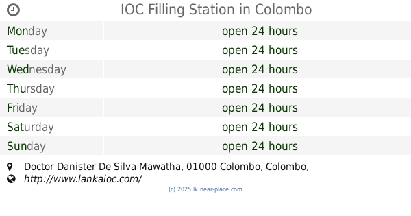
IOC Filling Station
Doctor Danister De Silva Mawatha, Colombo
Gas station
read more
2.022 km
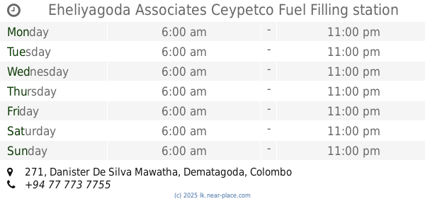
Eheliyagoda Associates Ceypetco Fuel Filling station
271, Danister De Silva Mawatha, Dematagoda, Colombo
Gas station
read more
2.035 km
IOC Leanfirm pvt ltd
107 negombo road peliyagoda., Negombo-Colombo Main Road
Gas station
read more
2.035 km
IOC Petrol Shed
Wattala
Gas station
read more
2.161 km
Dilnaz Gas Center
J A Milton Perera Mawatha, Colombo
Gas station
read more
2.254 km
IOC Filling Station
Pradeepa Rd, Colombo
Gas station
read more
📑
all categories
Accounting
Administrative area level 1
Administrative area level 2
Airport
Amusement park
Aquarium
Art gallery
Atm
Bakery
Bank
Bar
Beauty salon
Bicycle store
Book store
Bowling alley
Bus station
Cafe
Campground
Car dealer
Car rental
Car repair
Car wash
Casino
Cemetery
Church
City hall
Clothing store
Colloquial area
Convenience store
Country
Courthouse
Dentist
Department store
Doctor
Electrician
Electronics store
Embassy
Finance
Fire station
Florist
Food
Funeral home
Furniture store
Gas station
General contractor
Grocery or supermarket
Gym
Hair care
Hardware store
Health
Hindu Temple
Home goods store
Hospital
Insurance agency
Intersection
Jewelry store
Laundry
Lawyer
Library
Light rail station
Liquor store
Local government office
Locality
Locksmith
Lodging
Meal delivery
Meal takeaway
Mosque
Movie rental
Movie theater
Moving company
Museum
Natural feature
Neighborhood
Night club
Painter
Park
Parking
Pet store
Pharmacy
Physiotherapist
Place of worship
Plumber
Point of interest
Police
Political
Post office
Premise
Real estate agency
Restaurant
Roofing contractor
Route
Rv park, camping
School
Shoe store
Shopping mall
Spa
Stadium
Storage
Store
Subpremise
Supermarket
Synagogue
Taxi stand
Train station
Transit station
Travel agency
University
Veterinary care
Zoo
administrative area level 3
sublocality level 1
sublocality level 2
↑