Gym nearby Fitness Kingdom ragama
Sri Lanka
Gym nearby Fitness Kingdom ragama
Fitness Kingdom ragama
Katage Watta Road, Ragama, Gampaha, LK Sri Lanka
contacts phone
:
+94 112 952 884
Latitude:
7.0299221
, Longitude:
79.9227085
larger map & directions
read more
nearest Gym
256 m
R.k Fitness center
Ragama
Gym
read more
392 m
Lakpriya Edirisinghe Badminton Court
Araliya Uyana, Ragama
Gym
read more
415 m
My Gym Ragama/Thrilow
69/F sirirwardana Road, Ragama
Gym
read more
417 m
My Gym Ragama
Sri Lanka
Gym
read more
680 m
Kodd Fitness Center and Gym Ragama
Ragama, Sri Lanka No. 85A, Mahabage Road, Ragama, Ragama
Gym
read more
722 m
Faculty of Medicine Ragama Sports Complex
Annasihena Road, Ragama
Gym
read more
2.232 km
Renil Fernando Matrial Art Dojo
Linton Road, Ragama
Gym
read more
2.388 km
Saku Fitness
Ragama Batuwatta Road, Narangoda Paluwa
Gym
read more
2.672 km
SM Fitness
550 Kandana - Ganemulla Road, Ja-Ela
Gym
read more
2.704 km
Power Zone Gym
Alehiwatte Road, Welisara
Gym
read more
2.731 km
Geshela Spa
4/3.no 48, Negombo Rd, Kandana
Gym
read more
2.764 km
Shakthi Gym
Nagoda Kandana, Ragama
Gym
read more
3.23 km
Power World Gym
Chilaw - Colombo Main Road, Magammana
Gym
read more
3.237 km
FOCUS FITNESS ZUMBA STUDIO
Chilaw - Colombo Main Road, Magammana
Gym
read more
3.264 km
Tharanga Beauty Salon
Station Road, Kandana
Gym
read more
3.3 km
Shakthi Gym
399 Parakrama Road, Wattala
Gym
read more
3.709 km
Revolution Fitness
Kandana
Gym
read more
3.808 km
Power Gym
Kandana
Gym
read more
3.836 km
Super Sports Gym
Kandana
Gym
read more
3.977 km
Ruzan
Wattala
Gym
read more
4.076 km
Sendra Sports Center
Sri Lanka
Gym
read more
4.086 km
Zumba Studio.
178 D rilaulla juntion,negombo road,kandana
Gym
read more
4.087 km
Workout Fitness Center
68 Negombo-Colombo Main Road, Ja-Ela
Gym
read more
4.088 km
Danzo Fitness
Kandana
Gym
read more
6.121 km
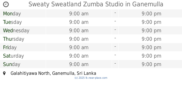
Sweaty Sweatland Zumba Studio
Galahitiyawa North, Ganemulla
Gym
read more
📑
all categories
Accounting
Administrative area level 1
Administrative area level 2
Airport
Amusement park
Aquarium
Art gallery
Atm
Bakery
Bank
Bar
Beauty salon
Bicycle store
Book store
Bowling alley
Bus station
Cafe
Campground
Car dealer
Car rental
Car repair
Car wash
Casino
Cemetery
Church
City hall
Clothing store
Colloquial area
Convenience store
Country
Courthouse
Dentist
Department store
Doctor
Electrician
Electronics store
Embassy
Finance
Fire station
Florist
Food
Funeral home
Furniture store
Gas station
General contractor
Grocery or supermarket
Gym
Hair care
Hardware store
Health
Hindu Temple
Home goods store
Hospital
Insurance agency
Intersection
Jewelry store
Laundry
Lawyer
Library
Light rail station
Liquor store
Local government office
Locality
Locksmith
Lodging
Meal delivery
Meal takeaway
Mosque
Movie rental
Movie theater
Moving company
Museum
Natural feature
Neighborhood
Night club
Painter
Park
Parking
Pet store
Pharmacy
Physiotherapist
Place of worship
Plumber
Point of interest
Police
Political
Post office
Premise
Real estate agency
Restaurant
Roofing contractor
Route
Rv park, camping
School
Shoe store
Shopping mall
Spa
Stadium
Storage
Store
Subpremise
Supermarket
Synagogue
Taxi stand
Train station
Transit station
Travel agency
University
Veterinary care
Zoo
administrative area level 3
sublocality level 1
sublocality level 2
↑