Gym nearby Gamunu Sport Club Ground
Sri Lanka
Gym nearby Gamunu Sport Club Ground
Gamunu Sport Club Ground
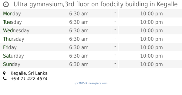
Kegalle, Sri Lanka
contacts phone
:
+94
Latitude:
7.1196229
, Longitude:
80.2317203
larger map & directions
read more
nearest Gym
4.362 km
Miton Furniture.
Kegalle
Gym
read more
10.136 km
Damro public service Academy Urapola
Gampaha
Gym
read more
11.205 km
Karawanelle City
Kegalle
Gym
read more
12.36 km
fitness kingdom yatiyantota
Yatiyantota-Punugala-Meenagala Road, Yatiyanthota
Gym
read more
13.015 km
Life Light Fitness - Pasyala
Pasyala
Gym
read more
13.281 km
Jayalanka Fitness Center
Ganewatta Road, Makkanigoda
Gym
read more
13.354 km
M.M.A club
Kurawalana
Gym
read more
13.531 km
Sha Fitness Center
Nittambuwa
Gym
read more
13.629 km
Metalica Gym
AB29, Gampaha
Gym
read more
13.959 km
Eksath Sport Club
Eksath sport club kirindewela
Gym
read more
14.247 km
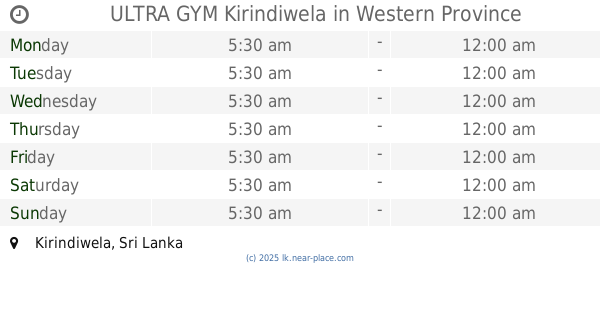
ULTRA GYM Kirindiwela
Kirindiwela
Gym
read more
14.31 km
Shakthi Fitness Centre
Ogodapola
Gym
read more
14.32 km
District Level Sports Complex
Wathupitiwala
Gym
read more
14.321 km
Fitness Gym
Opathella Road
Gym
read more
14.328 km
MGM Gym
Opathella Road
Gym
read more
14.514 km
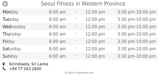
Seoul Fitness
Kirindiwela
Gym
read more
14.774 km
සල්ගාදු ප්රජාශාලාව - නව පොලටගම
104 B482, Malalpola
Gym
read more
15.206 km
Bushido Acamemy
A/B-7/17 Nittambuwa - Ruwanwella Road, Nittambuwa
Gym
read more
17.561 km
Regency Fitness Center center (gym)
Hettimulla
Gym
read more
18.076 km
Pathum Fitness Center
Mirigama
Gym
read more
19.053 km
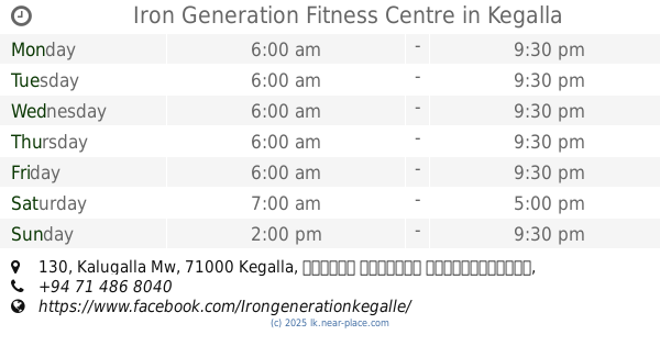
Iron Generation Fitness Centre
130 Kalugalla Mw, Kegalla
Gym
read more
19.189 km
Our JYM
Kegalle
Gym
read more
19.397 km
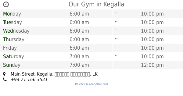
Our Gym
119/3, Main Street
Gym
read more
19.748 km
TITAN Fitness Center
TITAN Fitness Center, Colombo Road, Kegalle
Gym
read more
19.863 km
Ultra gymnasium,3rd floor on foodcity building
Kegalle
Gym
read more
📑
all categories
Accounting
Administrative area level 1
Administrative area level 2
Airport
Amusement park
Aquarium
Art gallery
Atm
Bakery
Bank
Bar
Beauty salon
Bicycle store
Book store
Bowling alley
Bus station
Cafe
Campground
Car dealer
Car rental
Car repair
Car wash
Casino
Cemetery
Church
City hall
Clothing store
Colloquial area
Convenience store
Country
Courthouse
Dentist
Department store
Doctor
Electrician
Electronics store
Embassy
Finance
Fire station
Florist
Food
Funeral home
Furniture store
Gas station
General contractor
Grocery or supermarket
Gym
Hair care
Hardware store
Health
Hindu Temple
Home goods store
Hospital
Insurance agency
Intersection
Jewelry store
Laundry
Lawyer
Library
Light rail station
Liquor store
Local government office
Locality
Locksmith
Lodging
Meal delivery
Meal takeaway
Mosque
Movie rental
Movie theater
Moving company
Museum
Natural feature
Neighborhood
Night club
Painter
Park
Parking
Pet store
Pharmacy
Physiotherapist
Place of worship
Plumber
Point of interest
Police
Political
Post office
Premise
Real estate agency
Restaurant
Roofing contractor
Route
Rv park, camping
School
Shoe store
Shopping mall
Spa
Stadium
Storage
Store
Subpremise
Supermarket
Synagogue
Taxi stand
Train station
Transit station
Travel agency
University
Veterinary care
Zoo
administrative area level 3
sublocality level 1
sublocality level 2
↑