Gym nearby Sushila Fitness Kingdom
Sri Lanka
Gym nearby Sushila Fitness Kingdom
Sushila Fitness Kingdom
Panadura, Sri Lanka
contacts phone
:
+94
Latitude:
6.7109308
, Longitude:
79.9071502
larger map & directions
read more
nearest Gym
481 m
The Gold Gym
385/2/1 Galle Road, Panadura
Gym
read more
978 m
Power World Gym
Colombo - Galle Main Road, Panadura
Gym
read more
978 m
Power World Panadura
Power World, panadura, Galle Road, Panadura
Gym
read more
1.001 km
Image Gym
322 Galle Road, Panadura
Gym
read more
1.034 km
Indika Fitness Center
681 Galle Road, Panadura
Gym
read more
1.142 km
The Gym Health & Fitness Center
Galle Road, Panadura
Gym
read more
1.193 km
UC swimming pool
Pattiya North, Panadura
Gym
read more
2.756 km
Naturub Fitness Center
Diyasegama Model Village Road, Panadura
Gym
read more
3.255 km
Fitness Land Health Care
Pinwatta West, Panadura
Gym
read more
3.944 km
mukshid
Jaya Mawatha, Panadura
Gym
read more
4.411 km
Shashi Indunil
180/1 Diganathuduwa Road, Panadura
Gym
read more
4.644 km
Power Fitness Center
Panadura
Gym
read more
6.406 km
Life Fitnes
Horana Road, Panadura
Gym
read more
8.85 km
Master Fitness Gym
6th Lane, Moratuwa
Gym
read more
8.988 km
Alpha Fitness
Colombo Road, Moratuwa
Gym
read more
9.259 km
Healthy Fit Fitness Center
Ratnapura - Horana - Panadura Highway, Bandaragama
Gym
read more
9.587 km
PAIN FREE FITNESS ARENA
Rawathawatta East, Moratuwa
Gym
read more
12.052 km
KDU Gym
Kandawala Road, Dehiwala-Mount Lavinia
Gym
read more
13.805 km
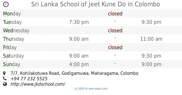
Sri Lanka School of Jeet Kune Do
7/7, Kohilakotuwa Road, Godigamuwa, Maharagama, Colombo
Gym
read more
14.581 km
Bellanwilla Walking Track
Boralesgamuwa West A, Boralesgamuwa
Gym
read more
14.672 km
Sanasa Gym
Godigamuwa South, B
Gym
read more
15.02 km
Car Park 2 Weras Jogging Path
211/5/I, 211/5/I Manis Dias Mawatha, Boralesgamuwa
Gym
read more
15.812 km
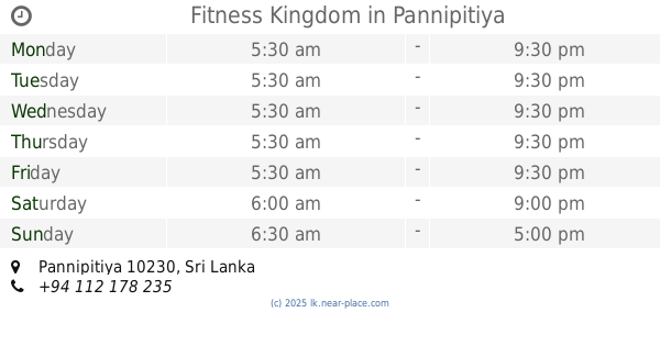
Fitness Kingdom
Pannipitiya
Gym
read more
15.87 km
Power World Fitness Center
Pannipitiya
Gym
read more
19.096 km
Vevo Fitness
Pitipana Junction, Homagama
Gym
read more
📑
all categories
Accounting
Administrative area level 1
Administrative area level 2
Airport
Amusement park
Aquarium
Art gallery
Atm
Bakery
Bank
Bar
Beauty salon
Bicycle store
Book store
Bowling alley
Bus station
Cafe
Campground
Car dealer
Car rental
Car repair
Car wash
Casino
Cemetery
Church
City hall
Clothing store
Colloquial area
Convenience store
Country
Courthouse
Dentist
Department store
Doctor
Electrician
Electronics store
Embassy
Finance
Fire station
Florist
Food
Funeral home
Furniture store
Gas station
General contractor
Grocery or supermarket
Gym
Hair care
Hardware store
Health
Hindu Temple
Home goods store
Hospital
Insurance agency
Intersection
Jewelry store
Laundry
Lawyer
Library
Light rail station
Liquor store
Local government office
Locality
Locksmith
Lodging
Meal delivery
Meal takeaway
Mosque
Movie rental
Movie theater
Moving company
Museum
Natural feature
Neighborhood
Night club
Painter
Park
Parking
Pet store
Pharmacy
Physiotherapist
Place of worship
Plumber
Point of interest
Police
Political
Post office
Premise
Real estate agency
Restaurant
Roofing contractor
Route
Rv park, camping
School
Shoe store
Shopping mall
Spa
Stadium
Storage
Store
Subpremise
Supermarket
Synagogue
Taxi stand
Train station
Transit station
Travel agency
University
Veterinary care
Zoo
administrative area level 3
sublocality level 1
sublocality level 2
↑