Health nearby Kegalu Optical
Sri Lanka
Health nearby Kegalu Optical
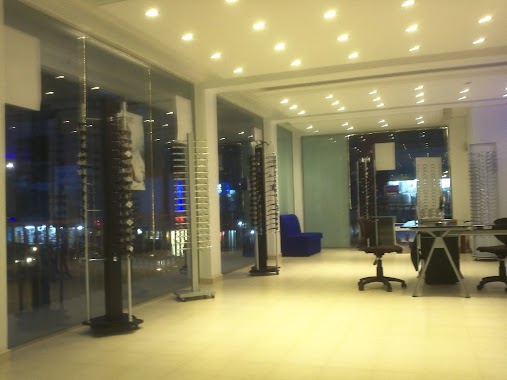
Kegalu Optical
Main Street, Kegalla, கேகாலை மாவட்டம், LK Sri Lanka
contacts phone
:
+94 352 222 140
Latitude:
7.2535613
, Longitude:
80.3482274
larger map & directions
read more
nearest Health
71 m
Asiri Laboratory Collection Centre
A1, Kegalle
Health
read more
71 m
Asiri Laboratory Collection Centre
A1, Kegalla
Health
read more
593 m
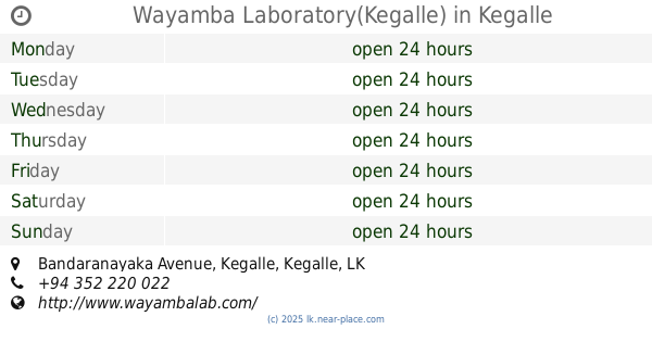
Wayamba Laboratory(Kegalle)
Bandaranayaka Avenue, Kegalle
Health
read more
661 m
Thapowanaya
Health
read more
846 m
Arogya X-ray
Kegalle
Health
read more
863 m
Harshani Spectacles
Kegalle
Health
read more
1.195 km
Chamee Pharmaceuticals ( Pvt ) Ltd
Kegalle
Health
read more
1.776 km
Kopiwaththa dispensary
A1, Ranwala Junction
Health
read more
1.883 km
Dr. W.P.W. Peiris Medical Cenre & Pharmacy
Kegalle
Health
read more
2.565 km
Dr. Manamper Medical Centre
Habudugala
Health
read more
4.622 km
kegalu medi lab
Galigamuwa
Health
read more
4.862 km
Medical Clinic - Dr. Ilangakoon
Hettimulla
Health
read more
5.373 km
Bandara Clinic
Hettimulla
Health
read more
8.961 km
A. A. Sumathipala Herbal Doctor
Pitagaldeniya
Health
read more
10.09 km
Pattagama Ayurweda Weda Medura
Aranayaka-Udagama Road
Health
read more
10.823 km
Kiyo me Pharmacy
Rambukkana-Mawanella Road, Mawanella
Health
read more
10.848 km
Dr. Kamal Dharmawanse's Medical Centre
Mawanella
Health
read more
10.852 km
United Pharmacy
No 183 Rambukkana-Mawanella Road, Mawanella
Health
read more
10.915 km
Daswatta Healthcare Centre
Daswatta Hettimulla-Diwala-Ussapitiya Road, Ussapitiya
Health
read more
10.936 km
Biochem Laboratories
3/4 New Colombo Road, Mawanella By Pass Road, Mawanella
Health
read more
11.15 km
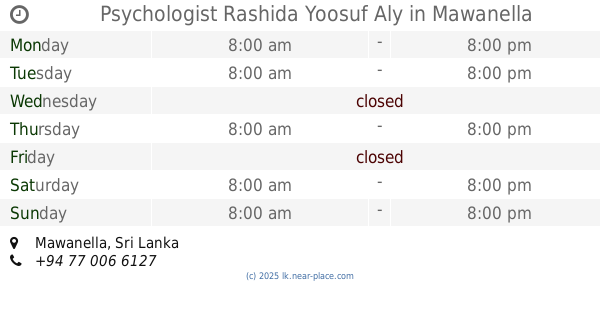
Psychologist Rashida Yoosuf Aly
Mawanella
Health
read more
11.432 km
Macro Pharmacy
Mawanella
Health
read more
14.535 km
MOH Ofiice Alawwa
B9
Health
read more
14.652 km
Kuwait Clinic
Nangalla
Health
read more
17.905 km
Galapitamada PMCU
Kegalle
Health
read more
📑
all categories
Accounting
Administrative area level 1
Administrative area level 2
Airport
Amusement park
Aquarium
Art gallery
Atm
Bakery
Bank
Bar
Beauty salon
Bicycle store
Book store
Bowling alley
Bus station
Cafe
Campground
Car dealer
Car rental
Car repair
Car wash
Casino
Cemetery
Church
City hall
Clothing store
Colloquial area
Convenience store
Country
Courthouse
Dentist
Department store
Doctor
Electrician
Electronics store
Embassy
Finance
Fire station
Florist
Food
Funeral home
Furniture store
Gas station
General contractor
Grocery or supermarket
Gym
Hair care
Hardware store
Health
Hindu Temple
Home goods store
Hospital
Insurance agency
Intersection
Jewelry store
Laundry
Lawyer
Library
Light rail station
Liquor store
Local government office
Locality
Locksmith
Lodging
Meal delivery
Meal takeaway
Mosque
Movie rental
Movie theater
Moving company
Museum
Natural feature
Neighborhood
Night club
Painter
Park
Parking
Pet store
Pharmacy
Physiotherapist
Place of worship
Plumber
Point of interest
Police
Political
Post office
Premise
Real estate agency
Restaurant
Roofing contractor
Route
Rv park, camping
School
Shoe store
Shopping mall
Spa
Stadium
Storage
Store
Subpremise
Supermarket
Synagogue
Taxi stand
Train station
Transit station
Travel agency
University
Veterinary care
Zoo
administrative area level 3
sublocality level 1
sublocality level 2
↑