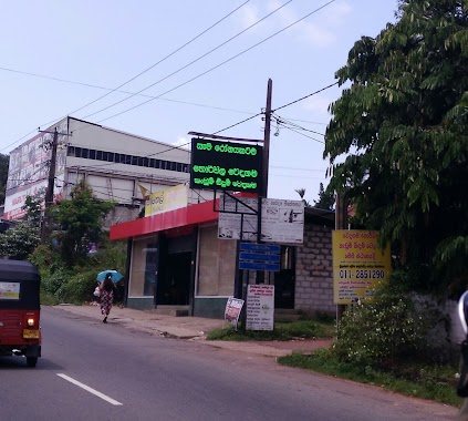
Health nearby Rajya Osusala
Sri Lanka
Health nearby Rajya Osusala
Rajya Osusala
Maharagama, Sri Lanka
contacts phone
:
+94
Latitude:
6.8478127
, Longitude:
79.9267005
larger map & directions
read more
nearest Health
91 m
Sameera Saranga Pharmacy
No 28, High Level Road, Maharagama
Health
read more
132 m
Sanoda Herbal Pvt Ltd
Town, Maharagama
Health
read more
319 m
Maharagama X Ray Center
Avissawella Road, Maharagama
Health
read more
423 m
giving sight giving life (A joint project of Karuna Trust & SLACO)
No: 114, Dehiwala Road, Maharagama
Health
read more
423 m
giving sight giving life (Project of Karuna trust)
No: 114, Dehiwala Road, Maharagama
Health
read more
436 m
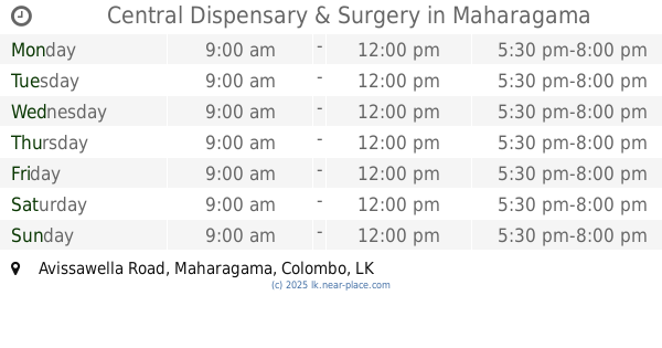
Central Dispensary & Surgery
No: 134/1, Avissawella Road, Maharagama
Health
read more
519 m
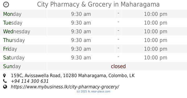
City Pharmacy & Grocery
159C Avissawella Road, Maharagama
Health
read more
530 m
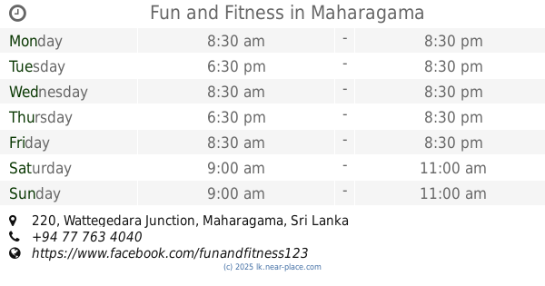
Fun and Fitness
220, Wattegedara Junction, Maharagama
Health
read more
538 m
Sri Nandana Hela Osu Medura
Health
read more
564 m
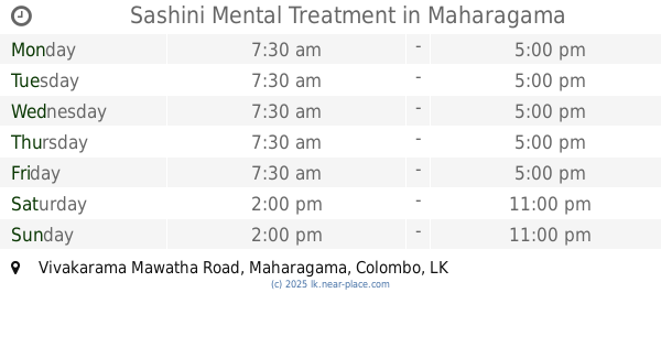
Sashini Mental Treatment
Vivakarama Mawatha Road, Maharagama
Health
read more
674 m
Doctors Clinic
178 Colombo - Batticaloa Highway, Maharagama
Health
read more
683 m
Elderly Care
#181 , Highlevel Road, Maharagama, Maharagama
Health
read more
708 m
Waththegedara Archi
Maharagama
Health
read more
736 m
Dispensary
5/8 B94, Maharagama
Health
read more
755 m
Dispensary And Surgery
Town, Maharagama
Health
read more
759 m
The Medical Centre
Health
read more
783 m
MAHARAGAMA EYE CLINIC
Health
read more
821 m
Jeewaka Pharmacy Maharagama
No:226 keels super, High Level Road, Maharagama
Health
read more
903 m
Nambapana Suwa Asapuwa
285 High Level Road, Navina
Health
read more
912 m
Nirapekshathwaye Maga
NO:97 Wattegedara Road, Maharagama
Health
read more
919 m
Homagama Vipassana Meditation Center
6°51'29. 79°59'52., 9 2nd Lane, මහරගම
Health
read more
1000 m
Jayani Medicare Pharmacy
Cancer Hospital Road, Maharagama
Health
read more
1.078 km
Wedagama-Horiwila Ayurwedic Treatment
Navinna, Maharagama
Health
read more
1.164 km
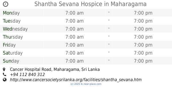
Shantha Sevana Hospice
Godigamuwa North, Cancer Hospital Road, Maharagama
Health
read more
1.223 km
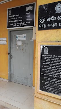
Maternity & Child Clinic- Pamunuwa
Maharagama
Health
read more
📑
all categories
Accounting
Administrative area level 1
Administrative area level 2
Airport
Amusement park
Aquarium
Art gallery
Atm
Bakery
Bank
Bar
Beauty salon
Bicycle store
Book store
Bowling alley
Bus station
Cafe
Campground
Car dealer
Car rental
Car repair
Car wash
Casino
Cemetery
Church
City hall
Clothing store
Colloquial area
Convenience store
Country
Courthouse
Dentist
Department store
Doctor
Electrician
Electronics store
Embassy
Finance
Fire station
Florist
Food
Funeral home
Furniture store
Gas station
General contractor
Grocery or supermarket
Gym
Hair care
Hardware store
Health
Hindu Temple
Home goods store
Hospital
Insurance agency
Intersection
Jewelry store
Laundry
Lawyer
Library
Light rail station
Liquor store
Local government office
Locality
Locksmith
Lodging
Meal delivery
Meal takeaway
Mosque
Movie rental
Movie theater
Moving company
Museum
Natural feature
Neighborhood
Night club
Painter
Park
Parking
Pet store
Pharmacy
Physiotherapist
Place of worship
Plumber
Point of interest
Police
Political
Post office
Premise
Real estate agency
Restaurant
Roofing contractor
Route
Rv park, camping
School
Shoe store
Shopping mall
Spa
Stadium
Storage
Store
Subpremise
Supermarket
Synagogue
Taxi stand
Train station
Transit station
Travel agency
University
Veterinary care
Zoo
administrative area level 3
sublocality level 1
sublocality level 2
↑