Hospital nearby Dental Sri Lanka
Sri Lanka
Hospital nearby Dental Sri Lanka
Dental Sri Lanka
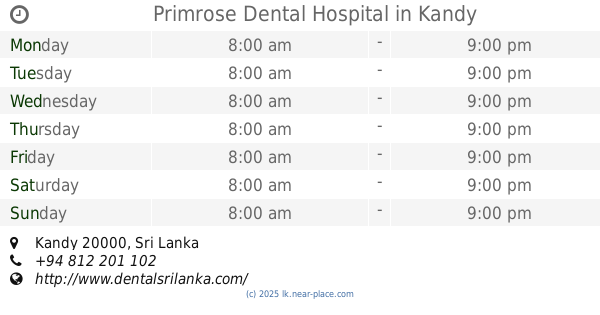
No 7, Primrose Road, Kandy., Kandy, Sri Lanka
contacts phone
:
+94 77 780 6084
website:
www.dentalsrilanka.com
Latitude:
7.280935
, Longitude:
80.618094
larger map & directions
read more
nearest Hospital
39 m
Primrose Dental Hospital
Kandy
Hospital
read more
57 m
Skin Center
Kandy
Hospital
read more
165 m
Daya Nivasa Home of Care for the Disabled
619 Peradeniya Road, Kandy
Hospital
read more
242 m
Respicare Dental Clinic
483/A William Gopallawa Mawatha, Kandy
Hospital
read more
274 m
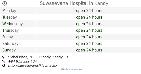
Suwasevana Hospital
No: 532, Siebel Place, Kandy
Hospital
read more
303 m
Suwasewana Hospital car park
883 A1, Kandy
Hospital
read more
318 m
Mobile Medicare Hospital
665A, Road, මහනුවර
Hospital
read more
359 m
Fertaid Baby Hospital
619 Peradeniya Road, Kandy
Hospital
read more
401 m
Suwasewana Hospital
627 Peradeniya Road, Kandy
Hospital
read more
842 m
New Medi Clinic
Kandy
Hospital
read more
858 m
Nuwara Ps Pharmacy Ltd
893 Peradeniya Road, Kandy
Hospital
read more
862 m
kuswala ayurvedaya
676 Kandy Hwy Kandy 20000, Colombo
Hospital
read more
949 m
Aloka Diagnostics
673 William Gopallawa Mawatha, Kandy
Hospital
read more
1.002 km
Asiri Hospital
Kandy
Hospital
read more
1.02 km
Asiri Hospital Complex
Kandy
Hospital
read more
1.026 km
Asiri Hospital - Kandy
Sirimawo, Peradeniya Road, Kandy
Hospital
read more
1.394 km
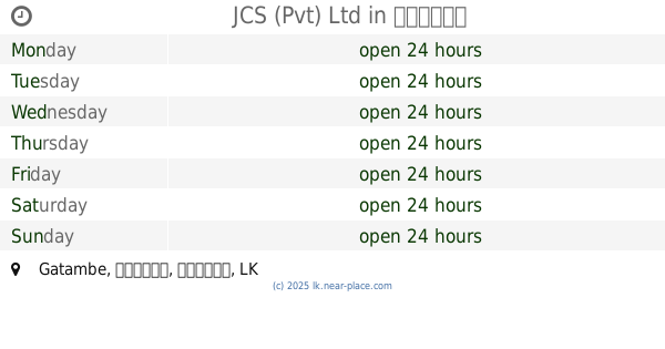
JCS (Pvt) Ltd
Gatambe, Kandy
Hospital
read more
1.437 km
Kandy Diabetes Center
267, පේරාදෙණිය පාර, මහනුවර
Hospital
read more
1.611 km
Ward 30, 31, 33, 35
Kandy
Hospital
read more
1.632 km
Cardiothoracic Unit
Kandy
Hospital
read more
1.635 km
Cardiology and Cardiothoract Unit
Kandy
Hospital
read more
1.689 km
ETU
Kandy
Hospital
read more
1.819 km
Gov.School of Nursing, Kandy
Kandy
Hospital
read more
2.07 km
ISIWARA Specialist Consultant Service
No 13, Peradeniya road,, Kandy
Hospital
read more
2.07 km
ISIWARA Specialist Consultant Service
13 Peradeniya Road, Kandy
Hospital
read more
📑
all categories
Accounting
Administrative area level 1
Administrative area level 2
Airport
Amusement park
Aquarium
Art gallery
Atm
Bakery
Bank
Bar
Beauty salon
Bicycle store
Book store
Bowling alley
Bus station
Cafe
Campground
Car dealer
Car rental
Car repair
Car wash
Casino
Cemetery
Church
City hall
Clothing store
Colloquial area
Convenience store
Country
Courthouse
Dentist
Department store
Doctor
Electrician
Electronics store
Embassy
Finance
Fire station
Florist
Food
Funeral home
Furniture store
Gas station
General contractor
Grocery or supermarket
Gym
Hair care
Hardware store
Health
Hindu Temple
Home goods store
Hospital
Insurance agency
Intersection
Jewelry store
Laundry
Lawyer
Library
Light rail station
Liquor store
Local government office
Locality
Locksmith
Lodging
Meal delivery
Meal takeaway
Mosque
Movie rental
Movie theater
Moving company
Museum
Natural feature
Neighborhood
Night club
Painter
Park
Parking
Pet store
Pharmacy
Physiotherapist
Place of worship
Plumber
Point of interest
Police
Political
Post office
Premise
Real estate agency
Restaurant
Roofing contractor
Route
Rv park, camping
School
Shoe store
Shopping mall
Spa
Stadium
Storage
Store
Subpremise
Supermarket
Synagogue
Taxi stand
Train station
Transit station
Travel agency
University
Veterinary care
Zoo
administrative area level 3
sublocality level 1
sublocality level 2
↑