Hospital nearby Private Hospital
Sri Lanka
Hospital nearby Private Hospital
Private Hospital
Trincomalee, Sri Lanka
contacts phone
:
+94
Latitude:
8.5874149
, Longitude:
81.2064515
larger map & directions
read more
nearest Hospital
19 m
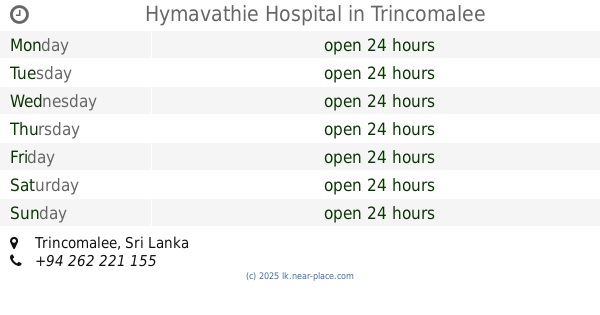
Hymavathie Hospital
Trincomalee
Hospital
read more
61 m
Lucky Parmacy
Trincomalee
Hospital
read more
314 m
Arogya Ayurveda Medical Centre
Trincomalee
Hospital
read more
989 m
Medical apayapura
2 A6, Trincomalee
Hospital
read more
1.266 km
government hospital
Trincomalee
Hospital
read more
1.268 km
Vihraj Clinic
2 Kandy Road, Trincomalee
Hospital
read more
1.268 km
Vihraj Clinic
2 A6, Trincomalee
Hospital
read more
1.522 km
Biomedical Division Trincomalee
Trincomalee
Hospital
read more
1.776 km
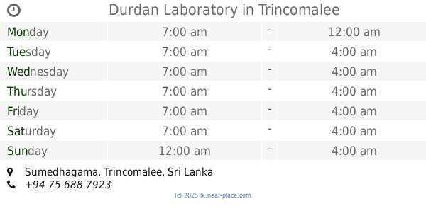
Durdan Laboratory
Trincomalee
Hospital
read more
1.8 km
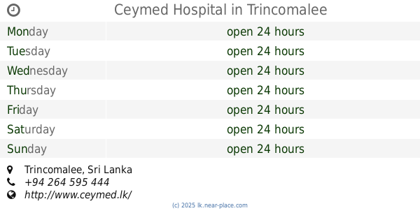
Ceymed Hospital
Trincomalee
Hospital
read more
1.805 km
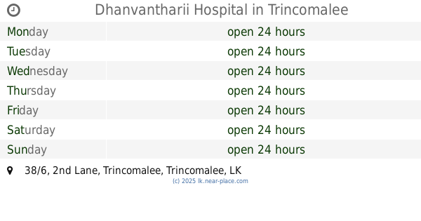
Dhanvantharii Hospital
38/6 2nd Lane, Trincomalee
Hospital
read more
1.83 km
Eden Medical Clinic
Trincomalee
Hospital
read more
1.975 km
Dhanvanthri Hospital
No 3 Kandy Road Trincomallee, Kandy Road, திருகோணமலை
Hospital
read more
1.984 km
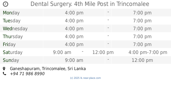
Dental Surgery. 4th Mile Post
Trincomalee
Hospital
read more
2.666 km
Smile Care Dental Clinic
Sea View Road, Trincomalee
Hospital
read more
2.837 km
New City Medi Cure Dr T Sureshkumar
Thillai Nagar, Trincomalee
Hospital
read more
2.851 km
Western medical service
North Coast Road, Trincomalee
Hospital
read more
3.227 km
Quick Medi Care DR Kuganendran
Trincomalee
Hospital
read more
3.367 km
Central hospital
Trincomalee
Hospital
read more
4.373 km
Durdans Laboratory
Trincomalee
Hospital
read more
4.409 km
Trincomalee General Hospital
Trincomalee
Hospital
read more
4.495 km
MHU General Hospital Trincomalee.
Hospital Lane, Trincomalee
Hospital
read more
4.495 km
District General Hospital Trincomalee
Hospital Lane, Trincomalee
Hospital
read more
11.368 km
Naduthteevu Hospital
Kakamunai
Hospital
read more
15.145 km
Sampur HOSPITAL
Trincomalee
Hospital
read more
📑
all categories
Accounting
Administrative area level 1
Administrative area level 2
Airport
Amusement park
Aquarium
Art gallery
Atm
Bakery
Bank
Bar
Beauty salon
Bicycle store
Book store
Bowling alley
Bus station
Cafe
Campground
Car dealer
Car rental
Car repair
Car wash
Casino
Cemetery
Church
City hall
Clothing store
Colloquial area
Convenience store
Country
Courthouse
Dentist
Department store
Doctor
Electrician
Electronics store
Embassy
Finance
Fire station
Florist
Food
Funeral home
Furniture store
Gas station
General contractor
Grocery or supermarket
Gym
Hair care
Hardware store
Health
Hindu Temple
Home goods store
Hospital
Insurance agency
Intersection
Jewelry store
Laundry
Lawyer
Library
Light rail station
Liquor store
Local government office
Locality
Locksmith
Lodging
Meal delivery
Meal takeaway
Mosque
Movie rental
Movie theater
Moving company
Museum
Natural feature
Neighborhood
Night club
Painter
Park
Parking
Pet store
Pharmacy
Physiotherapist
Place of worship
Plumber
Point of interest
Police
Political
Post office
Premise
Real estate agency
Restaurant
Roofing contractor
Route
Rv park, camping
School
Shoe store
Shopping mall
Spa
Stadium
Storage
Store
Subpremise
Supermarket
Synagogue
Taxi stand
Train station
Transit station
Travel agency
University
Veterinary care
Zoo
administrative area level 3
sublocality level 1
sublocality level 2
↑