Library nearby Public Library
Sri Lanka
Library nearby Public Library
Public Library
Nittambuwa, Sri Lanka
contacts phone
:
+94
Latitude:
7.1442327
, Longitude:
80.0940013
larger map & directions
read more
nearest Library
1.137 km
Bandaranayaka Memorial Library
Sri Lanka
Library
read more
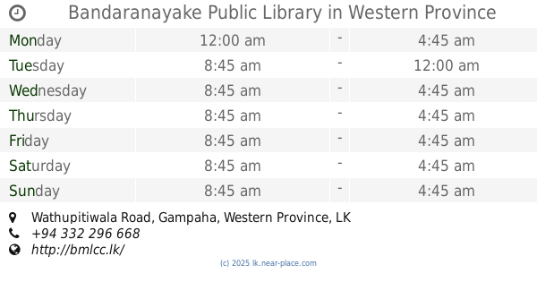
1.143 km
Bandaranayake Public Library
Wathupitiwala Road
Library
read more
3.921 km
Science Library
Veyangoda-Keenawala Road, Veyangoda
Library
read more
4.097 km
Public Library Veyangoda
Siriwardhana Road, Veyangoda
Library
read more
4.102 km
Main Town Library
Veyangoda
Library
read more
4.394 km
Ruggahawila Public Library
Ruggahawila-Kiththammahara Road
Library
read more
5.57 km
Badheebiyya Library
Kahatowita
Library
read more
6.015 km
Pallewela Library
Kaleliya - Medagampitiya Road
Library
read more
7.023 km
Public Library Bemmulla
Gampaha
Library
read more
8.072 km
Public Library Algama
Algama
Library
read more
8.081 km
ධර්මසිරි සේනානායක පුස්තකාලය
Algama
Library
read more
9.565 km
ධර්මසිරි සේනානායක පුස්තකාලය
Horagasmankada - Algama Road, Godawela
Library
read more
9.647 km
Public library
Yakkala
Library
read more
10.197 km
Malwathuhiripitiya Public Library
Malwathu Hiripitiya
Library
read more
10.285 km
Dewalapola Public Library
Katunayake-Veyangoda Road
Library
read more
11.824 km
Publick Library
Divulapitiya
Library
read more
12.065 km
Gampha Public Library
Gampaha
Library
read more
12.601 km
VILIMBULA PUBLIC LIBRARY
Vilimbula North
Library
read more
12.676 km
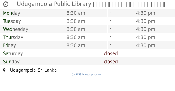
Udugampola Public Library උඩුගම්පොල මහජන පුස්තකාලය
Udugampola
Library
read more
13.264 km
Senarath Paranavithana National School Library
Udugampola
Library
read more
14.266 km
Warakapola Public Library
Warakapola By Pass Road, Warakapola
Library
read more
15.212 km
කණ්ඩලම පුස්තකාලය
Warakapola-Kandalama Road, Pirisyala
Library
read more
15.719 km
Ambepussa Community Library
Abepussa
Library
read more
16.557 km
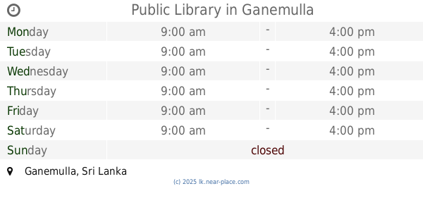
Public Library
Ganemulla
Library
read more
17.959 km
Weboda United Friend's Library
Webada Road
Library
read more
📑
all categories
Accounting
Administrative area level 1
Administrative area level 2
Airport
Amusement park
Aquarium
Art gallery
Atm
Bakery
Bank
Bar
Beauty salon
Bicycle store
Book store
Bowling alley
Bus station
Cafe
Campground
Car dealer
Car rental
Car repair
Car wash
Casino
Cemetery
Church
City hall
Clothing store
Colloquial area
Convenience store
Country
Courthouse
Dentist
Department store
Doctor
Electrician
Electronics store
Embassy
Finance
Fire station
Florist
Food
Funeral home
Furniture store
Gas station
General contractor
Grocery or supermarket
Gym
Hair care
Hardware store
Health
Hindu Temple
Home goods store
Hospital
Insurance agency
Intersection
Jewelry store
Laundry
Lawyer
Library
Light rail station
Liquor store
Local government office
Locality
Locksmith
Lodging
Meal delivery
Meal takeaway
Mosque
Movie rental
Movie theater
Moving company
Museum
Natural feature
Neighborhood
Night club
Painter
Park
Parking
Pet store
Pharmacy
Physiotherapist
Place of worship
Plumber
Point of interest
Police
Political
Post office
Premise
Real estate agency
Restaurant
Roofing contractor
Route
Rv park, camping
School
Shoe store
Shopping mall
Spa
Stadium
Storage
Store
Subpremise
Supermarket
Synagogue
Taxi stand
Train station
Transit station
Travel agency
University
Veterinary care
Zoo
administrative area level 3
sublocality level 1
sublocality level 2
↑