Library nearby Urban Council Library
Sri Lanka
Library nearby Urban Council Library
Urban Council Library
Station Road, Ja-Ela, Gampaha, LK Sri Lanka
contacts phone
:
+94
Latitude:
7.0778383
, Longitude:
79.8913497
larger map & directions
read more
nearest Library
2.307 km
Immcaulate Mother of Ludes Library
Ja-Ela
Library
read more
3.316 km
Kandana Public Library
Kandana Circular Road, Ja-Ela
Library
read more
4.656 km
Walpola Public Library
Batuwatta
Library
read more
4.787 km
Batuwatta Public Library
Walpola Bollata Road, Ja-Ela
Library
read more
6.34 km
Welisara Public Library - වැලිසර මහජන පුස්තකාලය
A3, Ragama
Library
read more
6.353 km
Mahabage Public Library
A3, රාගම
Library
read more
6.601 km
Narangodapaluwa Library
Gamunu Mawatha, Narangoda Paluwa
Library
read more
6.892 km
Junior Library - Galahitiyawa central college
Galahitiyawa North, Ganemulla
Library
read more
7.142 km
Raddolugama Public Library
Katunayake
Library
read more
7.977 km
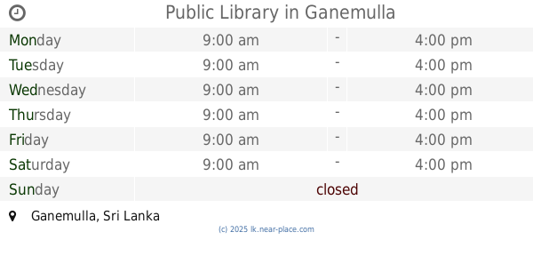
Public Library
Ganemulla
Library
read more
9.5 km
Pattaduwana Library
Uggalboda Road, Paththanduwana
Library
read more
9.836 km
Public Library
Wattala
Library
read more
10.579 km
YMBA Library
Kadawatha By Pass Road, Kadawatha
Library
read more
11.333 km
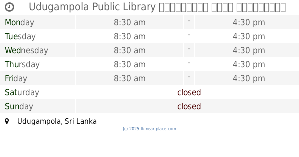
Udugampola Public Library උඩුගම්පොල මහජන පුස්තකාලය
Udugampola
Library
read more
11.559 km
Public Library - Wewalduwa
Sri Lanka
Library
read more
11.8 km
Gampha Public Library
Gampaha
Library
read more
11.92 km
Thalahena Public Library
Negombo
Library
read more
12.626 km
Dalugamgoda Public Library
328/E Old Kandy Road, Kelaniya
Library
read more
14.059 km
Public Library Mawaramandiya
Mawaramandiya
Library
read more
14.809 km
Public Library - Kotahena
Colombo
Library
read more
14.865 km
Public Library
Angurukaramulla
Library
read more
16.519 km
Public Library Thotillagahawatta
Negombo - Aluthepola Road, Aluthepola
Library
read more
16.822 km
Delgoda Library
Sri Lanka
Library
read more
18.429 km
BOI Library
Sri Lanka
Library
read more
19.446 km
Malwana Public Library
Sri Lanka
Library
read more
📑
all categories
Accounting
Administrative area level 1
Administrative area level 2
Airport
Amusement park
Aquarium
Art gallery
Atm
Bakery
Bank
Bar
Beauty salon
Bicycle store
Book store
Bowling alley
Bus station
Cafe
Campground
Car dealer
Car rental
Car repair
Car wash
Casino
Cemetery
Church
City hall
Clothing store
Colloquial area
Convenience store
Country
Courthouse
Dentist
Department store
Doctor
Electrician
Electronics store
Embassy
Finance
Fire station
Florist
Food
Funeral home
Furniture store
Gas station
General contractor
Grocery or supermarket
Gym
Hair care
Hardware store
Health
Hindu Temple
Home goods store
Hospital
Insurance agency
Intersection
Jewelry store
Laundry
Lawyer
Library
Light rail station
Liquor store
Local government office
Locality
Locksmith
Lodging
Meal delivery
Meal takeaway
Mosque
Movie rental
Movie theater
Moving company
Museum
Natural feature
Neighborhood
Night club
Painter
Park
Parking
Pet store
Pharmacy
Physiotherapist
Place of worship
Plumber
Point of interest
Police
Political
Post office
Premise
Real estate agency
Restaurant
Roofing contractor
Route
Rv park, camping
School
Shoe store
Shopping mall
Spa
Stadium
Storage
Store
Subpremise
Supermarket
Synagogue
Taxi stand
Train station
Transit station
Travel agency
University
Veterinary care
Zoo
administrative area level 3
sublocality level 1
sublocality level 2
↑