Lodging nearby Avendra Garden Hotel
Sri Lanka
Lodging nearby Avendra Garden Hotel
Avendra Garden Hotel
Monaragala, Sri Lanka
contacts phone
:
+94 552 055 800
website:
www.avendragarden.lk
Latitude:
6.8631343
, Longitude:
81.3513099
larger map & directions
read more
nearest Lodging
613 m
Mihiranga Guest Inn
Monaragala
Lodging
read more
709 m
Thotupola studio
65/1, No: 131, Wellawaya Road A4, Monaragala
Lodging
read more
723 m
Victory Inn
No. 65, Colombo - Batticaloa Highway, Monaragala
Lodging
read more
747 m
Hotel Sun Shine
Monaragala
Lodging
read more
749 m
Kanda Land Villa
Araliya Uyana Road, Monaragala
Lodging
read more
806 m
Rest House
Colombo - Batticaloa Highway, Monaragala
Lodging
read more
823 m
Kadupul Guest Inn
Monaragala
Lodging
read more
875 m
Ruby Hotel
Monaragala
Lodging
read more
887 m
Samara Guest Inn
Monaragala Road Wellawaya, Wellawaya
Lodging
read more
887 m
Green Paradise
Monaragala Road Wellawaya, Wellawaya
Lodging
read more
910 m
Kanvel Hotel Monaragala
No: 131, Wellawaya Road A4, Monaragala
Lodging
read more
923 m
Public Administration Circuit Bungalow - Moneragala
Monaragala
Lodging
read more
983 m
Friends World Guest House
Tissa Road, Monaragala
Lodging
read more
1.077 km
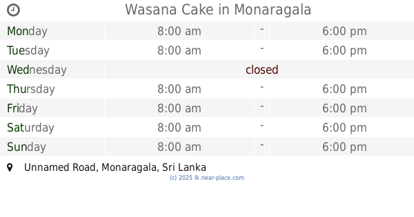
Wasana Cake
Unnamed Road, Monaragala
Lodging
read more
1.126 km
King top Hollyday inn
Monaragala
Lodging
read more
1.328 km
Hotel Elaine
27/67, Market Street
Lodging
read more
1.328 km
Hotel Elaine
27/67, Market Street, Monaragala
Lodging
read more
2.097 km
The Breeze Family Resort
Monaragala
Lodging
read more
2.413 km
Monaragala Resort
Monaragala
Lodging
read more
2.536 km
Circuit Bungalow - Department of Agriculture
Monaragala
Lodging
read more
2.766 km
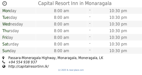
Capital Resort Inn
Passara-Moneragala Highway, Monaragala
Lodging
read more
2.782 km
Circuit Bungalow
Technical College, Sirigala, Monaragala.
Lodging
read more
3.022 km
G Lone Holiday Bungalow
Lodging
read more
5.186 km
Sandalanka Holiday Resort inn
Monaragala
Lodging
read more
5.775 km
LASINDU HOTEL
B56, Monaragala
Lodging
read more
📑
all categories
Accounting
Administrative area level 1
Administrative area level 2
Airport
Amusement park
Aquarium
Art gallery
Atm
Bakery
Bank
Bar
Beauty salon
Bicycle store
Book store
Bowling alley
Bus station
Cafe
Campground
Car dealer
Car rental
Car repair
Car wash
Casino
Cemetery
Church
City hall
Clothing store
Colloquial area
Convenience store
Country
Courthouse
Dentist
Department store
Doctor
Electrician
Electronics store
Embassy
Finance
Fire station
Florist
Food
Funeral home
Furniture store
Gas station
General contractor
Grocery or supermarket
Gym
Hair care
Hardware store
Health
Hindu Temple
Home goods store
Hospital
Insurance agency
Intersection
Jewelry store
Laundry
Lawyer
Library
Light rail station
Liquor store
Local government office
Locality
Locksmith
Lodging
Meal delivery
Meal takeaway
Mosque
Movie rental
Movie theater
Moving company
Museum
Natural feature
Neighborhood
Night club
Painter
Park
Parking
Pet store
Pharmacy
Physiotherapist
Place of worship
Plumber
Point of interest
Police
Political
Post office
Premise
Real estate agency
Restaurant
Roofing contractor
Route
Rv park, camping
School
Shoe store
Shopping mall
Spa
Stadium
Storage
Store
Subpremise
Supermarket
Synagogue
Taxi stand
Train station
Transit station
Travel agency
University
Veterinary care
Zoo
administrative area level 3
sublocality level 1
sublocality level 2
↑