Lodging nearby Dias guest house
Sri Lanka
Lodging nearby Dias guest house
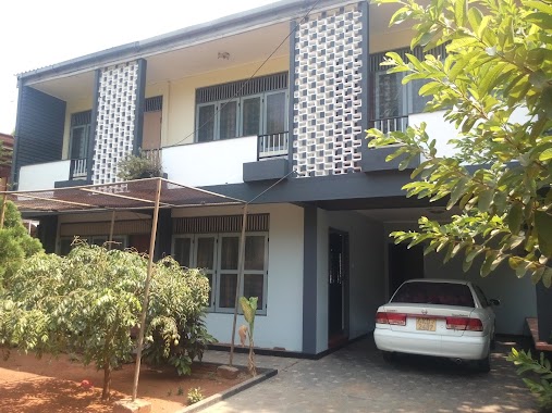
Dias guest house
Chundukuli, Jaffna, Sri Lanka
contacts phone
:
+94 77 615 6403
Latitude:
9.6560578
, Longitude:
80.0163228
larger map & directions
read more
nearest Lodging
338 m
Jaffna City Apartments
86 2nd Cross Street, Jaffna
Lodging
read more
494 m
Nilmini Lodge
Jaffna
Lodging
read more
501 m
Nilac LODGE Jaffna
Jaffna
Lodging
read more
502 m
NILMINI LODGE JAFFNA
Jaffna
Lodging
read more
548 m
Jo Enterprises Jaffna
No 23 Chapel Street, யாழ்ப்பாணம்
Lodging
read more
595 m
Woods INN
A9, Jaffna
Lodging
read more
595 m
Woods INN
Kandy - Jaffna Highway, Jaffna
Lodging
read more
648 m
Wood Rest Guesthouse
Jaffna
Lodging
read more
720 m
Kais City Guest House
No 47 Vembadi Road, Jaffna
Lodging
read more
775 m
Taprospa
Jaffna
Lodging
read more
863 m
St.Anne's Hotel & Resturant
6/2 St.Anne's Lane Pandiyanthalvu Chundikuli, யாழ்ப்பாணம்
Lodging
read more
887 m
Aster Guest House
Jaffna
Lodging
read more
899 m
Gangaa & Brothers Guest House
756, Hospital Road,, Jaffna
Lodging
read more
967 m
Jaffna Palace Hotel
Hospital Street, Jaffna
Lodging
read more
1.006 km
Nexus Luxury Private Homes,
20 First Lane, Jaffna
Lodging
read more
1.01 km
Kanagasundaram male hostel,Medical faculty,UOJ
Jaffna
Lodging
read more
1.022 km
Yaarl Holiday Inn
19 Kovil Road, Jaffna
Lodging
read more
1.025 km
Naga wiharaya pilgrims rest
Jaffna
Lodging
read more
1.025 km
Jetwing Jaffna
37, Mahatma Gandhi Road, Jaffna
Lodging
read more
1.034 km
Medical Hostel, UOJ
Jaffna
Lodging
read more
1.048 km
Northgate By Jetwing
Jaffna
Lodging
read more
1.07 km
Valampuri Hotel
148/10 Railway Station Rd, Jaffna
Lodging
read more
1.099 km
Green Grass Hotel & Restaurant
33 Asservatham Lane, Jaffna
Lodging
read more
1.129 km
Hotel Clock Tower
No.45, Muneeswaran Road, Jaffna
Lodging
read more
1.145 km
US Hotels (Pvt) Ltd
No. 855, Hospital Street, யாழ்ப்பாணம்
Lodging
read more
📑
all categories
Accounting
Administrative area level 1
Administrative area level 2
Airport
Amusement park
Aquarium
Art gallery
Atm
Bakery
Bank
Bar
Beauty salon
Bicycle store
Book store
Bowling alley
Bus station
Cafe
Campground
Car dealer
Car rental
Car repair
Car wash
Casino
Cemetery
Church
City hall
Clothing store
Colloquial area
Convenience store
Country
Courthouse
Dentist
Department store
Doctor
Electrician
Electronics store
Embassy
Finance
Fire station
Florist
Food
Funeral home
Furniture store
Gas station
General contractor
Grocery or supermarket
Gym
Hair care
Hardware store
Health
Hindu Temple
Home goods store
Hospital
Insurance agency
Intersection
Jewelry store
Laundry
Lawyer
Library
Light rail station
Liquor store
Local government office
Locality
Locksmith
Lodging
Meal delivery
Meal takeaway
Mosque
Movie rental
Movie theater
Moving company
Museum
Natural feature
Neighborhood
Night club
Painter
Park
Parking
Pet store
Pharmacy
Physiotherapist
Place of worship
Plumber
Point of interest
Police
Political
Post office
Premise
Real estate agency
Restaurant
Roofing contractor
Route
Rv park, camping
School
Shoe store
Shopping mall
Spa
Stadium
Storage
Store
Subpremise
Supermarket
Synagogue
Taxi stand
Train station
Transit station
Travel agency
University
Veterinary care
Zoo
administrative area level 3
sublocality level 1
sublocality level 2
↑