Lodging nearby Hotel Sudukekulu
Sri Lanka
Lodging nearby Hotel Sudukekulu
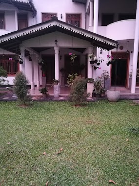
Hotel Sudukekulu
Soratha Mawatha, Gangodavila, Nugegoda, Sri Lanka
contacts phone
:
+94
Latitude:
6.9664322
, Longitude:
80.0974837
larger map & directions
read more
nearest Lodging
2.311 km
Hotel Pugoda Village
Pugoda-Mandawala Road
Lodging
read more
2.624 km
Muslim Hotel
Sri Lanka
Lodging
read more
2.624 km
Muslim Hotel
Lodging
read more
2.769 km
The Chalet
Sri Lanka
Lodging
read more
2.85 km
TIP TOP papadam company (pvt) LTD
Pugoda-Kosgama Road, Pugoda
Lodging
read more
3.959 km
Diyakadaima
70/A, Kandegedara Road, Weliwatta, Dompe, Dompe
Lodging
read more
3.974 km
Uyana Reception hall
Thiththapaththara
Lodging
read more
4.174 km
Palm Villa
Delgoda - Kirindiwela Road, Palahala
Lodging
read more
4.247 km
Kanro Holiday Resort
#117,, #117, Kirindiwela Road Thiththapaththara Hanwella - Kirindiwela - Urapola Road
Lodging
read more
4.586 km
Udayasiri Hotel
Sri Lanka
Lodging
read more
4.586 km
Grand Divine Hotel & Banquets
awissawella road, Kosgama
Lodging
read more
4.911 km
Minsara gest House
Gira, Imbula
Lodging
read more
4.969 km
Pawani Hotel
Sri Lanka
Lodging
read more
5.017 km
Aruna Hotel
Sri Lanka
Lodging
read more
5.017 km
Aruna Hotel
Lodging
read more
5.141 km
Lavenro Garden Hotel
Kosgama
Lodging
read more
5.165 km
Kumbuk Villa
NO: 177 Kaluaggala, Hanwella, Avissawella
Lodging
read more
5.296 km
Balasuriya Hotel
Sri Lanka
Lodging
read more
5.373 km
Grand Divine Hotel
119-3-B Pahala, Kosgama
Lodging
read more
5.436 km
Dompe Walauwa
No: 308, Mapitigama road,, Dompe
Lodging
read more
5.446 km
Suhada Hotel
Boralugoda-Mawalgama
Lodging
read more
9.688 km
Samagi Hotel
585,Uswatta Building, 531/5, Malwana Road
Lodging
read more
14.007 km
Sandasiri Hotel
Padukka
Lodging
read more
15.104 km
JSS Hostels
161/6/8, Malabe
Lodging
read more
18.945 km
Ranketha Hotel
Colombo - Batticaloa Highway, Pannipitiya
Lodging
read more
📑
all categories
Accounting
Administrative area level 1
Administrative area level 2
Airport
Amusement park
Aquarium
Art gallery
Atm
Bakery
Bank
Bar
Beauty salon
Bicycle store
Book store
Bowling alley
Bus station
Cafe
Campground
Car dealer
Car rental
Car repair
Car wash
Casino
Cemetery
Church
City hall
Clothing store
Colloquial area
Convenience store
Country
Courthouse
Dentist
Department store
Doctor
Electrician
Electronics store
Embassy
Finance
Fire station
Florist
Food
Funeral home
Furniture store
Gas station
General contractor
Grocery or supermarket
Gym
Hair care
Hardware store
Health
Hindu Temple
Home goods store
Hospital
Insurance agency
Intersection
Jewelry store
Laundry
Lawyer
Library
Light rail station
Liquor store
Local government office
Locality
Locksmith
Lodging
Meal delivery
Meal takeaway
Mosque
Movie rental
Movie theater
Moving company
Museum
Natural feature
Neighborhood
Night club
Painter
Park
Parking
Pet store
Pharmacy
Physiotherapist
Place of worship
Plumber
Point of interest
Police
Political
Post office
Premise
Real estate agency
Restaurant
Roofing contractor
Route
Rv park, camping
School
Shoe store
Shopping mall
Spa
Stadium
Storage
Store
Subpremise
Supermarket
Synagogue
Taxi stand
Train station
Transit station
Travel agency
University
Veterinary care
Zoo
administrative area level 3
sublocality level 1
sublocality level 2
↑