Lodging nearby Kabilan foods
Sri Lanka
Lodging nearby Kabilan foods
Kabilan foods
256, Negombo Road, Wattala, Gampaha, LK Sri Lanka
contacts phone
:
+94
Latitude:
6.9828087
, Longitude:
79.888418
larger map & directions
read more
nearest Lodging
166 m
Samara Hotel
Wattala
Lodging
read more
480 m
2 Br Furnished Apartment
174 Alwis Town, Wattala
Lodging
read more
668 m
Christopher Perera
209, Averiwatta - Hunupitiya - Wattala Junk Road, Wattala
Lodging
read more
751 m
Wattala Homestay
12 Kuda Edanda Road, වත්තල
Lodging
read more
846 m
Airport Homestay
626, 32 කොළඹ - පුත්තලම පාර, நீர்கொழும்பு
Lodging
read more
846 m
Airport Homestay
626, 32 කොළඹ - පුත්තලම පාර, මීගමුව
Lodging
read more
924 m
Holiday Home
203 Weliamuna Road, Wattala
Lodging
read more
1.038 km
Sanford Hotel, Wattala
Wattala
Lodging
read more
1.327 km
Heavenly Heritage Hotel
665a, Station Road, Wattala
Lodging
read more
1.4 km
hotel parami
Hunupitiya Road, Wattala
Lodging
read more
1.558 km
Mattakkuliya Temple
10/52-1 sri kelanigaga mill, road, Colombo
Lodging
read more
1.571 km
Rismiya Fruit Shop
Mattakkuliya, Colombo
Lodging
read more
1.591 km
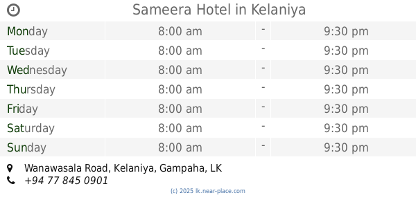
Sameera Hotel
no 88/2, Wanawasala Road, Kelaniya
Lodging
read more
1.611 km
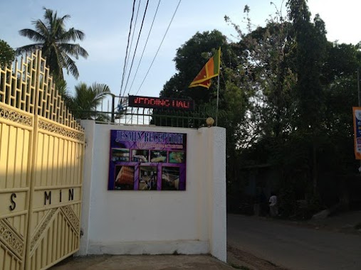
Jesmin Reception Hall
Dippitigoda Road, Kelaniya
Lodging
read more
1.907 km
Laksiri Hotel
Colombo
Lodging
read more
1.992 km
SS Hostel & Residencies
Palliyawatte Rd, Wattala
Lodging
read more
2.045 km
Raja Hotel
24 Balagala Road, Wattala
Lodging
read more
2.047 km
Siraj Hotel & Bakery
Wattala
Lodging
read more
2.179 km
Kelani Hotel
K J Peiris Road, Peliyagoda
Lodging
read more
2.327 km
Kajen Accommodation
451/7 Ferguson Road, Colombo
Lodging
read more
2.367 km
Feels Like Home
41, Joseph Dias Lane, Colombo 15, කොළඹ
Lodging
read more
2.435 km
Sarasa Hotel
Dalugama
Lodging
read more
2.446 km
Malsha Hotel
Sri Lanka
Lodging
read more
2.538 km
HNDE girls' hostel
Colombo
Lodging
read more
2.559 km
HNDE Boys' Hostel
Colombo
Lodging
read more
📑
all categories
Accounting
Administrative area level 1
Administrative area level 2
Airport
Amusement park
Aquarium
Art gallery
Atm
Bakery
Bank
Bar
Beauty salon
Bicycle store
Book store
Bowling alley
Bus station
Cafe
Campground
Car dealer
Car rental
Car repair
Car wash
Casino
Cemetery
Church
City hall
Clothing store
Colloquial area
Convenience store
Country
Courthouse
Dentist
Department store
Doctor
Electrician
Electronics store
Embassy
Finance
Fire station
Florist
Food
Funeral home
Furniture store
Gas station
General contractor
Grocery or supermarket
Gym
Hair care
Hardware store
Health
Hindu Temple
Home goods store
Hospital
Insurance agency
Intersection
Jewelry store
Laundry
Lawyer
Library
Light rail station
Liquor store
Local government office
Locality
Locksmith
Lodging
Meal delivery
Meal takeaway
Mosque
Movie rental
Movie theater
Moving company
Museum
Natural feature
Neighborhood
Night club
Painter
Park
Parking
Pet store
Pharmacy
Physiotherapist
Place of worship
Plumber
Point of interest
Police
Political
Post office
Premise
Real estate agency
Restaurant
Roofing contractor
Route
Rv park, camping
School
Shoe store
Shopping mall
Spa
Stadium
Storage
Store
Subpremise
Supermarket
Synagogue
Taxi stand
Train station
Transit station
Travel agency
University
Veterinary care
Zoo
administrative area level 3
sublocality level 1
sublocality level 2
↑