Lodging nearby Sparrows Nest
Sri Lanka
Lodging nearby Sparrows Nest
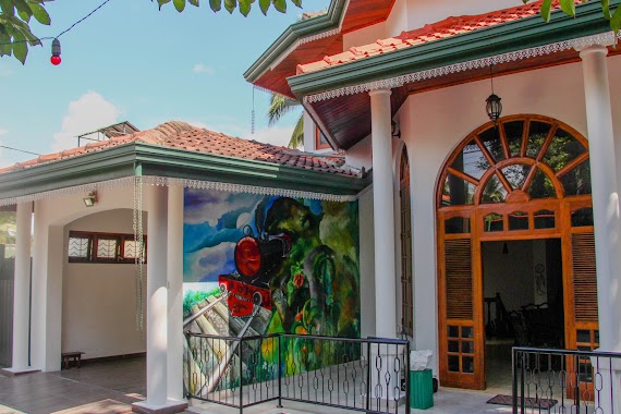
Sparrows Nest
Kandy, Sri Lanka
contacts phone
:
+94
Latitude:
7.3014467
, Longitude:
80.6475988
larger map & directions
read more
nearest Lodging
76 m
Enrich Bangalow
147 Dharmashoka Mawatha, Kandy
Lodging
read more
158 m
Beverly inn
Lewalla Road, Kandy
Lodging
read more
200 m
Waldhaus Kandy
7.299835, 80.646790, Kandy
Lodging
read more
213 m
Jayawimana
147/20, Dharmasoka Mawatha Lewella, මහනුවර
Lodging
read more
248 m
Liyya Residence
No. 07, Badhuwatte Lane,, මහනුවර
Lodging
read more
330 m
Peace Heaven
50 Wagolla Road, Kandy
Lodging
read more
598 m
Riverview - Kandy
No. 17, Gangasiriwatta, Gunnepana,, Sirimalwatta
Lodging
read more
634 m
Kandy Holiday Residence
No. 19/ 5 P.L.P. Alwis Mawatha, Kandy, Kandy
Lodging
read more
674 m
Sen Villa
Sirimalwatta
Lodging
read more
738 m
Nook Rest
No 10, Lewella road, Kandy
Lodging
read more
752 m
Dreamscape Kandy Homestay
8/2, Senpathi Parami Kulathunga Mawatha, Kandy
Lodging
read more
760 m
Veraima Kandy
No, 15 Gangagawa watta, sirimalwatta, gunnapana, Kandy
Lodging
read more
839 m
GreenWoods Guest Kandy
34/A Sangamitta Mawatha, Kandy
Lodging
read more
876 m
Forest Glen Hotel
Kandy
Lodging
read more
899 m
Mount Glimpse
Aruppola Lane 2, Kandy
Lodging
read more
899 m
Mount Glimpse Kandy
Aruppola Lane 2, Kandy
Lodging
read more
917 m
Fairlee Guest House
No 26/A Sangamitta Mawatha, Kandy
Lodging
read more
941 m
Nature Walk Resort
No 9 Sangamitha Road, Kandy
Lodging
read more
989 m
Villa Forest View - No: 50/17
No:50/17, Uplands, Kandy, මහනුවර
Lodging
read more
1.084 km
Kandy jungle view
16/16, Uplands Road, Kandy
Lodging
read more
1.095 km
KANDY HILL VIEW Home Stay
10 Uplands Road, Kandy
Lodging
read more
1.146 km
Kandy Mountain Home
29/19 B,, Devala Road, Kandy
Lodging
read more
1.227 km
Aria Hills
25 Dharmashoka Mawatha, Kandy
Lodging
read more
1.305 km
Olde Empire
21 Temple Street, Kandy
Lodging
read more
1.339 km
Auditor Genaral Department Bunglow
Dharmashoka Mawatha, Kandy
Lodging
read more
📑
all categories
Accounting
Administrative area level 1
Administrative area level 2
Airport
Amusement park
Aquarium
Art gallery
Atm
Bakery
Bank
Bar
Beauty salon
Bicycle store
Book store
Bowling alley
Bus station
Cafe
Campground
Car dealer
Car rental
Car repair
Car wash
Casino
Cemetery
Church
City hall
Clothing store
Colloquial area
Convenience store
Country
Courthouse
Dentist
Department store
Doctor
Electrician
Electronics store
Embassy
Finance
Fire station
Florist
Food
Funeral home
Furniture store
Gas station
General contractor
Grocery or supermarket
Gym
Hair care
Hardware store
Health
Hindu Temple
Home goods store
Hospital
Insurance agency
Intersection
Jewelry store
Laundry
Lawyer
Library
Light rail station
Liquor store
Local government office
Locality
Locksmith
Lodging
Meal delivery
Meal takeaway
Mosque
Movie rental
Movie theater
Moving company
Museum
Natural feature
Neighborhood
Night club
Painter
Park
Parking
Pet store
Pharmacy
Physiotherapist
Place of worship
Plumber
Point of interest
Police
Political
Post office
Premise
Real estate agency
Restaurant
Roofing contractor
Route
Rv park, camping
School
Shoe store
Shopping mall
Spa
Stadium
Storage
Store
Subpremise
Supermarket
Synagogue
Taxi stand
Train station
Transit station
Travel agency
University
Veterinary care
Zoo
administrative area level 3
sublocality level 1
sublocality level 2
↑