Meal takeaway nearby Ranka Take Away Food Cabin
Sri Lanka
Meal takeaway nearby Ranka Take Away Food Cabin
Ranka Take Away Food Cabin
Puttalam - Colombo Road, 11450, Katunayake, Gampaha, LK Sri Lanka
contacts phone
:
+94 114 963 232
Latitude:
7.1587588
, Longitude:
79.8707321
larger map & directions
read more
nearest Meal takeaway
3.147 km
Sanithu foods
Kotugoda Road, Katunayake
Meal takeaway
read more
3.383 km
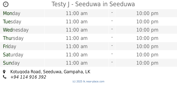
Testy J - Seeduwa
Kotugoda Road, Seeduwa
Meal takeaway
read more
3.397 km
Tasty J
Seeduwa
Meal takeaway
read more
5.579 km
Rimi Foods
Nivasie Pura
Meal takeaway
read more
6.263 km
Calton Sweet House
Negombo
Meal takeaway
read more
8.499 km
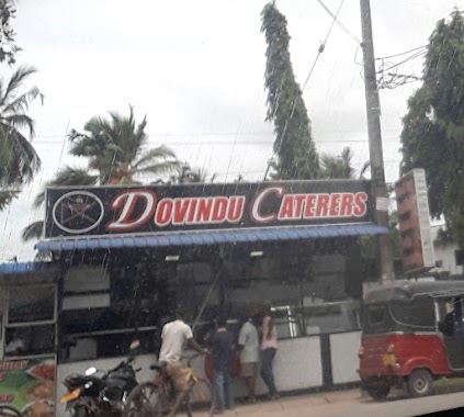
Dovindu Caterers
Kanuwana - Kurunduwaththa, Ja-Ela
Meal takeaway
read more
8.586 km
Red Chilly
Minuwangoda Road, Ja-Ela
Meal takeaway
read more
8.598 km
Hot Chilly
Kanuwana Junction, Ja-Ela
Meal takeaway
read more
9.354 km
Masha Foods
Nedagamuwa
Meal takeaway
read more
14.834 km
Route 240
Welisara
Meal takeaway
read more
15.294 km
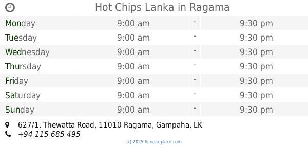
Hot Chips Lanka
627/1 Thewatta Road, Ragama
Meal takeaway
read more
15.422 km
Laksiri Hotel and Grocery
Narangoda Paluwa
Meal takeaway
read more
15.688 km
S.K.D. Hotel
Ragama
Meal takeaway
read more
15.787 km
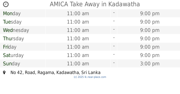
AMICA Take Away
No 42, Road, Ragama, Kadawatha
Meal takeaway
read more
15.81 km
NP Roast Chicken
Ragama
Meal takeaway
read more
15.818 km
Casual Takeaway
Ragama
Meal takeaway
read more
18.213 km
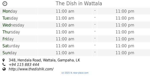
The Dish
348 Hendala Road, Wattala
Meal takeaway
read more
18.24 km
Poori Hut
Wattala
Meal takeaway
read more
18.26 km
Roast Chicken
Hendala Road, Wattala
Meal takeaway
read more
18.66 km
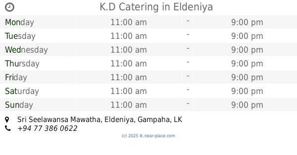
K.D Catering
Sri Seelawansa Mawatha, Eldeniya
Meal takeaway
read more
19.226 km
Maxies Food Hut
Chilaw Road Dummaladeniya
Meal takeaway
read more
21.284 km
Apple White Fresh
Colombo - Kandy Road, Kiribathgoda
Meal takeaway
read more
21.302 km
Rasai Machang
27/D Colombo - Kandy Road, Kelaniya
Meal takeaway
read more
23.095 km
Pubudu Food Center
Peliyagoda
Meal takeaway
read more
28.238 km
Malith Catering Service
Kurunegala
Meal takeaway
read more
📑
all categories
Accounting
Administrative area level 1
Administrative area level 2
Airport
Amusement park
Aquarium
Art gallery
Atm
Bakery
Bank
Bar
Beauty salon
Bicycle store
Book store
Bowling alley
Bus station
Cafe
Campground
Car dealer
Car rental
Car repair
Car wash
Casino
Cemetery
Church
City hall
Clothing store
Colloquial area
Convenience store
Country
Courthouse
Dentist
Department store
Doctor
Electrician
Electronics store
Embassy
Finance
Fire station
Florist
Food
Funeral home
Furniture store
Gas station
General contractor
Grocery or supermarket
Gym
Hair care
Hardware store
Health
Hindu Temple
Home goods store
Hospital
Insurance agency
Intersection
Jewelry store
Laundry
Lawyer
Library
Light rail station
Liquor store
Local government office
Locality
Locksmith
Lodging
Meal delivery
Meal takeaway
Mosque
Movie rental
Movie theater
Moving company
Museum
Natural feature
Neighborhood
Night club
Painter
Park
Parking
Pet store
Pharmacy
Physiotherapist
Place of worship
Plumber
Point of interest
Police
Political
Post office
Premise
Real estate agency
Restaurant
Roofing contractor
Route
Rv park, camping
School
Shoe store
Shopping mall
Spa
Stadium
Storage
Store
Subpremise
Supermarket
Synagogue
Taxi stand
Train station
Transit station
Travel agency
University
Veterinary care
Zoo
administrative area level 3
sublocality level 1
sublocality level 2
↑