Mosque nearby Al Masjidhul Salam
Sri Lanka
Mosque nearby Al Masjidhul Salam
Al Masjidhul Salam
Ovissa Road, Kandy, Central Province, LK Sri Lanka
contacts phone
:
+94 77 742 3618
Latitude:
7.3765146
, Longitude:
80.6096788
larger map & directions
read more
nearest Mosque
311 m
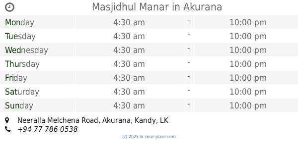
Masjidhul Manar
Neeralla Melchena Road, Akurana
Mosque
read more
588 m
Masjidul Ahsan
Akurana
Mosque
read more
666 m
Masjidul Akaba
Neeralla, Akurana
Mosque
read more
793 m
Riffai Thakkiya Mosque
Rifai Takkiya Road, Akurana
Mosque
read more
817 m
ZamZam Masjid
Sri Lanka
Mosque
read more
944 m
Masjidul Hudha
Akurana
Mosque
read more
960 m
Grand Masjid Akurana
Grand Mosque Road, Akurana
Mosque
read more
979 m
Arafa Masjid
Kasawattha Road, Akurana
Mosque
read more
1.02 km
Malwanahinna Masjid
Malwanahinna
Mosque
read more
1.028 km
Muneer Masjid
Sri Lanka
Mosque
read more
1.058 km
SLTJ AKURANA BRANCH
333/2 A9, Akurana
Mosque
read more
1.058 km
SLTJ AKURANA BRANCH
333/2 Kandy - Jaffna Highway, Akurana
Mosque
read more
1.116 km
Masjidul Huda Jumma Mosque
Sri Lanka
Mosque
read more
1.253 km
Masjidul Aksha
193 Bamunupola Batugoda
Mosque
read more
1.408 km
Arkam Masjid
Kasawathe Road
Mosque
read more
1.543 km
Asna Masjid
Kandy - Jaffna Highway, Akurana
Mosque
read more
1.632 km
Masjidhul mahmoor
Akurana
Mosque
read more
1.652 km
Masjidun Najah
Hingurumuduna Road, Akurana
Mosque
read more
1.655 km
Azhariya Mosque
Dunuwila Road, Akurana
Mosque
read more
1.7 km
Kurugoda Jumma Mosque
Kurugoda
Mosque
read more
1.8 km
Al Masjid Al munawwar
Deegala Road, Akurana
Mosque
read more
1.807 km
Minna mosque
1st Mile Post
Mosque
read more
1.882 km
Al Masjidul Quadiree SAM
Dunuwila Road
Mosque
read more
1.987 km
Al Meezan masjid
Akurana
Mosque
read more
2.177 km
Masjidhul Mukarram
Kandy
Mosque
read more
📑
all categories
Accounting
Administrative area level 1
Administrative area level 2
Airport
Amusement park
Aquarium
Art gallery
Atm
Bakery
Bank
Bar
Beauty salon
Bicycle store
Book store
Bowling alley
Bus station
Cafe
Campground
Car dealer
Car rental
Car repair
Car wash
Casino
Cemetery
Church
City hall
Clothing store
Colloquial area
Convenience store
Country
Courthouse
Dentist
Department store
Doctor
Electrician
Electronics store
Embassy
Finance
Fire station
Florist
Food
Funeral home
Furniture store
Gas station
General contractor
Grocery or supermarket
Gym
Hair care
Hardware store
Health
Hindu Temple
Home goods store
Hospital
Insurance agency
Intersection
Jewelry store
Laundry
Lawyer
Library
Light rail station
Liquor store
Local government office
Locality
Locksmith
Lodging
Meal delivery
Meal takeaway
Mosque
Movie rental
Movie theater
Moving company
Museum
Natural feature
Neighborhood
Night club
Painter
Park
Parking
Pet store
Pharmacy
Physiotherapist
Place of worship
Plumber
Point of interest
Police
Political
Post office
Premise
Real estate agency
Restaurant
Roofing contractor
Route
Rv park, camping
School
Shoe store
Shopping mall
Spa
Stadium
Storage
Store
Subpremise
Supermarket
Synagogue
Taxi stand
Train station
Transit station
Travel agency
University
Veterinary care
Zoo
administrative area level 3
sublocality level 1
sublocality level 2
↑