Mosque nearby Kolonnawa Jumma Mosque
Sri Lanka
Mosque nearby Kolonnawa Jumma Mosque
Kolonnawa Jumma Mosque
151 Kolonnawa Rd, Colombo Sri Lanka
contacts phone
:
+94
Latitude:
6.9331137
, Longitude:
79.8934512
read more
nearest Mosque
27 m
Kollonnawa Jumma Mosque
Kolonnawa Road
Mosque
read more
27 m
Kollonnawa Jumma Mosque
151 Kolonnawa Road, Colombo
Mosque
read more
32 m
Kolonnawa Mosque
Sri Lanka
Mosque
read more
778 m
Централна джамия на Уелампития
Sri Lanka
Mosque
read more
778 m
Wellampitya Jumma Mosque (Zaras Garden)
Sri Lanka
Mosque
read more
778 m
Zaras Garden Jummah Mosque
Sri Lanka
Mosque
read more
799 m
Masjid Al-Nooraniya
Sri Lanka
Mosque
read more
839 m
wellampitiya jummah masjid
Sri Lanka
Mosque
read more
939 m
Masjid Rahma
161/37/3/d/1 Megoda Kolonnawa Road, Kotikawatta
Mosque
read more
970 m
Al Aman Masjid
Kalansooriya Patumaga, Colombo
Mosque
read more
1.001 km
Masjid un Noor
Sri Lanka
Mosque
read more
1.005 km
Masjidun Noor Jummah Mosque
Welewatta
Mosque
read more
1.022 km
Wennawatte Mosque
Wellampitiya
Mosque
read more
1.024 km
Masjid Ammar-Bin-Yassir
79/3, Gothami Mawatha
Mosque
read more
1.385 km
Meerania Jumma Masjidh
Colombo 09
Mosque
read more
1.398 km
Al Masjidul Fuhadiyyah
Welewatta Road, Colombo
Mosque
read more
1.423 km
Masjid Al Taqwa مسجد
Aramaya Place, Colombo
Mosque
read more
1.423 km
Masjid Al Taqwa
Aramaya Place, Colombo
Mosque
read more
1.555 km
Gothotuwa Jumma Masjid
Gotthatuwa Jumma Masjid Road, Kotikawatta
Mosque
read more
1.555 km
Masjid-Ul Jabbar Jumma Masjid
Gotthatuwa Jumma Masjid Road, Kotikawatta
Mosque
read more
1.73 km
Arunodaya mawatha Masjid
Obeysekarapura
Mosque
read more
1.792 km
Bait Ul Hamd
619/4 Baseline Road, Colombo
Mosque
read more
1.924 km
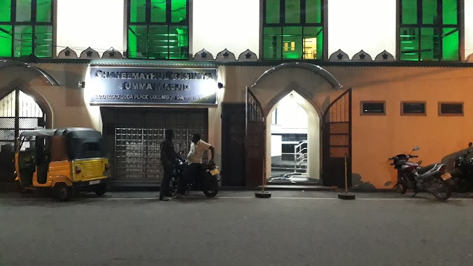
Ghaneemathul Qasmiyya Jumma Masjid
Dematagoda Place, Colombo
Mosque
read more
2.333 km
Musalla Luqman
Colombo
Mosque
read more
2.553 km
Borella Jumma Mosque - Abdeen Mosque
Colombo
Mosque
read more
📑
all categories
Accounting
Administrative area level 1
Administrative area level 2
Airport
Amusement park
Aquarium
Art gallery
Atm
Bakery
Bank
Bar
Beauty salon
Bicycle store
Book store
Bowling alley
Bus station
Cafe
Campground
Car dealer
Car rental
Car repair
Car wash
Casino
Cemetery
Church
City hall
Clothing store
Colloquial area
Convenience store
Country
Courthouse
Dentist
Department store
Doctor
Electrician
Electronics store
Embassy
Finance
Fire station
Florist
Food
Funeral home
Furniture store
Gas station
General contractor
Grocery or supermarket
Gym
Hair care
Hardware store
Health
Hindu Temple
Home goods store
Hospital
Insurance agency
Intersection
Jewelry store
Laundry
Lawyer
Library
Light rail station
Liquor store
Local government office
Locality
Locksmith
Lodging
Meal delivery
Meal takeaway
Mosque
Movie rental
Movie theater
Moving company
Museum
Natural feature
Neighborhood
Night club
Painter
Park
Parking
Pet store
Pharmacy
Physiotherapist
Place of worship
Plumber
Point of interest
Police
Political
Post office
Premise
Real estate agency
Restaurant
Roofing contractor
Route
Rv park, camping
School
Shoe store
Shopping mall
Spa
Stadium
Storage
Store
Subpremise
Supermarket
Synagogue
Taxi stand
Train station
Transit station
Travel agency
University
Veterinary care
Zoo
administrative area level 3
sublocality level 1
sublocality level 2
↑