Mosque nearby Masjidul Umar Jummah Masjid
Sri Lanka
Mosque nearby Masjidul Umar Jummah Masjid
Masjidul Umar Jummah Masjid
Colombo, Sri Lanka
contacts phone
:
+94
Latitude:
6.9467879
, Longitude:
79.8771594
larger map & directions
read more
nearest Mosque
434 m
Masjidul Haneefa
Majeed Road, Colombo
Mosque
read more
533 m
Molawaththa Masjid
Gemunu Patu Mawatha, Colombo
Mosque
read more
564 m
Muhiyaddeen Jumma Mosque
No. 61 St. Joseph's Street Grandpass, කොළඹ
Mosque
read more
588 m
Zavia Masjid
Awwal Zavia Road, Colombo
Mosque
read more
741 m
Al Masjidul Munwwara Jumma Mosque
265/10 10, Sri Saddarma Mawatha, Colombo
Mosque
read more
780 m
Masjidul Falah Jummh Mosque
Colombo
Mosque
read more
861 m
Wadugodawatha Jumma Mosque
Colombo
Mosque
read more
917 m
Bait Ul Hamd
619/4 Baseline Road, Colombo
Mosque
read more
933 m
Srilanka Thowheed Jamaath Mosque
Colombo
Mosque
read more
940 m
Madrasathul Malharis Sulhiyya
Colombo
Mosque
read more
956 m
Masjidus Salam Jumma Masjid
54&56, Maligawatta Lane, Colombo
Mosque
read more
1.033 km
Rahumaniya Masjid
Colombo
Mosque
read more
1.037 km
Tabligh Markaz مسجد
Lukmanjee Square, Colombo
Mosque
read more
1.037 km
Tabligh Markaz
Lukmanjee Square, Colombo
Mosque
read more
1.125 km
Al Rahmath Jumma Mosque Sedawatta
Sedawatta
Mosque
read more
1.125 km
Al Masjidur Rahmath Jumma Mosque
Sedawatta
Mosque
read more
1.214 km
Khairath Jummah Masjidh
Colombo
Mosque
read more
1.353 km
Meerania Jumma Masjidh
Colombo 09
Mosque
read more
1.745 km
Masjid Ammar-Bin-Yassir
79/3, Gothami Mawatha
Mosque
read more
1.783 km
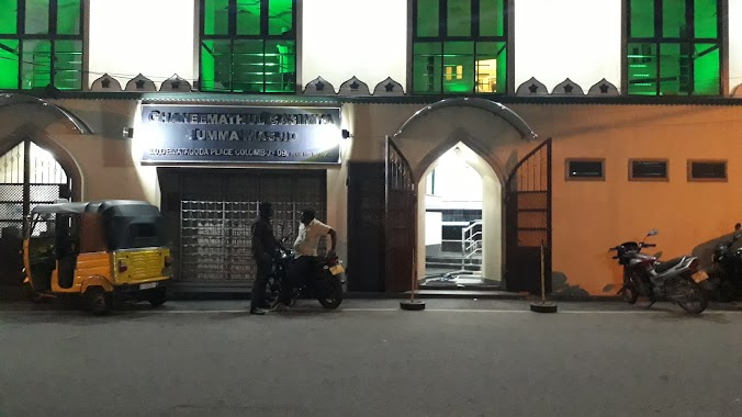
Ghaneemathul Qasmiyya Jumma Masjid
Dematagoda Place, Colombo
Mosque
read more
1.979 km
Al Masjidul Fuhadiyyah
Welewatta Road, Colombo
Mosque
read more
1.985 km
Jamiul Ashroff Mosque
Oilman's Street, Colombo
Mosque
read more
2.056 km
Masjidun Noor Jummah Mosque
Welewatta
Mosque
read more
2.324 km
Kolonnawa Mosque
Sri Lanka
Mosque
read more
2.371 km
Kollonnawa Jumma Mosque
151 Kolonnawa Road, Colombo
Mosque
read more
📑
all categories
Accounting
Administrative area level 1
Administrative area level 2
Airport
Amusement park
Aquarium
Art gallery
Atm
Bakery
Bank
Bar
Beauty salon
Bicycle store
Book store
Bowling alley
Bus station
Cafe
Campground
Car dealer
Car rental
Car repair
Car wash
Casino
Cemetery
Church
City hall
Clothing store
Colloquial area
Convenience store
Country
Courthouse
Dentist
Department store
Doctor
Electrician
Electronics store
Embassy
Finance
Fire station
Florist
Food
Funeral home
Furniture store
Gas station
General contractor
Grocery or supermarket
Gym
Hair care
Hardware store
Health
Hindu Temple
Home goods store
Hospital
Insurance agency
Intersection
Jewelry store
Laundry
Lawyer
Library
Light rail station
Liquor store
Local government office
Locality
Locksmith
Lodging
Meal delivery
Meal takeaway
Mosque
Movie rental
Movie theater
Moving company
Museum
Natural feature
Neighborhood
Night club
Painter
Park
Parking
Pet store
Pharmacy
Physiotherapist
Place of worship
Plumber
Point of interest
Police
Political
Post office
Premise
Real estate agency
Restaurant
Roofing contractor
Route
Rv park, camping
School
Shoe store
Shopping mall
Spa
Stadium
Storage
Store
Subpremise
Supermarket
Synagogue
Taxi stand
Train station
Transit station
Travel agency
University
Veterinary care
Zoo
administrative area level 3
sublocality level 1
sublocality level 2
↑