Park nearby Kid's Park
Sri Lanka
Park nearby Kid's Park
Kid's Park
B632, Peliyagoda, Gampaha, LK Sri Lanka
contacts phone
:
+94
Latitude:
6.9689737
, Longitude:
79.9585489
larger map & directions
read more
nearest Park
1.651 km
hapuarachchi vehicle yard
Sri Lanka
Park
read more
3.481 km
Keselwatta Play Ground
Sri Lanka
Park
read more
4.313 km
Polhena Playground
Peliyagoda
Park
read more
4.434 km
Kadawatha Public Play Ground
Ihala Karagahamuna
Park
read more
4.495 km
Bird Sanctuary
Sri Lanka
Park
read more
4.734 km
University of Kelaniya Playground
University Library, Dalugama
Park
read more
4.745 km
Thel Bemma
Sarasavi Mawatha
Park
read more
4.901 km
Mahara Jogging Track
Gampaha
Park
read more
5.122 km
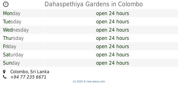
Dahaspethiya Gardens
Kolombo
Park
read more
5.122 km
Dahaspethiya Gardens
Colombo
Park
read more
5.329 km
Haritha Arana Plantation
new town, 313, Himbutana Road, Mulleriyawa, Himbutana Road, Kolonnawa
Park
read more
5.415 km
Walking Track
Wattala
Park
read more
5.738 km
T.B. Ilangaratne Play Ground
Angoda
Park
read more
5.757 km
Oasis Gardens
Kadawatha
Park
read more
5.923 km
Liyenski Garden
Sri Lanka
Park
read more
5.995 km
Bharatha Lakshman Premachandra's statue
Angoda
Park
read more
6.325 km
Raaja Pohottu Garden
Sri Lanka
Park
read more
6.347 km
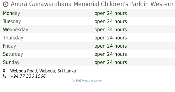
Anura Gunawardhana Memorial Children's Park
Weboda Road, Weboda
Park
read more
6.35 km
MANEL GARDEN SERVICE
203/1, SUHADA MAWATHA PAHALA BOMIRIYA KADUWELA, DAHAMPASAL MAWATHA, COLOMBO KADUWELA
Park
read more
6.529 km
Children's play ground
Station Road, Wattala
Park
read more
9.529 km
Statue of War Indian War Heros
Statue of War Indian War Heros, Parliament Road, Sri Jayawardenepura Kotte
Park
read more
10.357 km
Elie House Park
Colombo
Park
read more
10.42 km
Adventure SEALs
151/1B Dudley Senanayake Mawatha, Colombo
Park
read more
11.789 km
Children's Park
Sri Jayawardenepura Kotte
Park
read more
12.502 km
Nawala walking track
B307, Sri Jayawardenepura Kotte
Park
read more
📑
all categories
Accounting
Administrative area level 1
Administrative area level 2
Airport
Amusement park
Aquarium
Art gallery
Atm
Bakery
Bank
Bar
Beauty salon
Bicycle store
Book store
Bowling alley
Bus station
Cafe
Campground
Car dealer
Car rental
Car repair
Car wash
Casino
Cemetery
Church
City hall
Clothing store
Colloquial area
Convenience store
Country
Courthouse
Dentist
Department store
Doctor
Electrician
Electronics store
Embassy
Finance
Fire station
Florist
Food
Funeral home
Furniture store
Gas station
General contractor
Grocery or supermarket
Gym
Hair care
Hardware store
Health
Hindu Temple
Home goods store
Hospital
Insurance agency
Intersection
Jewelry store
Laundry
Lawyer
Library
Light rail station
Liquor store
Local government office
Locality
Locksmith
Lodging
Meal delivery
Meal takeaway
Mosque
Movie rental
Movie theater
Moving company
Museum
Natural feature
Neighborhood
Night club
Painter
Park
Parking
Pet store
Pharmacy
Physiotherapist
Place of worship
Plumber
Point of interest
Police
Political
Post office
Premise
Real estate agency
Restaurant
Roofing contractor
Route
Rv park, camping
School
Shoe store
Shopping mall
Spa
Stadium
Storage
Store
Subpremise
Supermarket
Synagogue
Taxi stand
Train station
Transit station
Travel agency
University
Veterinary care
Zoo
administrative area level 3
sublocality level 1
sublocality level 2
↑