Park nearby Sri sarananda pirivana car park
Sri Lanka
Park nearby Sri sarananda pirivana car park
Sri sarananda pirivana car park
Anuradhapura, Sri Lanka
contacts phone
:
+94
Latitude:
8.336032
, Longitude:
80.3956559
larger map & directions
read more
nearest Park
634 m
Park
Ranmasu, Uyana Trail, அனுராதபுரம்
Park
read more
1.862 km
Urban Park
New Town
Park
read more
2.015 km
Nature Park
Anuradhapura
Park
read more
2.015 km
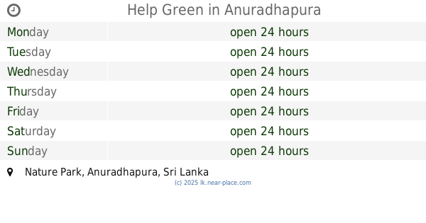
Help Green
Nature Park, Anuradhapura
Park
read more
2.26 km
Stage 1 Children's Park
Anuradhapura
Park
read more
2.345 km
Childrens Park
Anuradhapura
Park
read more
2.514 km
Stage 1 Urban Park
Distrito de Anuradhapura
Park
read more
2.514 km
Stage 1 Urban Park
Anuradhapura
Park
read more
2.846 km
Mahameuna Uyana
Anuradhapura
Park
read more
3.03 km
Himaka Juction
Anuradhapura
Park
read more
3.03 km
Himaka Juction
Distrito de Anuradhapura
Park
read more
3.821 km
Dhammachethiya Meditation Monestry
Watawandana Road, Anuradhapura
Park
read more
11.859 km
Nachchaduwa Nature Park
Nachchaduwa
Park
read more
12.005 km
Lovers Corner පැණිමුල්ල
Trincomalee Road, Mihintale
Park
read more
12.187 km
University Park
Mihintale
Park
read more
13.337 km
Dool Organic Model Farm
Anuradhapura-Rambewa Highway, Rambewa
Park
read more
14.507 km
Eriyagama Wewa talawa
Eriyagama Wewa, Talawa
Park
read more
24.931 km
Medawachchiya City Clock Tower
Kandy - Jaffna Highway, Medawachchiya
Park
read more
25.389 km
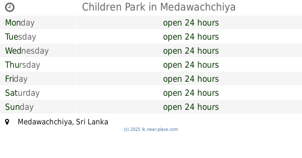
Children Park
Medawachchiya
Park
read more
30.155 km
ROSA'S GARDEN
Meegalewa
Park
read more
37.123 km
Ritigala Strict Natural Reserve
Sri Lanka
Park
read more
37.958 km
Thelbeepuwewa
Sri Lanka
Park
read more
48.137 km
Vavuniya Park New Entramce
Park Road, Vavuniya
Park
read more
48.666 km
Childrens Park
UC Quatas Road, Vavuniya
Park
read more
57.933 km
Elephant Watching With Chathuranga
Minneriya National Park Road, Ambagaswewa, Maradankadawala-Habarana-Thirukkondaiadimadu Highway, Habarana
Park
read more
📑
all categories
Accounting
Administrative area level 1
Administrative area level 2
Airport
Amusement park
Aquarium
Art gallery
Atm
Bakery
Bank
Bar
Beauty salon
Bicycle store
Book store
Bowling alley
Bus station
Cafe
Campground
Car dealer
Car rental
Car repair
Car wash
Casino
Cemetery
Church
City hall
Clothing store
Colloquial area
Convenience store
Country
Courthouse
Dentist
Department store
Doctor
Electrician
Electronics store
Embassy
Finance
Fire station
Florist
Food
Funeral home
Furniture store
Gas station
General contractor
Grocery or supermarket
Gym
Hair care
Hardware store
Health
Hindu Temple
Home goods store
Hospital
Insurance agency
Intersection
Jewelry store
Laundry
Lawyer
Library
Light rail station
Liquor store
Local government office
Locality
Locksmith
Lodging
Meal delivery
Meal takeaway
Mosque
Movie rental
Movie theater
Moving company
Museum
Natural feature
Neighborhood
Night club
Painter
Park
Parking
Pet store
Pharmacy
Physiotherapist
Place of worship
Plumber
Point of interest
Police
Political
Post office
Premise
Real estate agency
Restaurant
Roofing contractor
Route
Rv park, camping
School
Shoe store
Shopping mall
Spa
Stadium
Storage
Store
Subpremise
Supermarket
Synagogue
Taxi stand
Train station
Transit station
Travel agency
University
Veterinary care
Zoo
administrative area level 3
sublocality level 1
sublocality level 2
↑