Point of interest nearby Colours
Sri Lanka
Point of interest nearby Colours
Colours
21 Templers Mawatha, Dehiwala-Mount Lavinia Sri Lanka
contacts phone
:
+94
Latitude:
6.8318984
, Longitude:
79.8770124
read more
nearest Point of interest
181 m
Ebay to Sri Lanka
Templers Road, Dehiwala-Mount Lavinia
Point of interest
read more
394 m
Buvindu Enterprises
6/6 Huludagoda Road, Dehiwala-Mount Lavinia
Point of interest
read more
537 m
Ruwani Wedding Dressing
Dehiwala-Mount Lavinia
Point of interest
read more
641 m
PLASTIMBER IMPEX PVC FOAM SHEET
Kalapura Road, Dehiwala-Mount Lavinia
Point of interest
read more
845 m
ECSI - Educational Consultancy Services International
25 Templers Road, Dehiwala-Mount Lavinia
Point of interest
read more
910 m
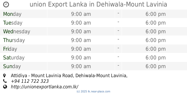
union Export Lanka
134, Attidiya - Mount Lavinia Road, Dehiwala-Mount Lavinia
Point of interest
read more
920 m
S.I. Communication, Book Shop & Grocery
177 Ratmalana Road, Dehiwala-Mount Lavinia
Point of interest
read more
941 m
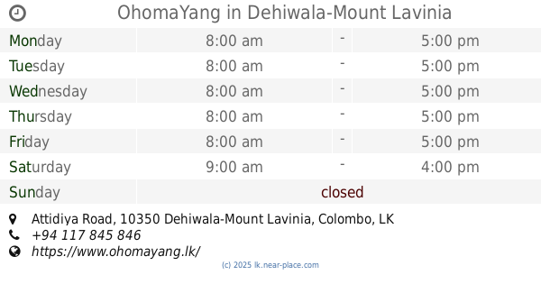
OhomaYang
120A 1/2, Main Street, Bakery Junction, Attidiya Road, Dehiwala-Mount Lavinia
Point of interest
read more
947 m
Dotnutz Solutions (Pvt)Ltd
Dehiwala-Mount Lavinia
Point of interest
read more
948 m
Top Fashion Tailors
2 Hena Rd, Dehiwala-Mount Lavinia
Point of interest
read more
1.008 km
Charm Arts
147/2 Galle Road, Ratmalana, Dehiwala-Mount Lavinia
Point of interest
read more
1.057 km
M & E Turnkey Engineers (Pvt) Ltd.
215 Galle Road, Dehiwala-Mount Lavinia
Point of interest
read more
1.165 km
Studio Lakdam
366 A2, Dehiwala-Mount Lavinia
Point of interest
read more
1.185 km
Lucky Farm Shop
Watarappala Road, Dehiwala-Mount Lavinia
Point of interest
read more
1.273 km
S A Engineers
Dehiwala-Mount Lavinia
Point of interest
read more
📑
all categories
Accounting
Administrative area level 1
Administrative area level 2
Airport
Amusement park
Aquarium
Art gallery
Atm
Bakery
Bank
Bar
Beauty salon
Bicycle store
Book store
Bowling alley
Bus station
Cafe
Campground
Car dealer
Car rental
Car repair
Car wash
Casino
Cemetery
Church
City hall
Clothing store
Colloquial area
Convenience store
Country
Courthouse
Dentist
Department store
Doctor
Electrician
Electronics store
Embassy
Finance
Fire station
Florist
Food
Funeral home
Furniture store
Gas station
General contractor
Grocery or supermarket
Gym
Hair care
Hardware store
Health
Hindu Temple
Home goods store
Hospital
Insurance agency
Intersection
Jewelry store
Laundry
Lawyer
Library
Light rail station
Liquor store
Local government office
Locality
Locksmith
Lodging
Meal delivery
Meal takeaway
Mosque
Movie rental
Movie theater
Moving company
Museum
Natural feature
Neighborhood
Night club
Painter
Park
Parking
Pet store
Pharmacy
Physiotherapist
Place of worship
Plumber
Point of interest
Police
Political
Post office
Premise
Real estate agency
Restaurant
Roofing contractor
Route
Rv park, camping
School
Shoe store
Shopping mall
Spa
Stadium
Storage
Store
Subpremise
Supermarket
Synagogue
Taxi stand
Train station
Transit station
Travel agency
University
Veterinary care
Zoo
administrative area level 3
sublocality level 1
sublocality level 2
↑