Restaurant nearby 141(වන්4ONE Family Restaurant
Sri Lanka
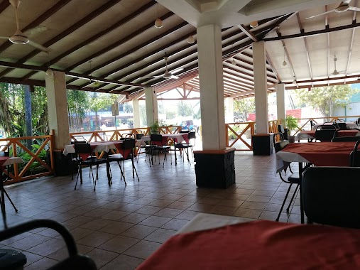
Restaurant nearby 141(වන්4ONE Family Restaurant
141(වන්4ONE Family Restaurant
651, Nittambuwa - Ruwanwella Road, 11880, Nittambuwa, Gampaha, LK Sri Lanka
contacts phone
:
+94 77 323 4342
Latitude:
7.1419269
, Longitude:
80.097739
larger map & directions
read more
nearest Restaurant
167 m
Queen's Take Away
Nittambuwa
Restaurant
read more
284 m
Everest Hotel
23 Aththanagalla Road, Nittambuwa
Restaurant
read more
287 m
Hotel Palace
A1, Nittambuwa
Restaurant
read more
507 m
NOM pastry Shop & Dine In
Colombo - Kandy Road, Nittambuwa
Restaurant
read more
545 m
Imara Chinese food
Nittambuwa
Restaurant
read more
556 m
Ranathisara Reception Hall
A1, Nittambuwa
Restaurant
read more
661 m
Mountain Ray Restaurent
Nittambuwa
Restaurant
read more
666 m
Rasai Machan
Nittambuwa
Restaurant
read more
667 m
New Mega Chille Restaurant
No 583/4, A1, Nittambuwa
Restaurant
read more
735 m
Max Three Resturant
Sri Lanka
Restaurant
read more
745 m
Hemasri Cafe
B445, Nittambuwa
Restaurant
read more
930 m
Pizza Inn
Nittambuwa
Restaurant
read more
1.155 km
Nethmira Food Center
Wathupitiwala Road
Restaurant
read more
1.19 km
Rasai Machan
Gampaha
Restaurant
read more
1.419 km
FoodPack Cafe
Road, Nittambuwa
Restaurant
read more
1.486 km
Twins Hotel
Nittambuwa
Restaurant
read more
1.577 km
Wela Mada Kade
Kandy Road, Nittambuwa
Restaurant
read more
1.577 km
Wela Meda Kade
Kandy Road, Nittambuwa
Restaurant
read more
1.59 km
Golden Apple Family Restaurants
Nittambuwa
Restaurant
read more
1.714 km
Hot Edge Restaurant
Gampaha
Restaurant
read more
1.762 km
Pol Athu Bath Kade
A1
Restaurant
read more
2.322 km
Senani hotel
Wathupitiwala
Restaurant
read more
2.607 km
Sena's Family Restaurant
Malwatta Junction, Nittambuwa
Restaurant
read more
2.624 km
Sena's Family Restaurant
Sri Lanka
Restaurant
read more
3.969 km
Nihal Family Restuarant
173/B Colombo-Kandy Hwy, Pasyala
Restaurant
read more
📑
all categories
Accounting
Administrative area level 1
Administrative area level 2
Airport
Amusement park
Aquarium
Art gallery
Atm
Bakery
Bank
Bar
Beauty salon
Bicycle store
Book store
Bowling alley
Bus station
Cafe
Campground
Car dealer
Car rental
Car repair
Car wash
Casino
Cemetery
Church
City hall
Clothing store
Colloquial area
Convenience store
Country
Courthouse
Dentist
Department store
Doctor
Electrician
Electronics store
Embassy
Finance
Fire station
Florist
Food
Funeral home
Furniture store
Gas station
General contractor
Grocery or supermarket
Gym
Hair care
Hardware store
Health
Hindu Temple
Home goods store
Hospital
Insurance agency
Intersection
Jewelry store
Laundry
Lawyer
Library
Light rail station
Liquor store
Local government office
Locality
Locksmith
Lodging
Meal delivery
Meal takeaway
Mosque
Movie rental
Movie theater
Moving company
Museum
Natural feature
Neighborhood
Night club
Painter
Park
Parking
Pet store
Pharmacy
Physiotherapist
Place of worship
Plumber
Point of interest
Police
Political
Post office
Premise
Real estate agency
Restaurant
Roofing contractor
Route
Rv park, camping
School
Shoe store
Shopping mall
Spa
Stadium
Storage
Store
Subpremise
Supermarket
Synagogue
Taxi stand
Train station
Transit station
Travel agency
University
Veterinary care
Zoo
administrative area level 3
sublocality level 1
sublocality level 2
↑