Restaurant nearby Rasawila Hotel
Sri Lanka
Restaurant nearby Rasawila Hotel
Rasawila Hotel
Ihala Bomiriya, Sri Lanka
contacts phone
:
+94 77 417 6621
Latitude:
6.9352627
, Longitude:
80.0010195
larger map & directions
read more
nearest Restaurant
771 m
The Chef's Choice
No: 112/3, Ihala Bombiriya, Kaduwela
Restaurant
read more
962 m
C.King's Caters
B174, Athurugiriya
Restaurant
read more
1.509 km
Pabavee Hotel
Sri Lanka
Restaurant
read more
1.527 km
Euro Hotel
Colombo - Hanwella Low Level Road
Restaurant
read more
1.539 km
Night Star Restaurant
155/1/G, Bandarawatta, East
Restaurant
read more
1.543 km
La Rosa Food Court
Sri Lanka
Restaurant
read more
1.549 km
Grand Lavinia Restaurant
Kaduwela
Restaurant
read more
1.551 km
Anoma Hotel
Avissawella Road
Restaurant
read more
1.572 km
Hotel 4 You
Sri Lanka
Restaurant
read more
1.576 km
Hotel Monalie
160/4 New Kandy Road
Restaurant
read more
1.596 km
Master Boat Reception Hall
AB10, Kolonnawa
Restaurant
read more
1.597 km
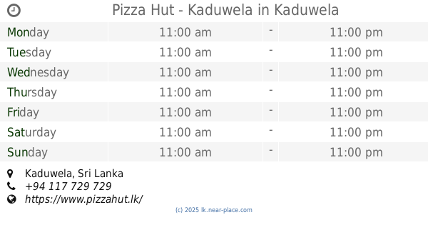
Pizza Hut - Kaduwela
Kaduwela
Restaurant
read more
1.64 km
Sanjaya Vegiterian Hotel
Bandarawatta Junction
Restaurant
read more
1.66 km
Inky Chinese Restaurant
Biyagama East
Restaurant
read more
1.892 km
Imaduwa Bath Kade, ඉමදුව බත් කඩේ
B263, Kaduwela
Restaurant
read more
1.907 km
Shan Food
AB10, Kaduwela
Restaurant
read more
1.972 km
Gemi Gedara
Colombo - Hanwella Low Level Road
Restaurant
read more
1.982 km
Perera & Sons
AB10, Kaduwela
Restaurant
read more
1.982 km
Perera & Sons
Colombo - Hanwella Low Level Road, Kaduwela
Restaurant
read more
2.037 km
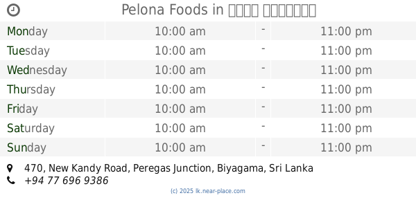
Pelona Foods
470, New Kandy Road, Peregas Junction, Biyagama
Restaurant
read more
2.039 km
Jadiya Restaurant
Biyagama East
Restaurant
read more
2.04 km
Dirluk Restaurant
B214
Restaurant
read more
2.049 km
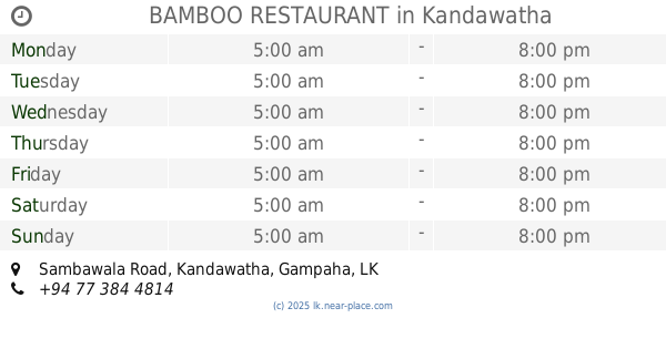
BAMBOO RESTAURANT
52/A/2, Sambawala Road, Kandawatha
Restaurant
read more
2.342 km
Pushpa chandra hotel & grosary
Sri sumanathissa mw, Nawagamuwa
Restaurant
read more
2.452 km
P&S
Nawagamuwa
Restaurant
read more
📑
all categories
Accounting
Administrative area level 1
Administrative area level 2
Airport
Amusement park
Aquarium
Art gallery
Atm
Bakery
Bank
Bar
Beauty salon
Bicycle store
Book store
Bowling alley
Bus station
Cafe
Campground
Car dealer
Car rental
Car repair
Car wash
Casino
Cemetery
Church
City hall
Clothing store
Colloquial area
Convenience store
Country
Courthouse
Dentist
Department store
Doctor
Electrician
Electronics store
Embassy
Finance
Fire station
Florist
Food
Funeral home
Furniture store
Gas station
General contractor
Grocery or supermarket
Gym
Hair care
Hardware store
Health
Hindu Temple
Home goods store
Hospital
Insurance agency
Intersection
Jewelry store
Laundry
Lawyer
Library
Light rail station
Liquor store
Local government office
Locality
Locksmith
Lodging
Meal delivery
Meal takeaway
Mosque
Movie rental
Movie theater
Moving company
Museum
Natural feature
Neighborhood
Night club
Painter
Park
Parking
Pet store
Pharmacy
Physiotherapist
Place of worship
Plumber
Point of interest
Police
Political
Post office
Premise
Real estate agency
Restaurant
Roofing contractor
Route
Rv park, camping
School
Shoe store
Shopping mall
Spa
Stadium
Storage
Store
Subpremise
Supermarket
Synagogue
Taxi stand
Train station
Transit station
Travel agency
University
Veterinary care
Zoo
administrative area level 3
sublocality level 1
sublocality level 2
↑