Restaurant nearby visal Bakers
Sri Lanka
Restaurant nearby visal Bakers
visal Bakers
Sharamadana Avenue, Akmeemana, Galle, LK Sri Lanka
contacts phone
:
+94
Latitude:
6.0852551
, Longitude:
80.2987435
larger map & directions
read more
nearest Restaurant
2.489 km
Madanayake Hotel
18 Isivara
Restaurant
read more
2.665 km
Teachers Home Stay
Sri Lanka
Restaurant
read more
2.666 km
sanuja Pharmacy
Isivara
Restaurant
read more
2.717 km
Mahara Bake House & Restaurant
Kurunduwatta Junction, Walahanduwa
Restaurant
read more
3.185 km
Tharanga Hotel
Galle
Restaurant
read more
3.881 km
hotel Hasara
Galle
Restaurant
read more
4.829 km
Chenu Family Restaurant
Restaurant
read more
5.695 km
Samanthas Bake House සමන්තාස්
B129, Walahanduwa
Restaurant
read more
5.858 km
J S M Restaurant
Galle
Restaurant
read more
6.314 km
Hotel Sesatha
Wanduramba
Restaurant
read more
7.911 km
Way Home hut
Welipatha, Galle
Restaurant
read more
8.105 km
New Siyara Bakers and Restaurant
H.K. Edmond Mawatha, Galle
Restaurant
read more
8.263 km
Kadolana Foods
Galle
Restaurant
read more
8.857 km
Black Tie Restaurant
Unnamed Road, Galle
Restaurant
read more
10.022 km
Coco Beach
A2, Unawatuna
Restaurant
read more
10.032 km
Summer Garden Seafood Restaurant
Unawatuna
Restaurant
read more
10.625 km
Dahana Food Section
Galle
Restaurant
read more
10.904 km
Perera and Sons
No. 36, Gamini Mawatha, Galle
Restaurant
read more
11.088 km
Galle Things Roti
38 Church Street, Galle
Restaurant
read more
11.139 km
Fort Rotti Restaurant
No 36 Y.M.B.A.Building Lighthouse street fort, Galle
Restaurant
read more
11.164 km
Little Fort Juice Corner
3/4 new lane 2 fort, Galle
Restaurant
read more
11.399 km
Galle Kitchen Resturant
No. 126, Colombo Rd, Galle
Restaurant
read more
13.895 km
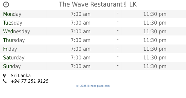
The Wave Restaurant✌
Sri Lanka
Restaurant
read more
17.734 km
WISDOM FAMILY RESORT
Hikkaduwa Road
Restaurant
read more
18.486 km
MANGOES
No:8, 1st lane, walliwala, Weligama
Restaurant
read more
📑
all categories
Accounting
Administrative area level 1
Administrative area level 2
Airport
Amusement park
Aquarium
Art gallery
Atm
Bakery
Bank
Bar
Beauty salon
Bicycle store
Book store
Bowling alley
Bus station
Cafe
Campground
Car dealer
Car rental
Car repair
Car wash
Casino
Cemetery
Church
City hall
Clothing store
Colloquial area
Convenience store
Country
Courthouse
Dentist
Department store
Doctor
Electrician
Electronics store
Embassy
Finance
Fire station
Florist
Food
Funeral home
Furniture store
Gas station
General contractor
Grocery or supermarket
Gym
Hair care
Hardware store
Health
Hindu Temple
Home goods store
Hospital
Insurance agency
Intersection
Jewelry store
Laundry
Lawyer
Library
Light rail station
Liquor store
Local government office
Locality
Locksmith
Lodging
Meal delivery
Meal takeaway
Mosque
Movie rental
Movie theater
Moving company
Museum
Natural feature
Neighborhood
Night club
Painter
Park
Parking
Pet store
Pharmacy
Physiotherapist
Place of worship
Plumber
Point of interest
Police
Political
Post office
Premise
Real estate agency
Restaurant
Roofing contractor
Route
Rv park, camping
School
Shoe store
Shopping mall
Spa
Stadium
Storage
Store
Subpremise
Supermarket
Synagogue
Taxi stand
Train station
Transit station
Travel agency
University
Veterinary care
Zoo
administrative area level 3
sublocality level 1
sublocality level 2
↑