School nearby G.M.C. Preschool
Sri Lanka
School nearby G.M.C. Preschool
G.M.C. Preschool
Galle, Sri Lanka
contacts phone
:
+94
Latitude:
6.0491604
, Longitude:
80.1948121
larger map & directions
read more
nearest School
562 m
Ureka Learners
Galle
School
read more
643 m
amari Hotel
Colombo - Galle Main Road, Galle
School
read more
648 m
Isobethakahasi Montessori
Wekunagoda Road, Galle
School
read more
785 m
BTS Vidyalaya
Dadalla, Galle
School
read more
890 m
National Youth Corps Training Center
Galle
School
read more
1.025 km
Rippon Girls' College
Richmond Hill Road, Galle
School
read more
1.081 km
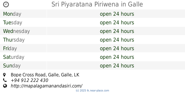
Sri Piyaratana Piriwena
Bope Cross Road, Galle
School
read more
1.098 km
CWW Kannangara Vidyalaya
Mahamodara, Galle
School
read more
1.118 km
Sneath Memorial Playing Field
8/11G Wekunagoda Road, Galle
School
read more
1.123 km
Non-Formal Education Resource Centre
Galle
School
read more
1.123 km
Vocational Training Centre & Artificial Foot Programme
Galle
School
read more
1.145 km
Non Formal Education Resource Center( නොවිධිමත් අධ්යාපන සම්පත් මධ්යස්ථානය)
Sapumal Pedesa, Galle
School
read more
1.169 km
Richmond College
Richmond Hill Road, Galle
School
read more
1.169 km
Richmond College (Started at Methodist Missionary's)
Richmond Hill Road, Galle
School
read more
1.205 km
Piyartissa Maha Vidyalaya
Kalegana, Galle
School
read more
1.221 km
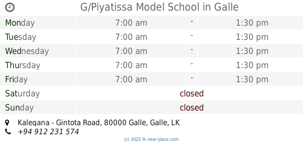
G/Piyatissa Model School
Kalegana - Gintota Road, Galle
School
read more
1.414 km
British College International
Kalegana
School
read more
1.464 km
Mid Way
Wakwella Road, Galle
School
read more
1.583 km
Upeka Hewawasam Dance Academy
363 Wakwella Road, Galle
School
read more
1.617 km
Udara Perapasala
Galle
School
read more
1.674 km
Aya Japanese Language School
621 Colombo - Galle Main Road, Galle
School
read more
1.684 km
Aya Japanese language school
Ginthota, East
School
read more
1.934 km
Masjidul Jamiah
javs lane, Colombo
School
read more
2.438 km
G/Ginthota Maha Vidyalaya
Galle
School
read more
2.447 km
Mount Calvary High School
Galle
School
read more
📑
all categories
Accounting
Administrative area level 1
Administrative area level 2
Airport
Amusement park
Aquarium
Art gallery
Atm
Bakery
Bank
Bar
Beauty salon
Bicycle store
Book store
Bowling alley
Bus station
Cafe
Campground
Car dealer
Car rental
Car repair
Car wash
Casino
Cemetery
Church
City hall
Clothing store
Colloquial area
Convenience store
Country
Courthouse
Dentist
Department store
Doctor
Electrician
Electronics store
Embassy
Finance
Fire station
Florist
Food
Funeral home
Furniture store
Gas station
General contractor
Grocery or supermarket
Gym
Hair care
Hardware store
Health
Hindu Temple
Home goods store
Hospital
Insurance agency
Intersection
Jewelry store
Laundry
Lawyer
Library
Light rail station
Liquor store
Local government office
Locality
Locksmith
Lodging
Meal delivery
Meal takeaway
Mosque
Movie rental
Movie theater
Moving company
Museum
Natural feature
Neighborhood
Night club
Painter
Park
Parking
Pet store
Pharmacy
Physiotherapist
Place of worship
Plumber
Point of interest
Police
Political
Post office
Premise
Real estate agency
Restaurant
Roofing contractor
Route
Rv park, camping
School
Shoe store
Shopping mall
Spa
Stadium
Storage
Store
Subpremise
Supermarket
Synagogue
Taxi stand
Train station
Transit station
Travel agency
University
Veterinary care
Zoo
administrative area level 3
sublocality level 1
sublocality level 2
↑