School nearby J/Anaipanthy M.M. Vidyalayam
Sri Lanka
School nearby J/Anaipanthy M.M. Vidyalayam
J/Anaipanthy M.M. Vidyalayam
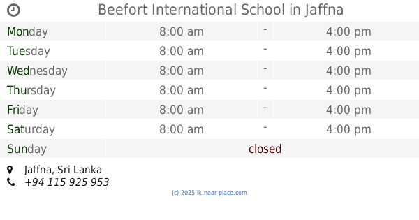
Jaffna, Sri Lanka
contacts phone
:
+94
Latitude:
9.6712001
, Longitude:
80.0212705
larger map & directions
read more
nearest School
7 m
J/ Anaipanthy M M Vidhyalayam
Jaffna
School
read more
518 m
DMI Tution Center
266/1 Stanly Road, Jaffna
School
read more
521 m
Kantharmadam Tamil School
Jaffna
School
read more
522 m
Uki
124, Rasavinthoddam Road, Jaffna
School
read more
529 m
Kantharmadam Saivapirakasa Vidyalayam (கந்தர்மடம் சைவப்பிரகாச வித்தியாலயம்)
Nallur-Oddumadam Road, Jaffna
School
read more
556 m
Sanmarkka Maha Vidyalayam
Jaffna
School
read more
579 m
J/Sanmarkka Maha Vidyalayam
Jaffna
School
read more
757 m
Department of Quantity Surveying - BCAS Jaffna Campus
Jaffna
School
read more
757 m
Department of QS - BCAS Jaffna Campus
Jaffna
School
read more
813 m
Beefort International School
Jaffna
School
read more
859 m
Nallur Hindu Tamil Vidiyalam
Jaffna
School
read more
860 m
St John's Bosco (Nursery)
Rakka Road, Jaffna
School
read more
871 m
J/Nallur Hindu Tamil Girls School(J/Nallur Mankaiyarkarasi Vid)
383 Kovil Road, Jaffna
School
read more
931 m
British Royal Colleg
267, Power House Road, Jaffna
School
read more
935 m
நல்லூர் மங்கயக்கரசி வித்தியாலயம் Nallur Mangayarkarasi Vidyalayam Jaffna
383 Kovil Road, Jaffna
School
read more
1.017 km
Jaffna Hindu Ladies College
Arasadi Road, Jaffna
School
read more
1.022 km
St.John's Bosco
Jaffna
School
read more
1.022 km
St.John's Bosco
Dżafna
School
read more
1.022 km
St John Bosco's Scool
Rakka Road, Jaffna
School
read more
1.022 km
St Mary's R.C.T.M.S
Jaffna
School
read more
1.039 km
ELAS
C Ponnampalam Road, Jaffna
School
read more
1.106 km
Chemistry Court
88/8 Nallur-Oddumadam Road, Jaffna
School
read more
1.108 km
Anboli Institute
88/8 Nallur-Oddumadam Road, Jaffna
School
read more
1.192 km
Cumaraswamy Hall, JHC
College Lane, Jaffna
School
read more
1.224 km
Jaffna Hindu College Sabalingam Hall
Jaffna
School
read more
📑
all categories
Accounting
Administrative area level 1
Administrative area level 2
Airport
Amusement park
Aquarium
Art gallery
Atm
Bakery
Bank
Bar
Beauty salon
Bicycle store
Book store
Bowling alley
Bus station
Cafe
Campground
Car dealer
Car rental
Car repair
Car wash
Casino
Cemetery
Church
City hall
Clothing store
Colloquial area
Convenience store
Country
Courthouse
Dentist
Department store
Doctor
Electrician
Electronics store
Embassy
Finance
Fire station
Florist
Food
Funeral home
Furniture store
Gas station
General contractor
Grocery or supermarket
Gym
Hair care
Hardware store
Health
Hindu Temple
Home goods store
Hospital
Insurance agency
Intersection
Jewelry store
Laundry
Lawyer
Library
Light rail station
Liquor store
Local government office
Locality
Locksmith
Lodging
Meal delivery
Meal takeaway
Mosque
Movie rental
Movie theater
Moving company
Museum
Natural feature
Neighborhood
Night club
Painter
Park
Parking
Pet store
Pharmacy
Physiotherapist
Place of worship
Plumber
Point of interest
Police
Political
Post office
Premise
Real estate agency
Restaurant
Roofing contractor
Route
Rv park, camping
School
Shoe store
Shopping mall
Spa
Stadium
Storage
Store
Subpremise
Supermarket
Synagogue
Taxi stand
Train station
Transit station
Travel agency
University
Veterinary care
Zoo
administrative area level 3
sublocality level 1
sublocality level 2
↑