School nearby Pushpadhana Maha Vidyalaya
Sri Lanka
School nearby Pushpadhana Maha Vidyalaya
Pushpadhana Maha Vidyalaya
Poojapitiya Road, Ambatenna, Kandy, LK Sri Lanka
contacts phone
:
+94
Latitude:
7.3516472
, Longitude:
80.6119788
larger map & directions
read more
nearest School
269 m
Ambatenna Primary School
Ambatenna
School
read more
287 m
Ambatenna Central College
Poojapitiya Road, Ambatenna
School
read more
299 m
Regency Higher Education Center
Ambatenna
School
read more
436 m
Niswan model School
Ambatenna
School
read more
664 m
Little World Montessori
Matale Road, Ambatenna
School
read more
722 m
Greenwood College
Ambatenna
School
read more
1.069 km
Kids Campus
240/2 Dodangolla road Akurana, Kandy
School
read more
1.073 km
Yaqeen Model School
Akurana
School
read more
1.179 km
Hapugoda Kanishta Vidyalaya
Sri Lanka
School
read more
1.196 km
Hapugoda Primary School
Hapugoda Primary School, Hapugoda, Ambatenna
School
read more
1.352 km
Islamiyya High School
Telecom Road, A9, Akurana
School
read more
1.383 km
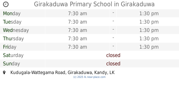
Girakaduwa Primary School
Kudugala-Wattegama Road, Girakaduwa
School
read more
1.383 km
Girakaduwa Primary School
B242, Girakaduwa
School
read more
1.408 km
Darul Uloom school
K M Masjid Road
School
read more
1.746 km
Royal Biblos College
237/1 Matale Road, Katugastota
School
read more
1.762 km
Akurana Muslim Balika Maha Vidyalaya
Akurana
School
read more
1.813 km
Al ILM Open College
Dunuwila Road, Akurana
School
read more
1.872 km
Poojapitiya Primary School
Ahalagashinna, Poojapitiya Road, Pujapitiya
School
read more
1.949 km
Kurundugahaela Muslim Maha Vidiyalaya
Akurana
School
read more
1.963 km
Iqra Pre School
Unnamed Road, Akurana
School
read more
2.007 km
Mahasen Maha Vidyalaya Primary school
Jambugahapitiya
School
read more
2.017 km
Jamiy'a Rahmaniya
Akurana
School
read more
2.047 km
Greenwood International School
Matale Road, Akurana
School
read more
2.127 km
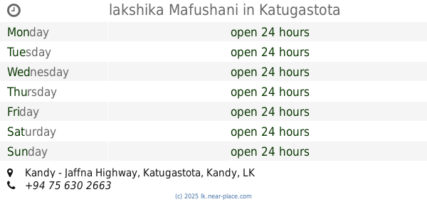
lakshika Mafushani
Kandy - Jaffna Highway, Katugastota
School
read more
2.576 km
Dhammarathana Pirivena
Alawatugoda Road
School
read more
📑
all categories
Accounting
Administrative area level 1
Administrative area level 2
Airport
Amusement park
Aquarium
Art gallery
Atm
Bakery
Bank
Bar
Beauty salon
Bicycle store
Book store
Bowling alley
Bus station
Cafe
Campground
Car dealer
Car rental
Car repair
Car wash
Casino
Cemetery
Church
City hall
Clothing store
Colloquial area
Convenience store
Country
Courthouse
Dentist
Department store
Doctor
Electrician
Electronics store
Embassy
Finance
Fire station
Florist
Food
Funeral home
Furniture store
Gas station
General contractor
Grocery or supermarket
Gym
Hair care
Hardware store
Health
Hindu Temple
Home goods store
Hospital
Insurance agency
Intersection
Jewelry store
Laundry
Lawyer
Library
Light rail station
Liquor store
Local government office
Locality
Locksmith
Lodging
Meal delivery
Meal takeaway
Mosque
Movie rental
Movie theater
Moving company
Museum
Natural feature
Neighborhood
Night club
Painter
Park
Parking
Pet store
Pharmacy
Physiotherapist
Place of worship
Plumber
Point of interest
Police
Political
Post office
Premise
Real estate agency
Restaurant
Roofing contractor
Route
Rv park, camping
School
Shoe store
Shopping mall
Spa
Stadium
Storage
Store
Subpremise
Supermarket
Synagogue
Taxi stand
Train station
Transit station
Travel agency
University
Veterinary care
Zoo
administrative area level 3
sublocality level 1
sublocality level 2
↑